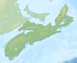
Spanish Bay (Nova Scotia)

Last updated
Spanish Bay
Spanish Bay (Nova Scotia) 1.jpg
Nova Scotia topographic map.png
Red pog.svg
Spanish Bay
Spanish Bay in Nova Scotia
Canada relief map 2.svg
Red pog.svg
Spanish Bay
Spanish Bay (Canada)
Location Cape Breton Island, Nova Scotia
Coordinates 46°16′45″N60°12′42″W / 46.27917°N 60.21167°W / 46.27917; -60.21167
Type Bay
Part of Cabot Strait
River sources Sydney River, Balls Creek, Leitches Creek
Ocean/sea sources Gulf of Saint Lawrence, Atlantic Ocean
Basin  countries Canada
Max. width7 nautical miles (13 km; 8.1 mi)
Settlements Cape Breton Regional Municipality

From west to east:

References Geographical Names of Canada - Spanish Bay

Spanish Bay [1] is a bay in the Canadian province of Nova Scotia. It is located on the Atlantic coast of Cape Breton Island at the mouth of Sydney Harbour, which forms part of Spanish Bay. [2] The current name for the bay, "Spanish Bay" (sometimes "Spanish Harbour", "Spaniards Bay" or "Port aux Espagnols") appears on maps of the area at least as far back as 1708. [3] [4] [5]

Contents

Sailing in Spanish Bay Sailing in Spanish Bay (Nova Scotia).jpg
Sailing in Spanish Bay

Description

Spanish Bay opens to the north-west directly onto the southern terminus of the Cabot Strait and so to the Gulf of Saint Lawrence. The bay measures approximately 7 nautical miles (13 km; 8.1 mi) wide at its mouth, between Alder Point on Boularderie Island to the north-west, and Low Point on Cape Breton Island to the south-east.

The bay's shores are mostly bold & rocky with numerous prominent headlands including Point Aconi, High Cape, Alder Point, Merritt Point, Bonar Head, Oxford Point, Black Point, Cranberry Point, McGillivray Point and Petries Point, although there is a 0.75 kilometres (0.47 mi) sandy beach at Florence Beach and a popular swimming beach at Polar Bear, just to the north of South Bar.

Communities

Communities along the shoreline of Spanish Bay include (from northwest to south to northeast):

Cape Breton County

See also

Related Research Articles

<span class="mw-page-title-main">Cape Breton Island</span> Island in Nova Scotia, Canada

Cape Breton Island is a rugged and irregularly shaped island on the Atlantic coast of North America and part of the province of Nova Scotia, Canada.

<span class="mw-page-title-main">Sydney, Nova Scotia</span> Place in Nova Scotia, Canada

Sydney is a former city and urban community on the east coast of Cape Breton Island in Nova Scotia, Canada within the Cape Breton Regional Municipality. Sydney was founded in 1785 by the British, was incorporated as a city in 1904, and dissolved on 1 August 1995, when it was amalgamated into the regional municipality.

<span class="mw-page-title-main">Cape Breton Highlands National Park</span> National park in Nova Scotia, Canada

Cape Breton Highlands National Park is a Canadian national park on northern Cape Breton Island in Nova Scotia. The park was the first national park in the Atlantic provinces of Canada and covers an area of 948 square kilometres (366 sq mi). It is one of 42 in Canada's system of national parks.

<span class="mw-page-title-main">Bras d'Or Lake</span> Lake in Nova Scotia, Canada

Bras d'Or Lake is an irregular estuary in the centre of Cape Breton Island in Nova Scotia, Canada. It has a connection to the open sea, and is tidal. It also has inflows of fresh water from rivers, making the brackish water a very productive natural habitat. It was designated the Bras d'Or Lake Biosphere Reserve by UNESCO in 2011.

<span class="mw-page-title-main">Mira River (Nova Scotia)</span> River in Nova Scotia, Canada

The Mira River is a Canadian river located in eastern Cape Breton Island, Nova Scotia.

Industrial Cape Breton is a geographic region in the Canadian province of Nova Scotia. It refers to the eastern portion of Cape Breton County fronting the Atlantic Ocean on the southeastern part of Cape Breton Island.

<span class="mw-page-title-main">Geography of Nova Scotia</span>

Nova Scotia is a province located in Eastern Canada fronting the Atlantic Ocean. One of the Maritime Provinces, Nova Scotia's geography is complex, despite its relatively small size in comparison to other Canadian provinces.

<span class="mw-page-title-main">Point Aconi, Nova Scotia</span>

Point Aconi is a rural community in Nova Scotia at the northeastern tip of Boularderie Island. It derives its name from the headland of the same name, Point Aconi.

Big Beach is a community located on the north side of the Boisdale Hills on the east side of the Great Bras D'Or Lake on Provincial Route 223, which runs from Leitches Creek to Little Narrows, through Central Cape Breton Island in the Canadian province of Nova Scotia. Located on the "Bras D'Or Lakes Scenic Drive" it is part of the Cape Breton Regional Municipality in Central Cape Breton Island.

Upper Leitches Creek is a community in the Canadian province of Nova Scotia, located in the Cape Breton Regional Municipality on Cape Breton Island.

<span class="mw-page-title-main">Point Aconi Generating Station</span> Thermal Generating System in eastern Nova Scotia, Canada

The Point Aconi Generating Station is a 165 MW Canadian electrical generating station located in the community of Point Aconi, Nova Scotia, a rural community in the Cape Breton Regional Municipality. A thermal generating station, the Point Aconi Generating Station is owned and operated by Nova Scotia Power Corporation. It opened on August 13, 1994 following four years of construction.

St. Georges Bay is a bay with shore on the Nova Scotia peninsula and Cape Breton Island, Canada, thus comprising a sub-basin of the Gulf of St. Lawrence.

<span class="mw-page-title-main">East Bay (Nova Scotia)</span> Bay in Cape Breton Island, Nova Scotia

East Bay is a bay of the Bras d'Or Lake on Cape Breton Island in the Canadian province of Nova Scotia. It lies entirely within Cape Breton County.

<span class="mw-page-title-main">Wilkie Sugar Loaf</span> Mountain in Nova Scotia, Canada

Wilkie Sugar Loaf is a Canadian peak in the Cape Breton Highlands near the community of Sugar Loaf in the province of Nova Scotia.

St. Patricks Channel is an arm of the Bras d'Or Lake located on Cape Breton Island, in the Canadian province of Nova Scotia. St. Patricks Channel lies entirely within Victoria County.

<span class="mw-page-title-main">Northside-Westmount</span> Provincial electoral district in Nova Scotia, Canada

Northside-Westmount is a provincial electoral district in Nova Scotia, Canada, that elects one member of the Nova Scotia House of Assembly.

<span class="mw-page-title-main">Sydney Harbour (Nova Scotia)</span> Inlet near Sydney, Nova Scotia Canada

Sydney Harbour is the 10-mile long Y-shaped inlet of the Atlantic, oriented southwest-northeast on the northeast shore of Cape Breton Island, Nova Scotia. At its upper reaches, the harbour forks to form two arms: the Northwest Arm and the South Arm. The South Arm is fed upstream by the Sydney River.

References

  1. "Geographical Names of Canada - Spanish Bay" . Retrieved 5 June 2018.
  2. "Nova Scotia Geographical Names Database entry for "Spanish Bay, County of Cape Breton" (includes map)". Government of Nova Scotia. Retrieved 9 May 2020.
  3. "A new map of Nova Scotia and Cape Britain, with the adjacent parts of New England and Canada, composed from a great number of actual surveys, and other materials regulated by many new astronomical observations of the longitude as well as latitude - David Rumsey Historical Map Collection (includes map)". Thomas Jefferys, London, 1755. Retrieved April 8, 2012.
  4. "A new & accurate map of the islands of Newfoundland, Cape Briton, St. John and Anticosta; together with the neighbouring countries of Nova Scotia, Canada &c. Drawn from the most approved modern maps and charts, and regulated by astronl. observatns. - David Rumsey Historical Map Collection (includes map)". William Innys [et al.], London, 1747. Retrieved April 8, 2012.
  5. "Carte du Canada ou de la Nouvelle France et des decouvertes que y ont ete faites. Dressee sur plusieurs observations et sur un grand nombre de relations imprimees ou manuscrites. Par Guillaume Del'Isle, Geographe de l'Academie Royale des Sciences. A Paris - David Rumsey Historical Map Collection (includes map)". Guillaume DeLisle, Quai de l'Horloge a l'Aigle d'Or, Paris, 1708. Retrieved April 8, 2012.
Notes