Cape Breton Island is a rugged and irregularly shaped island on the Atlantic coast of North America and part of the province of Nova Scotia, Canada.

Sydney is a former city and urban community on the east coast of Cape Breton Island in Nova Scotia, Canada within the Cape Breton Regional Municipality. Sydney was founded in 1785 by the British, was incorporated as a city in 1904, and dissolved on 1 August 1995, when it was amalgamated into the regional municipality.

Cape Breton Regional Municipality is the Canadian province of Nova Scotia's second largest municipality and the economic heart of Cape Breton Island. As of 2021 the municipality has a population of 93,694. The municipality was created in 1995 through the amalgamation of eight municipalities located in Cape Breton County.
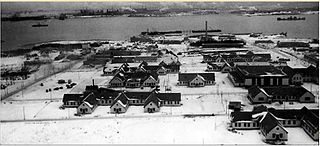
Royal Canadian Navy base HMCS Protector, also known as the Point Edward Naval Base, was located next to Sydney Harbour, on Nova Scotia's Cape Breton Island. It was founded in 1940 and used by the navy during the Second World War. It was mainly used to provision, protect and repair the various merchant marine convoys to Quebec, Halifax, and the United Kingdom. It was a main combat zone during the Battle of the St. Lawrence and the more general Battle of the Atlantic. It continued to be utilized during the Cold War's early stages. It was decommissioned in 1964 and became the initial facility to house the Canadian Coast Guard College that same year. Currently, the Sydport Industrial Park utilizes the base's former piers and land.

The Sydney Tar Ponds were a hazardous waste site on Cape Breton Island in Nova Scotia, Canada.

The Cape Breton and Central Nova Scotia Railway is a short line railway that operates in the Canadian province of Nova Scotia. CBNS operates of main line and associated spurs between Truro in the central part of the province to Point Tupper on Cape Breton Island.
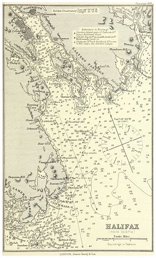
Halifax Harbour is a large natural harbour on the Atlantic coast of Nova Scotia, Canada, located in the Halifax Regional Municipality. Halifax largely owes its existence to the harbour, being one of the largest and deepest ice-free natural harbours in the world. Before Confederation it was one of the most important commercial ports on the Atlantic seaboard. In 1917, it was the site of the world's largest man-made accidental explosion, when the SS Mont-Blanc blew up in the Halifax Explosion on December 6.

Sydney Mines is a community and former town in Cape Breton Regional Municipality, Nova Scotia, Canada.
Point Edward is a community in Nova Scotia's Cape Breton Regional Municipality located on the southwest shore of the North West Arm of Sydney Harbour, immediately north of the community of North West Arm, south of Edwardsville, and west of Westmount.

Sheet Harbour is a rural community in Nova Scotia, Canada. It is located in the eastern reaches of the Halifax Regional Municipality, approximately 117 km (73 mi) northeast of the central urban area of the municipality, concentrated on Downtown Halifax and Dartmouth. The community is located along the Marine Drive scenic route on Trunk 7 at its junctions with Route 224 and Route 374. Surrounding the branched harbour which its name is derived from, the community has a population of about 800 and its respective census tract, containing sizable amounts of land around the community, has a population of 3,478 as of the 2011 Census. Two rivers, West River and East River, flow through the community and into the Northwest and Northeast Arms of the harbour respectively. The coastline of the community is heavily eroded and the region in which the community is located has an abundance of lakes. The region has a humid continental climate, congruent with the majority of Nova Scotia, and the ocean significantly influences the temperature.
Scouting in Nova Scotia has a long history, from 1908 to the present day. There is early record of Boys' Brigade scouts, Canadian Boy Scouts and Salvation Army's Life-Saving Scouts in Nova Scotia. Scouting in Nova Scotia is currently conducted by local Scout groups and various associations including Scouts Canada, L'Association des Scouts du Canada and Canadian Federation of Independent Scouts affiliates such as BPSA - Nova Scotia.

The Dominion Steel and Coal Corporation was a Canadian coal mining and steel manufacturing company. Incorporated in 1928 and operational by 1930, DOSCO was predated by the British Empire Steel Corporation (BESCO), which was a merger of the Dominion Coal Company, the Dominion Iron and Steel Company and the Nova Scotia Steel Company. DOSCO was one of the largest private employers in Canada during the 1930s–1950s. In 1957, DOSCO was purchased as a subsidiary of A.V. Roe Canada Ltd.
Dingwall is an unincorporated area of approximately 600 residents in the Aspy Bay region of the Municipality of the County of Victoria, Nova Scotia, Canada. It is situated just off the Cabot Trail, 84.68 kilometers northeast of county seat Baddeck. The federal electoral riding is Sydney—Victoria.

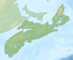
Nova Scotia is a province located in Eastern Canada fronting the Atlantic Ocean. One of the Maritime Provinces, Nova Scotia's geography is complex, despite its relatively small size in comparison to other Canadian provinces.
Melford International Terminal is a proposed Canadian marine-rail container terminal to be built in the community of Middle Melford in Guysborough County, Nova Scotia.
Portage is a community in the Canadian province of Nova Scotia, located in the Cape Breton Regional Municipality on Cape Breton Island.
Leitches Creek is a community in the Canadian province of Nova Scotia, located in the Cape Breton Regional Municipality on Cape Breton Island. It is located along a creek of the same name which flows into the Northwest Arm of Sydney Harbour.
Reputably the stream was named by Adam Moore after a family of Lowland Scots people he helped settle here in the 1780s. Settlement probably began soon after 1783 although the land was not granted until the late 19th and early 20th centuries.
This is a bibliography of major works on Nova Scotia.

The East River Bridge is a multi-span bridge in Sheet Harbour, Nova Scotia that carries Trunk 7 and the Marine Drive scenic route over the Northeast Arm of Sheet Harbour. The bridge is 183 m (600 ft) in length and was constructed from September 2014 to December 2015. It was opened on December 17, 2015 to pedestrians, with a bridge walk commemorating the closing of the old bridge and the opening of the new bridge. The bridge was opened to vehicles the day after. It replaced a green steel arch bridge of the same name that was built in 1956 immediately north of the current bridge. The previous bridge had a span of 213 m (699 ft) and shared engineering ties with the Angus L. MacDonald Bridge in Halifax. Nova Scotia was considering repairs to the old bridge, but they ultimately elected to construct a new bridge instead. The current bridge was designed without overhead arches, unlike its predecessor, as the construction cost would have been doubled.

Nova Scotia has two major national parks, Cape Breton Highlands National Park and Kejimkujik National Park. Nova Scotia is also home to three UNESCO World Heritage Sites.. The two cultural and one natural site are the town of Lunenberg, the Grand-Pré National Historic Site, and the Joggins fossil cliffs. Nova Scotia is also famous for its numerous historical sites, museums, and natural areas.