Canada
New Brunswick
- Gaspereau River (Northumberland Strait), near Port Elgin
- Gaspereau River (Salmon River tributary), near Chipman
Gaspereau River may refer to the following rivers:

The Annapolis Valley is a valley and region in the province of Nova Scotia, Canada. It is located in the western part of the Nova Scotia peninsula, formed by a trough between two parallel mountain ranges along the shore of the Bay of Fundy. Statistics Canada defines the Annapolis Valley as an economic region, composed of Annapolis County, Kings County, and Hants County.

Wolfville is a Canadian town in the Annapolis Valley, Kings County, Nova Scotia, located about 100 kilometres (62 mi) northwest of the provincial capital, Halifax. The town is home to Acadia University and Landmark East School.

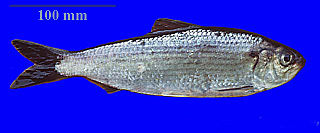
The alewife is an anadromous species of herring found in North America. It is one of the "typical" North American shads, attributed to the subgenus Pomolobus of the genus Alosa. As an adult it is a marine species found in the northern West Atlantic Ocean, moving into estuaries before swimming upstream to breed in freshwater habitats, but some populations live entirely in fresh water. It is best known for its invasion of the Great Lakes by using the Welland Canal to bypass Niagara Falls. Here, its population surged, peaking between the 1950s and 1980s to the detriment of many native species of fish. In an effort to control it biologically, Pacific salmon were introduced, only partially successfully. As a marine fish, the alewife is a US National Marine Fisheries Service "Species of Concern".

The Minas Basin is an inlet of the Bay of Fundy and a sub-basin of the Fundy Basin located in Nova Scotia, Canada. It is known for its extremely high tides.

Gaspereau is a rural community located in Kings County, Nova Scotia, Canada.

Stream capture, river capture, river piracy or stream piracy is a geomorphological phenomenon occurring when a stream or river drainage system or watershed is diverted from its own bed, and flows down to the bed of a neighbouring stream. This can happen for several reasons, including:
Susan (Sue) Goyette is a Canadian poet and novelist.
Port Elgin is a formerly incorporated village in Westmorland County, New Brunswick, Canada. It is located near the Nova Scotia border at the mouth of the Gaspereaux River where it empties into the Northumberland Strait's Baie Verte. It is the government centre of the Strait Shores district, which is a rural community type of local government.

Gaspereau Vineyards is a small winery located in the Gaspereau River Valley of Nova Scotia run by Gina Haverstock. The vineyard encompasses 35 acres (140,000 m2) and is 3 kilometres from downtown Wolfville. It is one of several wineries in Nova Scotia. The winery produces a number of red and white wines, available in dry, off dry, and semi dry. Additionally, icewine and maple wine are made. In 2020 they won a Lieutenant Governor's Award for Excellence in Nova Scotia Wines.

Gaspereau Lake is a lake in Kings County, Nova Scotia, Canada, about 10 km south of the town of Kentville, Nova Scotia on the South Mountain. It is the largest lake in Kings County, and the fifth largest lake in Nova Scotia. The lake is shallow with dozens of forested islands and hundreds of rocky islets (skerries).

The Windsor and Annapolis Railway (W&AR) was a historic Canadian railway that operated in Nova Scotia's Annapolis Valley.

Hortonville is a community in the Canadian province of Nova Scotia, located in Kings County at the mouth of the Gaspereau River and is part of the Landscape of Grand Pré UNESCO World Heritage Site.
Route 116 is a 106 km (66 mi) Canadian secondary highway in southeastern New Brunswick.

Matt Robinson is a Canadian poet born in Halifax, Nova Scotia.
Route 123 is a mostly North/South provincial highway in the Canadian province of New Brunswick. The road runs from Route 10 in Chipman. The road has a length of approximately 52 kilometres, and services small, otherwise isolated rural communities. In these areas, the highway is often unofficially referred to as "Main Street." The Highway is known as Main Street and McLeod Avenue in Chipman. The road is then known as Grand Lake Road from Gaspereau Forks to Doaktown. Lastly upon entering Doaktown, the road is named South Road.

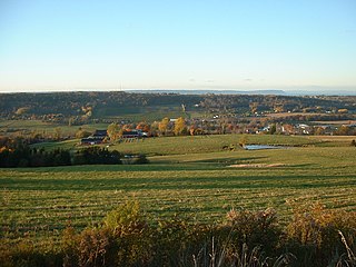
The Gaspereau River is a river in Kings County, Nova Scotia, Canada.
Susan Gillis is a Canadian poet and editor.

The St. Margaret's Bay Hydroelectric System consists of three hydroelectric power plants and the related lake, dam, and river systems driving them. The system is situated within both Lunenburg County and the Halifax Regional Municipality, beginning approximately 2.5 km (1.6 mi) east of the Head of Saint Margarets Bay and approximately 10 km (6.2 mi) southwest of Hammonds Plains. The system is part of the East Indian River watershed and drains 271 square kilometres (105 sq mi), with water storage provided in Lunenburg County by Mill Lake, Coon Pond, Sandy Lake, Wrights Lake, Big Indian Lake, Five Mile Lake and, at times, an overflow from Pockwock Lake in the Halifax Regional Municipality. The system is owned and operated by Nova Scotia Power Inc.
The Gaspereau River is a small river in central New Brunswick, Canada. It flows from Gaspereau Lake into the Salmon River near Gaspereau Forks, which flows into Grand Lake. It is part of the Saint John River watershed.