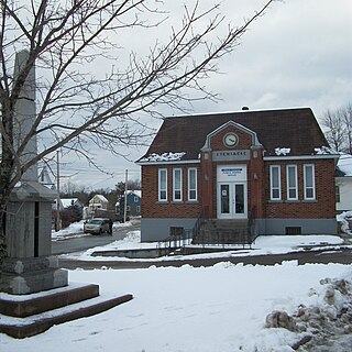
Stewiacke is a town located in southern Colchester County, Nova Scotia, Canada. The town was incorporated on August 30, 1906.

Pictou County is a county in the province of Nova Scotia, Canada. It was established in 1835, and was formerly a part of Halifax County from 1759 to 1835. It had a population of 43,657 people in 2021, a decline of 0.2 percent from 2016. Furthermore, its 2016 population is only 88.11% of the census population in 1991. It is the sixth most populous county in Nova Scotia.

Amherst is a town in northwestern Nova Scotia, Canada, located at the northeast end of the Cumberland Basin, an arm of the Bay of Fundy, and 22 km (14 mi) south of the Northumberland Strait. The town sits on a height of land at the eastern boundary of the Isthmus of Chignecto and Tantramar Marshes, 3 km (1.9 mi) east of the interprovincial border with New Brunswick and 65 km (40 mi) southeast of the city of Moncton. It is 60 km (37 mi) southwest of the New Brunswick abutment of the Confederation Bridge to Prince Edward Island at Cape Jourimain.

Kentville is an incorporated town in Nova Scotia. It is the most populous town in the Annapolis Valley. As of 2021, the town's population was 6,630. Its census agglomeration is 26,929.

Liverpool is a Canadian community and former town located along the Atlantic Ocean of the Province of Nova Scotia's South Shore. It is situated within the Region of Queens Municipality which is the local governmental unit that comprises all of Queens County, Nova Scotia.
Windsor is a community located in Hants County, Nova Scotia, Canada. It is a service centre for the western part of the county and is situated on Highway 101.

Antigonish is a town in Antigonish County, Nova Scotia, Canada. The town is home to St. Francis Xavier University and the oldest continuous Highland games outside Scotland. It is approximately 160 kilometres northeast of Halifax, the provincial capital.
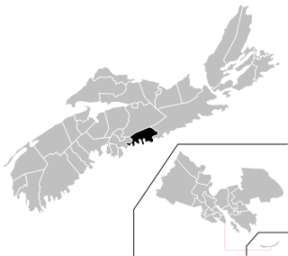
Enfield is an urban community located 5 kilometres (3.1 mi) north of Halifax Stanfield International Airport in the Shubenacadie Valley on the border of Hants and Halifax counties in Nova Scotia, Canada. Specifically, Enfield exists in both the East Hants Municipal District and Halifax and is divided by the Shubenacadie River.

Bedford was a provincial electoral district in Nova Scotia, Canada, that elected one member of the Nova Scotia House of Assembly. Its current Member of the Legislative Assembly is Kelly Regan.

Antigonish is a provincial electoral district in Nova Scotia, Canada, that elects one member of the Nova Scotia House of Assembly. It has existed since 1867 and is one of only four Nova Scotian districts that has existed continuously since Canadian Confederation.
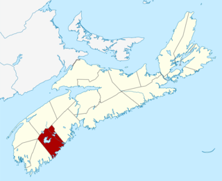
The Region of Queens Municipality is a regional municipality in southwestern Nova Scotia, Canada. It is the northern gateway of the UNESCO Southwest Nova Biosphere Reserve, a centre of outdoor activities. Campgrounds at Kejimukujik National Park and National Historic Site, Thomas H. Raddall Provincial Park, and several other locations offer hiking, biking, canoeing, kayaking, cross-country skiing and snowshoeing. Its seacoast and inland areas are popular photo locations.
Bible Hill is an incorporated village in Colchester County, Nova Scotia. It lies on the north bank of the Salmon River, opposite the town of Truro and the unincorporated community of Salmon River.
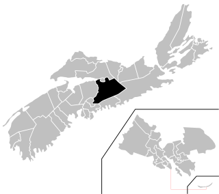
Colchester—Musquodoboit Valley is a provincial electoral district in Nova Scotia, Canada, that elects one member of the Nova Scotia House of Assembly.
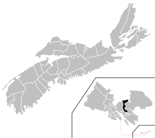
Dartmouth East is a provincial electoral district in Nova Scotia, Canada, that elects one member of the Nova Scotia House of Assembly. The riding is located in the community of Dartmouth, in the urban area of Halifax.
Eastern Shore is a provincial electoral district in Nova Scotia, Canada, that elects one member of the Nova Scotia House of Assembly.

Berwick is a Canadian town in Kings County, Nova Scotia. The town is located in the eastern part of the Annapolis Valley on the Cornwallis River. The town site stretches south from the river and Exit 15 of Highway 101 to Highway 1. Berwick occupies 6.80 km2 and has an elevation of 43 m (141 ft) above sea level.

Christmas tree production in Canada totals from 3 to 6 million trees annually. Trees are produced in many of the provinces of Canada but the nation's leading producers are found in Quebec, Nova Scotia and Ontario, which account for 80 percent of Canadian tree production. Of the 900,000 trees produced annually in British Columbia, most are cut from native pine stands.
Greenfield is a community in the Canadian province of Nova Scotia, located in the Region of Queens Municipality. The sawmill in Greenfield, founded in 1832, is one of the oldest family-run sawmill businesses in North America. Until 1850 the region was occupied mostly by the Mi'kmaq of the Algonquin tribe, who seasonally settled the area below the lakes on either side of what is now called the Medway River and was known by the Mi'kmaq as Wigadoon.

The Stewiacke River is a river in the Canadian province of Nova Scotia that starts at Round Lake in Pictou County and flows into the Shubenacadie River in Colchester County running through the Stewiacke Valley.

Clayton Park West is a provincial electoral district in Nova Scotia, Canada, that elects one member of the Nova Scotia House of Assembly.
