
The Annapolis Valley is a valley and region in the province of Nova Scotia, Canada. It is located in the western part of the Nova Scotia peninsula, formed by a trough between two parallel mountain ranges along the shore of the Bay of Fundy. Statistics Canada defines the Annapolis Valley as an economic region, composed of Annapolis County, Kings County, and Hants County.
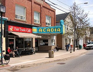
Wolfville is a quiet Canadian town in the Annapolis Valley, Kings County, Nova Scotia, located about 100 kilometres (62 mi) northwest of the provincial capital, Halifax. The town is home to Acadia University and Landmark East School.

The Bay of Fundy is a bay between the Canadian provinces of New Brunswick and Nova Scotia, with a small portion touching the U.S. state of Maine. It is an arm of the Gulf of Maine. Its tidal range is the highest in the world. The name is probably a corruption of the French word fendu, meaning 'split'.

The Minas Basin is an inlet of the Bay of Fundy and a sub-basin of the Fundy Basin located in Nova Scotia, Canada. It is known for its extremely high tides.

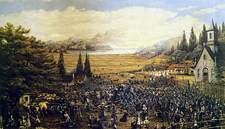
Grand-Pré is a Canadian rural community in Kings County, Nova Scotia. Its French name translates to "Great/Large Meadow" and the community lies at the eastern edge of the Annapolis Valley several kilometres east of the town of Wolfville on a peninsula jutting into the Minas Basin surrounded by extensive dyked farm fields, framed by the Gaspereau and Cornwallis Rivers. The community was made famous by Henry Wadsworth Longfellow's poem Evangeline and is today home to the Grand-Pré National Historic Site. On June 30, 2012, the Landscape of Grand-Pré was named a World Heritage Site by UNESCO.
Grand-Pré National Historic Site is a park set aside to commemorate the Grand-Pré area of Nova Scotia as a centre of Acadian settlement from 1682 to 1755, and the British deportation of the Acadians that happened during the French and Indian War. The original village of Grand Pré extended four kilometres along the ridge between present-day Wolfville and Hortonville. Grand-Pré is listed as a World Heritage Site and is the main component of two National Historic Sites of Canada.

The Acadians are the descendants of 17th and 18th century French settlers in parts of Acadia in the northeastern region of North America comprising what is now the Canadian Maritime Provinces of New Brunswick, Nova Scotia and Prince Edward Island, the Gaspé peninsula in eastern Québec, and the Kennebec River in southern Maine.
Route 358 is a collector road in the Canadian province of Nova Scotia.

The Cornwallis River is in Kings County, Nova Scotia, Canada. It has a meander length of approximately 48 kilometres (30 mi) through eastern Kings County, from its source on the North Mountain at Grafton to its mouth near Wolfville on the Minas Basin. The lower portion of the river beginning at Kentville is tidal and there are extensive tidal marshes in the lower reaches. In its upper watershed at Berwick, the river draws on the Caribou Bog while a longer branch continues to the official source, a stream on the North Mountain at Grafton.

The Battle of Petitcodiac was an engagement which occurred during the Bay of Fundy campaign of the French and Indian War. The battle was fought between the British colonial forces from Massachusetts and Acadian militiamen led by French officer Charles Deschamps de Boishébert et de Raffetot on September 4, 1755. It took place at the Acadian village of Village-des-Blanchard on the Petitcodiac River.
Canard is a rural community occupying a ridge to the north of the Canard River between the Canard and Habitant Rivers in Kings County in the Canadian province of Nova Scotia. The name comes from the French word for duck which was in turn derived from the Mi'kmaw name for the river which described the large numbers of black ducks once found there.
Scotch Village is an unincorporated community on the Kennetcook River in the Canadian province of Nova Scotia, located in the Municipality of West Hants. This area was part of Newport Township at the time of settlement primarily by Rhode Island Planters in the early 1760s. It was referred to as “Scotchman’s Dyke” or “Scotch Village”, due to settlement of early families of Scottish descent. Prior to the arrival of the Planters, Scotch Village had been the home of Mi'kmaq and Acadians.
Starrs Point is a community in the Canadian province of Nova Scotia, located in Kings County two miles (3 km) northeast of Port Williams. Starrs Point faces the Minas Basin to the east and separates the mouths of the Cornwallis River and the Canard River. It is an agricultural area noted for apple orchards, farming and more recently vineyards.

Pisiguit is the pre-expulsion-period Acadian region located along the banks of the Avon River from its confluence with the Minas Basin of Acadia, which is now Nova Scotia, including the St. Croix River drainage area. Settlement in the region commenced simultaneous to the establishment of Grand-Pré. Many villages spread rapidly eastward along the river banks. These settlements became known as Pisiguit or. The name is from the Mi'kmaq Pesaquid, meaning "Junction of Waters". In 1714, there were 351 people there.
Les Mines was the name generally applied the Acadian settlements in the western Minas Basin in Nova Scotia. They included the villages of Grand-Pré, New Minas, Rivière-aux-Canards but usually excluded the villages at Pisiguit, Cobequid, and Beaubassin. The name originated with early French explorers who identified copper mines at Cape d'Or as "Les Mines" and the name was gradually transferred to identify the Basin beyond Cape d'Or and its settlements. Founded in the 1680s, the communities which comprised Les Mines grew and prospered based on skilled development of dyked marsh lands for agriculture. However the settlements were destroyed in the 1755 Bay of Fundy Campaign of the Deportation of the Acadians.
The Bay of Fundy campaign occurred during the French and Indian War when the British ordered the Expulsion of the Acadians from Acadia after the Battle of Fort Beauséjour (1755). The campaign started at Chignecto and then quickly moved to Grand-Pré, Rivière-aux-Canards, Pisiguit, Cobequid, and finally Annapolis Royal. Approximately 7,000 Acadians were deported to the New England colonies.
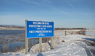
The Wellington Dyke is an agricultural dyke in Kings County, Nova Scotia protecting over 3,000 acres (12 km2) of farmland along the Canard River between the communities of Starr's Point and Canard in Nova Scotia, Canada. Built by local farmers, it was begun in 1817 and completed in 1825. Today the dyke is owned by the Department of Agriculture of Nova Scotia in partnership with the farmers of the Wellington Marsh Body.
Rivière-aux-Canards was an Acadian community located at the west side of the Minas Basin from 1670 until 1755. The community occupied the present-day site of Canard, Port Williams and Starr's Point, Nova Scotia. The village was established in 1670 by the name of Saint-Joseph-de-la-Rivière-aux-Canards, later, it became Rivière-aux-Canards in short form.
Steam Mill Village is a rural community north of Kentville, Nova Scotia, Canada beside Camp Aldershot. It is named after an early steam-powered saw mill.

The Cape Sable campaign occurred in the fall of 1758 during the French and Indian War. The British sought to neutralize Acadian support for the French by deporting them. Colonel Roger Morris led a force of 325 British soldiers, aided by Captain Joseph Gorham with 60 rangers and Rogers' Rangers, to destroy the Acadian settlements in present-day Shelburne County and Yarmouth County, Nova Scotia, Canada.

