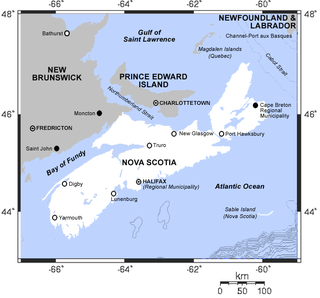
The Framboise River (CAMVI) is an estuary that extends to the northwest from Seal Rocks and Framboise Cove on the coast to where Bagnells River (Bagnells Lake), Middle River Framboise and Northeast Framboise River converge.[1] Strachans Brook and Mary Anns Brook enter the estuary from the south. The mouth of the river is at 45°42′08″N60°19′56″W / 45.702351°N 60.332088°W / 45.702351; -60.332088.[1] The community of Framboise, Nova Scotia, lies to the southwest of the river.[1] "Framboise" means raspberry in French, and probably was given as a descriptive name by the early settlers.[2]
Watershed
Lakes in the watershed include MacArthurs Lake and MacMullin Lake, which are connected by a channel.[3] MacArthurs Lake has been described as "a beautiful pond".[3] It is at 45°47′16″N60°18′10″W / 45.787801°N 60.302678°W / 45.787801; -60.302678.[4] It is at an elevation of 31 metres (102ft).[5] The 5,640 hectares (13,900 acres) Middle-River Framboise Wilderness Area is a relatively inaccessible protected area of wetlands, streams, lakes and well-defined and forested drumlins.[6]
A deposit of ore containing zinc (9.55%), lead (2.28%) and copper (0.94%) was discovered in Strachans Brook in the 1890s. The Stirling base metal deposit, or Mindamar Mine, was purchased by British Metals Corporation, which operated the mine between 1935 and 1938, discharging waste and unrecovered metals directly into the brook. The mine was reopened from 1952 to 1956, with the waste now impounded in a tailings pond.[7] The brook flows slowly eastward through low-gradient swampy reaches for 8 kilometres (5.0mi) to join the Framboise River estuary 4 kilometres (2.5mi) from the coast. There is a small deltaic fan at the mouth of the brook.[8] It is not clear whether the quality of water and sediments in the Frambois River have been degraded by the dispersal of the tailings.[9]
Cape Breton Highlands National Park is a Canadian national park on northern Cape Breton Island in Nova Scotia. The park was the first national park in the Atlantic provinces of Canada and covers an area of 948 square kilometres (366 sq mi). It is one of 42 in Canada's system of national parks.
The name "Miramichi" was first applied to a region in the northeast of New Brunswick, Canada, and has since been applied to other places in Canada and the United States. Although other interpretations have been suggested, it is believed that "Miramichi" was derived from the Montagnais words "Maissimeu Assi", and was perhaps introduced for use in European languages by Jacques Cartier in 1535.
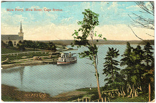
The Mira River is a Canadian river located in eastern Cape Breton Island, Nova Scotia.
The Eastern Shore is a region of the Canadian province of Nova Scotia. It is the Atlantic coast running northeast from Halifax Harbour to the eastern end of the peninsula at the Strait of Canso.
Moser River is a rural community on the Eastern Shore of Nova Scotia, Canada, in the Halifax Regional Municipality. The community lies along the Marine Drive on Trunk 7, 32 km (20 mi) east of Sheet Harbour and 51 km (32 mi) southwest of Sherbrooke. The community is located along the shores of Necum Teuch Harbour, an inlet of the Atlantic Ocean, and is at the mouth of Moser River. The area was called Noogoomkeak in the mi'kmaq language, translating to "soft sand place". The community is named for Henry Moser, who was the son of Jacob Moser, who settled the area in the early 1800s. The first school in the community was built in 1905, and another school, Moser River Consolidated School, was built in 1957. The school closed in 2015, due to its very low student population. Marine Drive Academy in Sheet Harbour serves the community and its surroundings at all grade levels. There is a small seaside park in the community near the former school, as well as a post office and convenience store.
Moose River Gold Mines is a Canadian rural community located in Nova Scotia's Halifax Regional Municipality. It is located at the junction of Moose River Road and Mooseland Road. No numbered highways run through Moose River Gold Mines. Gold was discovered in the area in 1866 and mining started in the 1870s. Interest waned around 1900 but rose in the 1930s. The community gained international attention in 1936 when three men were trapped in the mine.
Lochaber Mines is a rural community on the Eastern Shore of Nova Scotia, Canada, in the Halifax Regional Municipality. It is located along Route 374 about 14 km (8.7 mi) northeast of Sheet Harbour. The community is located along East River and is near the Marshall Flowage, a large lake at the head of East River. The community is named for Lochaber, located in Scotland. In 1812, Alexander Fraser received a grant of land in the area. Several gold leads were opened by J.H. Anderson in 1887 in the area, however, not much work was done outside of exploratory work.
Liscomb Game Sanctuary is a conservation area that straddles the border of Halifax Regional Municipality and Guysborough County in the Canadian province of Nova Scotia. Nova Scotia Route 374 runs north–south through the sanctuary. Within the sanctuary are two nature reserves and parts of two wilderness areas.
Coxheath is a community in the Canadian province of Nova Scotia, located north of the Sydney River in the Cape Breton Regional Municipality on Cape Breton Island. The community is home to Riverview Rural High School, a secondary school with approximately 900 students in Grades 10-12 and Coxheath Elementary.
Frasers Mills is a community in the Canadian province of Nova Scotia, located in Antigonish County on Nova Scotia Route 316.
Framboise is a small community in the Canadian province of Nova Scotia, located in Richmond County. It lies to the southwest of the Framboise River.
MacMullin Lake is a lake of Cape Breton Regional Municipality, Nova Scotia, Canada.
There are various Black Lakes in Nova Scotia, Canada. They vary widely in size, depth and usability. Many counties, such as Cumberland, Halifax, Inverness, and Pictou Counties have more than one Black Lake so named, while other counties mentioned in this article have only one named Black Lake.
The Tusket River is a Canadian river located in Nova Scotia's Yarmouth County.
The East River of Pictou is a Canadian river located in Pictou County, Nova Scotia.
The Middle River of Pictou is a Canadian river located in Pictou County, Nova Scotia.
The Pugwash River is a river in Nova Scotia, Canada. It flows north into the Northumberland Strait in the village of Pugwash
Devils Hill Falls is a waterfall on Devils Hill Brook, flowing off Devils Hill, sited approximately 5.5 kilometres (3.4 mi) south of the Mira River on Cape Breton Island, in the province of Nova Scotia, Canada. The waterfall is in three parts, an upper classical ledge waterfall, about 6 metres (20 ft) of fall, followed by a cascade leading to the lower falls, another classical ledge waterfall, about 4.5 metres (15 ft) in height. The waterfall is a short distance off of New Boston Road, about 3 kilometres (1.9 mi) from the community of Catalone. The falls are located on privately owned property.
This page is based on this Wikipedia article Text is available under the CC BY-SA 4.0 license; additional terms may apply. Images, videos and audio are available under their respective licenses.