Southern Ontario

Last updated
Southern Ontario
Primary region
Southern Ontario
Map of Ontario SOUTHERN.svg

██ Core area ██ Extended area
Coordinates: 44°00′N80°00′W / 44.000°N 80.000°W / 44.000; -80.000
Country Flag of Canada (Pantone).svg  Canada
Province Flag of Ontario.svg  Ontario
Area
  Total114,217 km2 (44,099 sq mi)
  Core area101,264 km2 (39,098 sq mi)
  Extended area12,953 km2 (5,001 sq mi)
Population
 (2021)
  Total13,481,332
  Density118.0/km2 (306/sq mi)
  Core area
13,367,749
  Extended area
113,583
Demonym Southern Ontarian
Time zone UTC−5 (EST)
  Summer (DST) UTC−4 (EDT)
Postal code prefixes
K, L, M, N
Area code(s) 226, 249, 289, 343, 365, 416, 437, 519, 548, 613, 647, 705, 905

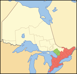
Southern Ontario is a primary region of the Canadian province of Ontario. It is the most densely populated and southernmost region in Canada, with approximately 13.5 million people, approximately 36% of Canada's population of 37 million. [1] The region lies south of the province's other primary region, Northern Ontario, although the exact northern boundary of Southern Ontario is disputed. However, its core region is situated south of Algonquin Park, the latter being in an area of transition between coniferous forest north of the French and Mattawa Rivers and southern deciduous forest. It covers between 14 and 15% of the province, depending on the inclusion of the Parry Sound and Muskoka districts which also lie in the transitional area between northern and southern forest regions. Southern Ontario differs greatly from Northern Ontario, having a much higher population density, a different climate, and a different culture than its northern counterpart. It is broken into smaller subregions, including Central Ontario, Eastern Ontario, the Golden Horseshoe, and Southwestern Ontario.

Contents

The core area of Southern Ontario is part of the Quebec City–Windsor Corridor, which extends northeast into southern Quebec. The transitional northern area of this primary region extends north to the Mattawa River and occupies part of the Grenville Geological Province of the Canadian Shield, which also extends northeast into southern Quebec; most of Northern Ontario lies within the Superior Geological Province.

Identity

Southern Ontario can be distinguished from Northern Ontario because it is far more densely populated and contains most of the province's cities, major roads, and institutions. Northern Ontario, in contrast, contains more natural resources and remote wilderness. Although it has no saltwater coastline, the region has an abundance of freshwater coastlines on three Great Lakes (Huron, Erie and Ontario), as well as smaller lakes such as Lake Simcoe and Lake St. Clair. It is a major vineyard region and producer of Canadian wines. [2]

While Southern Ontario has been a part of the province of Ontario since its establishment at Confederation in 1867, previously forming the colony of Upper Canada, a large portion of Northern Ontario did not become part of Ontario until 1912.

History

Underground Railroad monument, Windsor UndergroundRailroadmonumentWindsor.jpg
Underground Railroad monument, Windsor

The French explored and colonized Territorial Southern Ontario in the 17th century and forged relations with the Wyandot Huron people, based around the Georgian Bay/Lake Simcoe area. Other Iroquoian speaking people to the south were the Petun and Neutral Nation, and further northeast, Algonquins inhabited the upper Ottawa River/Madawaska Valley areas and the Mississaugas moved south from northern Lake Huron, settling lands in both the Kawartha region and just west of Toronto.

Following the Seven Years' War, the British wrested control of Southern Ontario, and more significant colonization efforts were spurred on by the arrival of United Empire Loyalists brought on by the American Revolution.

Southern Ontario was where a large portion of the battles took place during the War of 1812, [3] and was a major destination for escaping slaves using the underground railroad. [4]

Following the enactment of Prohibition in the United States in 1919, Southern Ontario immediately became a hotbed of smuggling alcohol (spirit) across the border.

Demographics

Southern Ontario is home to over 94%, or 12.1 million, of Ontario's total population of 12.9 million (and about 35% of Canada's total population), compared to approximately 750,000 in Northern Ontario. This is due to many factors, including the more arable land in the south, its more moderate climate, well-used transportation (water, land, and air) routes, proximity to populated areas of the Northeastern and Midwestern United States, as well as a long history of early European settlers and colonialism.

For thousands of years, Ontario has been home to indigenous aboriginal communities, with numerous nations with differing languages at the time of European contact. Over 200,000 aboriginal Canadians live in Southern Ontario today.

Southern Ontario was colonized by the French and the British. After the area began to be developed for European settlement, especially after the American Revolutionary War, other European immigrants arrived as well, with increased immigration in the late 19th and early 20th centuries. Since the late 20th century, many immigrants have come from Asia and other parts of the world. The region is one of the top destinations for immigrants worldwide, [5] particularly the Greater Toronto Area.

Toronto skyline tommythompsonpark.jpg
Toronto skyline in 2005

Economy

The area has a large manufacturing sector. Since the mid-2000s, Ontario has produced more vehicles per year than the state of Michigan. [6] In a cross-border definition, a swath of Southern Ontario could be considered a part of the Rust Belt. [7] Factory closings because of industry restructuring and globalization (corresponding movement of jobs overseas and to non-unionized labour markets in the United States) have for the past few decades taken their toll. This is most evident in the region's southern tier cities, which have large automobile or associated industrial bases, such as Windsor, London, St. Thomas and St. Catharines. Still affected by these factors, but to a lesser extent, is Hamilton, the centre of steel production, and Sarnia, the centre of petrochemical production. The province's two largest cities, Toronto and Ottawa, have moved increasingly to a service and knowledge economy. Toronto is home to the country's financial sector, including the major Canadian banks and Toronto Stock Exchange. Ottawa, the national capital, is home to the Government of Canada and most government departments and agencies, in addition to having a strong technology sector. [8] [9]

Some parts of Southern Ontario are heavily entwined with bordering cities in New York and Michigan in terms of industry and people. The focus areas are the Buffalo–Niagara, Sarnia and Detroit–Windsor. Many people work and live on opposite sides of the border. The NEXUS program for frequent travelers across the border [10] is increasing in popularity among bordering communities. Other areas with heavy trade traffic with Southern Ontario include Montreal and the province of Quebec, parts of northern Ohio, and western Pennsylvania.

Most of the province's agriculture is found here. That includes most of Ontario's berry growers, who are represented by Ontario berries. [11]

Tourism

Southern Ontario is well known for its attractions and tourism. Some popular tourist attractions include the CN Tower, Parliament Hill, Niagara Falls, National Gallery of Canada, Canada's Wonderland, CNE, Caesars Windsor, Canadian War Museum, Toronto Zoo, Hockey Hall of Fame, Ripley's Aquarium of Canada, Royal Canadian Mint, Marineland, The Rideau Canal, the Canadian Museum of History and the Royal Ontario Museum.

Niagara Falls is the 6th most visited attraction by domestic and international tourists worldwide, with over 14 million tourists annually. In 2006, Toronto was the 14th most visited city by international tourists in the world, with over 4.1 million visitors in the year. [12] Ottawa is the most visited city in Canada by domestic tourists, hosting over 6.9 million Canadian visitors per year. [13]

Southern Ontario is home to several professional sports teams, including the Ottawa Senators and Toronto Maple Leafs in the NHL; the Toronto Blue Jays in Major League Baseball; the NBA's Toronto Raptors; soccer's Toronto FC in MLS and Atlético Ottawa in the Canadian Premier League; and three teams in the Canadian Football League—the Hamilton Tiger-Cats, Ottawa Redblacks, and Toronto Argonauts. The region also hosts the Canadian Open in golf and Rogers Cup in tennis. [lower-alpha 1]

Niagara Falls in 2009 Niagara falls at Night.jpg
Niagara Falls in 2009

The area sponsors many internationally renowned festivals and events, including Toronto International Film Festival, Winterlude, Caribana, Bluesfest, Pride Week, Kitchener Oktoberfest, Havelock Jamboree, Toronto Indy, Sarnia Bayfest, Canada Day in Ottawa, International Freedom Festival in Windsor, Stratford Festival, Shaw Festival and Virgin Festival.

Several large legal gambling establishments have been built throughout the Province, [14] with Caesars Windsor and Fallsview Casino being the two flagship casinos. [15] [16] In addition to casinos, Ontario has many legal horseracing facilities with slot machines. Racetrack slots are located throughout the Province. All gaming in the Province is overseen by the Ontario Lottery and Gaming Corporation (OLG), and the Alcohol and Gaming Commission of Ontario. [17]

Southern Ontario has many natural attractions. Wasaga Beach, Grand Bend, Sauble Beach, and Sandbanks are beaches along the Great Lakes. The Niagara Escarpment offers hiking, skiing, and hundreds of waterfalls, including Niagara Falls. The Ottawa River has white-water rafting which attracts rafters and kayakers from all over the world. Ontario Parks governs all provincial parks, and Parks Canada governs all national parks.

Cities

Southern Ontario is home to both Canada's capital city (Ottawa), and Canada's largest city (Toronto).

Southern Ontario communities have 13 telephone area codes: 226, 249, 289, 343, 365, 382, 416, 437, 519, 548, 613, 647, 705, and 905.

Statistics Canada's measure of a "metro area", the Census Metropolitan Area (CMA), [18] [19] roughly bundles together population figures from the core municipality with those from "commuter" municipalities. [20] Note: A city's metropolitan area may actually be larger than its CMA. For example; Oshawa is part of the Greater Toronto Area; however, it is considered its own CMA.

Ottawa in 2005 Ottawa from McKenzie King Bridge.jpg
Ottawa in 2005
Southern Ontario Cities 20212016201120062001
Toronto CMA6,202,2255,928,0405,583,0645,113,1494,682,897
Ottawa CMA1,488,3071,323,7831,236,3241,130,7611,067,800
Hamilton CMA785,184747,545721,053692,911662,401
KitchenerCambridgeWaterloo CMA575,847523,894477,160451,235414,284
London CMA543,551494,069474,786457,720435,600
St. CatharinesNiagara CMA433,604406,074392,184390,317377,009
Windsor CMA422,630398,718319,246323,342307,877
Oshawa CMA415,311379,848356,177330,594296,298
Barrie CMA212,856197,059187,013177,061148,480
Kingston CMA172,546161,175159,561152,358146,838
Guelph CMA165,588151,984141,097127,009117,344
Brantford CMA144,162134,203135,501124,607118,086
Peterborough CMA128,624121,721118,975116,570110,876

Census divisions

The region is broken up into 40 census divisions, including 22 counties, eight regional municipalities, nine single-tier municipalities and depending on its inclusion, one district. The line between the counties and regions of the south and the districts of the north can be considered a boundary between Southern and Northern Ontario.

This is disputed, however, as the demarcation line that is referenced in provincial documents is the Nipissing Passageway, originally an Indian trail between Georgian Bay and the Ottawa River. The trail follows the French River from Georgian Bay to Lake Nipissing. At North Bay, 2 kilometres (1.2 mi) of land separates Lake Nipissing from Trout Lake. From Trout Lake, the trail follows the Mattawa River to the Ottawa River. [21] [22]


1 Muskoka and Parry Sound are commonly regarded as transitional regions between Southern and Northern Ontario. Both divisions may be regarded as northern districts geographically, culturally, and politically in some contexts.

The 2011 census revealed that the major urban divisions of York, Halton, Peel, and Ottawa had the largest growth. While the heavy industrial divisions of Chatham, Lambton, and Essex, [23] as well as the mostly recreational divisions of Huron [24] and Prince Edward had a decrease in population.

Higher education

Southern Ontario has long been an international destination for higher learning. It houses numerous internationally acclaimed public universities and colleges amongst its 13 universities and 20 colleges. It is also home to numerous private post-secondary institutions.

Culture

Many notable Canadians have been based in Southern Ontario, as it is Canada's most populated area. Toronto is notable for its multiculturalism and cosmopolitan nature: [25] Southern Ontario also features in the literary genre of Southern Ontario Gothic, a major strand in Canadian literature.

Transportation

Highway 401 at the Don Valley Parkway in Toronto 401atDVP.jpg
Highway 401 at the Don Valley Parkway in Toronto
Kichi Zibi Mikan interchange in Ottawa Ottawa River Parkway interchange.jpg
Kichi Zibi Mikan interchange in Ottawa

Southern Ontario has a highly developed transport system, including many highways, airports, ports, trains, and buses. The freeway system in Southern Ontario is referred to as the King's highways system, or the 400 series highways. The freeways are digitally monitored by the Ministry of Transportation (Ontario) using the COMPASS-Freeway Traffic Management System [26] With the long-awaited upgrade of Highway 406, all the freeways in Ontario are at least 4 lanes wide, fully controlled with interchanges and divided. The major freeways are 400, 401, 402, 403, 404, 405, 406, 407 (Toll), 409, 410, 412, 416, 417, 418, 420, 427, Don Valley Parkway, Gardiner Expressway, Queen Elizabeth Way, Queensway, Lincoln M. Alexander Parkway, Red Hill Valley Parkway, Conestoga Parkway, and the E. C. Row Expressway.

Southern Ontario also has several border crossings with the United States. The Ambassador Bridge, Detroit–Windsor Tunnel, and Blue Water Bridge connect the region with the U.S. state of Michigan, while the Peace Bridge, Rainbow Bridge, Whirlpool Rapids Bridge, Lewiston–Queenston Bridge, Thousand Islands Bridge, Ogdensburg–Prescott International Bridge, and Seaway International Bridge link Southern Ontario with the U.S. state of New York.

The region has a long history of marine transportation, with hundreds of millions of tonnes of cargo moving along the Great Lakes, and Saint Lawrence Seaway each year. The Welland Canal is a vital part of the Great Lakes Waterway, allowing ships to avoid Niagara Falls. The St. Clair River and Detroit River are also well travelled rivers between Lake Huron and Lake Erie in the Windsor, Sarnia area. Major regional ports include the Port of Hamilton and Port of Windsor, with smaller ports in Oshawa, Toronto, Goderich and Sarnia. Southern Ontario also has thousands of other freshwater lakes and rivers, as well as the Trent-Severn Waterway and Rideau Canal.

Inter-city train service in the region is provided mainly by Via Rail. [27] The Greater Toronto area also has a commuter train system called the GO Train, which is supplemented by a network of bus services. [28]

There are several major international airports, including the busiest airport in the country, Toronto Pearson International Airport (ranked 15th busiest worldwide by flights in 2014), Ottawa Macdonald–Cartier International Airport, John C. Munro Hamilton International Airport, London International Airport, and Region of Waterloo International Airport. Many Southern Ontarians living close to the Michigan or New York State borders use either Detroit Metropolitan Wayne County Airport or Buffalo Niagara International Airport as their local airport.

Climate

Typical Great Lakes beach Waves on the Beach.jpg
Typical Great Lakes beach

Southern Ontario has a humid continental climate with four distinct seasons. [29] The average highs in July for the region range between 25 °C (77 °F) to 29 °C (84 °F). The average high in January ranges from -6 °C (21 °F) to 0 °C (32 °F). The highest recorded temperature in Southern Ontario was 45 °C (113 °F) and 52 °C (125 °F) with the humidex. During cold snaps, winter temperatures can occasionally drop below -30 °C (-22 °F). The climate found over most of southern Ontario falls within the Dfb and Dfa climate subtypes, much warmer or milder than the northern part of the province due to lower latitude, presence of bodies of water, and intense urbanization. [30]

Harsh weather is not uncommon in the region. In the summer months, Southern Ontario is susceptible to tornadoes [31] but far more often, straight line wind damage, hail and localized flooding from severe thunderstorms. Although the majority of tornadoes rarely cause excessive damage, the region is on the periphery of Tornado Alley and (F4) tornadoes touchdown every few decades, causing widespread damage. Southern Ontario also gets hurricane remnants, floods, ice storms, heavy fog, hail, and blizzards.

Small earthquakes occur in the region. The Mw 5.8 Cornwall–Massena earthquake occurred in 1944 and had a maximum Mercalli intensity of VII (Very strong).

Many tourists visit the area in the autumn months to look at the bright, vibrant colours of fall foliage.

Southern Ontario has a very different climate from the rest of the country. It is the only area of Canada that has Carolinian forest. [32] Many trees, plants, and wildlife in Southern Ontario are not found anywhere else in Canada. Some rare trees in this region include the tulip tree, pawpaw fruit tree, and the cucumber tree. The Carolinian forests of Southern Ontario have in large part been destroyed by development sprawl. Very few original growth areas remain.

The region has the most freshwater beaches in the nation. With relatively warm waters by mid-summer due to the hot and humid summer months with significant coastlines of white sand, the major beaches in the region are visited by millions of tourists every summer. The most popular beaches are Wasaga Beach, Grand Bend, Sauble Beach, and Sandbanks.

See also

Footnotes

  1. "Rogers Cup" is the current sponsored name. The men's version, held in Toronto in even-numbered years, is generically known as the Canada Masters, and the women's version, held in Toronto in odd-numbered years, is generically known as the Canadian Open.

Related Research Articles

<span class="mw-page-title-main">Ontario</span> Province of Canada

Ontario is the southernmost province of Canada. Located in Central Canada, Ontario is the country's most populous province. As of the 2021 Canadian census, it is home to 38.5 percent of the country's population, and is the second-largest province by total area. Ontario is Canada's fourth-largest jurisdiction in total area of all the Canadian provinces and territories. It is home to the nation's capital, Ottawa, and its most populous city, Toronto, which is Ontario's provincial capital.

<span class="mw-page-title-main">Windsor, Ontario</span> City in Ontario, Canada

Windsor is a city in southwestern Ontario, Canada, on the south bank of the Detroit River directly across from Detroit, Michigan, United States. Geographically located within but administratively independent of Essex County, it is the southernmost city in Canada and marks the southwestern end of the Quebec City–Windsor Corridor. The city's population was 229,660 at the 2021 census, making it the third-most populated city in Southwestern Ontario, after London and Kitchener. The Detroit–Windsor urban area is North America's most populous trans-border conurbation. Linking the Great Lakes Megalopolis, the Ambassador Bridge border crossing is the busiest commercial crossing on the Canada–United States border.

<span class="mw-page-title-main">Sarnia</span> City in Ontario, Canada

Sarnia is a city in Lambton County, Ontario, Canada. It had a 2021 population of 72,047, and is the largest city on Lake Huron. Sarnia is located on the eastern bank of the junction between the Upper and Lower Great Lakes, where Lake Huron flows into the St. Clair River in the Southwestern Ontario region, which forms the Canada–United States border, directly across from Port Huron, Michigan.

<span class="mw-page-title-main">Manitoulin Island</span> Island in Lake Huron, Ontario, Canada

Manitoulin Island is an island in Lake Huron, located within the borders of the Canadian province of Ontario, in the bioregion known as Laurentia. With an area of 2,766 km2 (1,068 sq mi), it is the largest lake island in the world, large enough that it has over 100 lakes itself. In addition to the historic Anishinaabe and European settlement of the island, archaeological discoveries at Sheguiandah have demonstrated Paleo-Indian and Archaic cultures dating from 10,000 BC to 2,000 BC.

<span class="mw-page-title-main">Golden Horseshoe</span> Secondary region in Ontario, Canada

The Golden Horseshoe is a secondary region of Southern Ontario, Canada, which lies at the western end of Lake Ontario, with outer boundaries stretching south to Lake Erie and north to Lake Scugog, Lake Simcoe and Georgian Bay of Lake Huron. The region is the most densely populated and industrialized in Canada. Based on the 2021 census, with a population of 7,759,635 people in its core and 9,765,188 in its greater area, the Golden Horseshoe accounts for over 20 percent of the population of Canada and more than 54 percent of Ontario's population. It is part of the Quebec City–Windsor Corridor, itself part of the Great Lakes megalopolis.

<span class="mw-page-title-main">Central Canada</span> Region of Eastern Canada

Central Canada is a Canadian region consisting of Ontario and Quebec, the largest and most populous provinces of the country. Geographically, they are not at the centre of Canada but instead overlap with Eastern Canada toward the east. Because of their large populations, Ontario and Quebec have traditionally held a significant amount of political power in Canada, leading to some amount of resentment from other regions of the country. Before Confederation, the term "Canada" specifically referred to Central Canada. Today, the term "Central Canada" is less often used than the names of the individual provinces.

<span class="mw-page-title-main">Lambton County</span> County in Ontario, Canada

Lambton County is a county in Southwestern Ontario, Canada. It is bordered on the north by Lake Huron, which is drained by the St. Clair River, the county's western border and part of the Canada-United States border. To the south is Lake Saint Clair and Chatham-Kent. Lambton County's northeastern border follows the Ausable River and Parkhill Creek north until it reaches Lake Huron at the beach community of Grand Bend. The county seat is in the Town of Plympton-Wyoming.

The Thumb is a region and a peninsula of the U.S. state of Michigan, so named because the Lower Peninsula is shaped like a mitten. The Thumb area is generally considered to be in the Central Michigan region, east of the Tri-Cities and north of Metro Detroit. The region is also branded as the Blue Water Area.

The Carolinian forest refers to a life zone in eastern North America characterized primarily by the predominance of deciduous (broad-leaf) forest. The term "Carolinian", which is most commonly used in Canada, refers to the deciduous forests which span across much of the eastern United States from the North Carolina northward into southern Ontario, Canada. These deciduous forests in the United States and southern Ontario share many similar characteristics and species hence their association. Today the term is often used to refer to the Canadian portion of the deciduous forest region while the portion in the United States is often referred to as the "Eastern deciduous forest".

<span class="mw-page-title-main">Southwestern Ontario</span> Secondary region in Ontario, Canada

Southwestern Ontario is a secondary region of Southern Ontario in the Canadian province of Ontario. It occupies most of the Ontario Peninsula bounded by Lake Huron, including Georgian Bay, to the north and northwest; the St. Clair River, Lake St. Clair, and Detroit River, to the west; and Lake Erie to the south. To the east, on land, Southwestern Ontario is bounded by Central Ontario and the Golden Horseshoe. The region had a population of 2,796,367 in 2021. It is sometimes further divided into "Midwestern Ontario" covering the eastern half of the area and the heart of Southwestern Ontario encompassing the western half of the region.

<span class="mw-page-title-main">Quebec City–Windsor Corridor</span> Region in Canada

The Quebec City–Windsor Corridor is the most densely populated and heavily industrialized region of Canada. As its name suggests, the region extends between Quebec City in the northeast and Windsor, Ontario, in the southwest, spanning 1,150 kilometres (710 mi). With more than 18 million people, it contains about half of the country's population, three of Canada's four largest metropolitan areas and seven of Canada's twelve largest metropolitan areas, all based on the 2016 census. Its relative importance to Canada's economic and political infrastructure renders it akin to the Northeast megalopolis in the United States. The name was first popularized by Via Rail, which runs frequent passenger rail service in the region in its service area known as "The Corridor".

<span class="mw-page-title-main">Geography of Ontario</span>

Ontario is located in East/Central Canada. It is Canada's second largest province by land area. Its physical features vary greatly from the Mixedwood Plains in the southeast to the boreal forests and tundra in the north. Ontario borders Manitoba to the west, Hudson Bay and James Bay to the north, Quebec to the east, and the Great Lakes and the United States to the south. The province is named for Great Lake Ontario, an adaptation of the Iroquois word Onitariio, meaning "beautiful lake", or Kanadario, variously translated as "beautiful water". There are approximately 250,000 lakes and over 100,000 kilometres (62,000 mi) of rivers in the province.

<span class="mw-page-title-main">Detroit–Windsor</span> Transborder agglomeration

The Detroit–Windsor region is an international transborder agglomeration comprising the American city of Detroit, Michigan, the Canadian city of Windsor, Ontario, and the Detroit River between them. The Detroit–Windsor area acts as a critical commercial link straddling the Canada–United States border and has a total population of 5,976,595. It is North America's largest cross-border conurbation.

The Great Lakes-St. Lawrence Lowlands, or simply St. Lawrence Lowlands, is a physiographic region of Eastern Canada that comprises a section of southern Ontario bounded on the north by the Canadian Shield and by three of the Great Lakes — Lake Huron, Lake Erie and Lake Ontario — and extends along the St. Lawrence River to the Strait of Belle Isle and the Atlantic Ocean. The lowlands comprise three sub-regions that were created by intrusions from adjacent physiographic regions — the West Lowland, Central Lowland and East Lowland. The West Lowland includes the Niagara Escarpment, extending from the Niagara River to the Bruce Peninsula and Manitoulin Island. The Central Lowland stretches between the Ottawa River and the St. Lawrence River. The East Lowland includes Anticosti Island, Îles de Mingan, and extends to the Strait of Belle Isle.

<span class="mw-page-title-main">Great Lakes megalopolis</span> Cities around the Great Lakes of North America

The Great Lakes megalopolis consists of a bi-national group of metropolitan areas in North America largely in the Great Lakes region. It extends from the Midwestern United States in the south and west to western Pennsylvania and Western New York in the east and northward through Southern Ontario into southwestern Quebec in Canada. It is the most populated and largest megalopolis in North America.

<span class="mw-page-title-main">Mixedwood Plains Ecozone (Canada)</span>

The Mixedwood Plains Ecozone is the Canadian ecozone with the most southern extent, covering all of southwestern Ontario, and parts of central and northeastern Ontario and southern Quebec along the Saint Lawrence River. It was originally dominated by temperate deciduous forest growing mostly on limestone covered by glacial till. It is the smallest ecozone in Canada, but it includes the country's most productive industrial and commercial region, and is home to nearly half of Canada's population, including its two largest cities, Toronto, Ontario and Montreal, Quebec. Hence, little of the original forest cover remains, making protection of the remaining forests a high conservation priority. This ecozone includes two regions described by J.S. Rowe in his classic Forest Regions of Canada: the entire Deciduous Forest Region, and the southern portions of the Great Lakes-St. Lawrence Forest Region. In the province of Ontario, the Ontario Ministry of Natural Resources maps this area as Site Regions 6E and 7E.

<span class="mw-page-title-main">Ontario Peninsula</span> Peninsula and salient in Canada

The Ontario Peninsula is the southernmost part of the province of Ontario and of Canada as a whole. It is bounded by Lake Huron to the west, Lake Ontario to the east, and Lake Erie to the south. At its tip, the peninsula is separated from Michigan by the Detroit River, the St. Clair River, and Lake St. Clair. A secondary peninsula projects toward New York on its eastern side and ends at the Niagara River.

References

  1. Statistics Canada (January 15, 2001). "Census of Population" . Retrieved March 9, 2022.
  2. "Canada's Wine Regions".
  3. "Battles". The War of 1812 Website. The Discriminating General. Retrieved May 29, 2011.
  4. "Showing Gratitude during Black History Month". Ontario Black History Society. Retrieved May 29, 2011.
  5. "Census 2001 Highlights: Factsheet 5: Immigration to Ontario".
  6. "Ontario auto industry outpaced Michigan last year". Investment Executive. February 1, 2005. Archived from the original on 2011-09-28. Retrieved May 19, 2011.
  7. Craig S. Campbell, "Rust Belt," in The American Midwest: An Interpretive Encyclopedia, eds. Richard Sisson, Christian Zacher, and Andrew Cayton, Indiana University Press, 2007, p. 78.
  8. "Ottawa's economy expected to weather pandemic better than other Canadian cities | CBC News". CBC. Retrieved 2021-01-28.
  9. Dept, Finance (2019-08-07). "Economy and demographics". ottawa.ca. Retrieved 2021-01-28.
  10. Canada Border Services Agency. "NEXUS".[ permanent dead link ]
  11. "Berry Growers Ontario". Ontario Berries . Retrieved 2022-08-16.
  12. Caroline Bremner (October 2007). "Top 150 City Destinations: London Leads the Way". Euromonitor International. Retrieved May 19, 2011.
  13. "Cashing in: The economic impact of an Ottawa casino". August 2013. Archived from the original on 2013-10-13. Retrieved October 12, 2013.
  14. "Slots and Casinos". Ontario Lottery and Gaming Corporation. Archived from the original on 2011-07-04. Retrieved May 19, 2011.
  15. "Caesars Windsor". Caesars License Company, LLC. Retrieved May 19, 2011.
  16. "Fallsview Casino Resort Home". Fallsview Casino Resort. Retrieved May 19, 2011.
  17. "Welcome to the Alcohol and Gaming Commission of Ontario" . Retrieved May 28, 2011.
  18. "Geographic Units: Census Metropolitan Area (CMA) and Census Agglomeration (CA)". Statistics Canada. Archived from the original on September 30, 2020. Retrieved May 28, 2011.
  19. "Population and population growth rate of census metropolitan areas in Canada, 2011 to 2016 and 2016 to 2021, ranked by percentage of growth in 2021". 9 February 2022. Retrieved March 9, 2022.
  20. "Population and dwelling counts, for Canada, provinces and territories, census metropolitan areas and census agglomerations, 2006 and 2001 censuses - 100% data". Statistics Canada. 2008-11-05. Archived from the original on 2009-05-04. Retrieved 2009-04-01.
  21. Peake, Michael. "French River: Canoeing the River of the Stick-Waivers". All About Canoes. Canoe.ca. Archived from the original on August 1, 2012. Retrieved May 28, 2011.{{cite web}}: CS1 maint: unfit URL (link)
  22. Woodrow, Maureen. "Challenges to Sustainability in Northern Ontario". Environmental Commissioner of Ontario. Archived from the original on 2009-10-03.
  23. "Archived copy" (PDF). Archived from the original (PDF) on 2013-01-15. Retrieved 2012-02-16.{{cite web}}: CS1 maint: archived copy as title (link)
  24. "Archived copy" (PDF). Archived from the original (PDF) on 2011-08-27. Retrieved 2012-02-16.{{cite web}}: CS1 maint: archived copy as title (link)
  25. "Toronto: 'most multicultural city in the world'". Pittsburgh Post-Gazette. Retrieved 2015-10-27.
  26. "Welcome to the Traveller's Road Information Portal (TRIP)". Ontario Ministry of Transportation. Retrieved May 28, 2011.
  27. "Trains by Region". viarail.ca. Via Rail Canada Inc. Retrieved June 2, 2011.
  28. "GO Transit". GO Transit. Archived from the original on March 15, 2018. Retrieved June 3, 2011.
  29. "Ontario Climate". Ontario Ministry of Agriculture, Food and Rural Affairs. April 7, 2011. Retrieved June 3, 2011.
  30. "Interactive Canada Koppen-Geiger Climate Classification Map". www.plantmaps.com. Retrieved 2018-10-11.
  31. "Weather and Meteorology: Hazardous Weather; Summer Weather; Summer Hazards". Environment Canada. Aug 4, 2010. Retrieved June 3, 2011.
  32. "What is a Carolinian Forest?". Carolinian Canada. Retrieved May 29, 2011.