Manitoulin District

Last updated
Manitoulin District
Map of Ontario MANITOULIN.svg
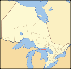
Location of Manitoulin District within Ontario
Coordinates: 45°46′N82°12′W / 45.767°N 82.200°W / 45.767; -82.200
Country Canada
Province Ontario
Region Northeastern Ontario
Created1888
Government
   MP Carol Hughes
   MPP Michael Mantha
Area
[1]
  Land3,107.12 km2 (1,199.67 sq mi)
Population
 (2016) [1]
  Total13,255
  Density4.3/km2 (11/sq mi)
Time zone UTC-5 (Eastern (EST))
  Summer (DST) UTC-4 (EDT)
Postal code span
P0P
Area code 705
Seat Gore Bay

Manitoulin District is a district in Northeastern Ontario within the Canadian province of Ontario. It was created in 1888 from part of the Algoma District. The district seat is in Gore Bay.

Contents

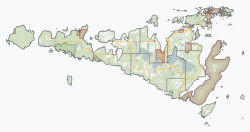
It comprises Manitoulin Island primarily, as well as a number of smaller islands surrounding it, such as Barrie, Cockburn, and Great La Cloche islands. Previously it included the municipality of Killarney on the mainland, until this was transferred to Sudbury District in the late 1990s. Subsequently, more mainland portions were added to Killarney and these, together with Unorganized Mainland Manitoulin District, were also transferred to Sudbury District in 2006, about 1,600 square kilometres (600 sq mi) in all. [2]

Geography

The district has an area of 3,107.13 square kilometres (1,199.67 sq mi), [1] making it the smallest district in Ontario. It is in the northern part of Lake Huron, separated from the mainland by the North Channel to the north and by the Georgian Bay to the east.

Islands included within the district are: [3]

Subdivisions

Towns

Gore Bay Gore Bay Manitoulin.JPG
Gore Bay
Name of TownPopulationRef.
Gore Bay 867
Northeastern Manitoulin and the Islands 2,706

Townships

Name of TownshipPopulationRef.
Assiginack 1,014
Billings 603
Burpee and Mills 343
Central Manitoulin 2,084
Cockburn Island 0
Gordon/Barrie Island 490
Tehkummah 436

Unorganized areas

Name of AreaPopulationRef.
Manitoulin, Unorganized, Mainland (dissolved in 2006)5
Manitoulin, Unorganized, West Part, includes these two geographic townships (each served by its own, separate local services board): 168

First Nations reserves

Name of ReservePopulationRef.
M'Chigeeng (West Bay) 939
Sheguiandah 154
Sheshegwaning 118
Aundeck Omni Kaning 365
Whitefish River 487
Wikwemikong 2,592
Zhiibaahaasing (Cockburn Island) 55

Communities

Demographics

As a census division in the 2021 Census of Population conducted by Statistics Canada, the Manitoulin District had a population of 13,935 living in 6,144 of its 9,302 total private dwellings, a change of 5.1% from its 2016 population of 13,255. With a land area of 3,073.54 km2 (1,186.70 sq mi), it had a population density of 4.5/km2 (11.7/sq mi) in 2021. [4]

Canada census – Manitoulin community profile
2021 2016 2011
Population13,935 (+5.1% from 2016)13,255 (1.6% from 2011)13,048 (3.3% from 2006)
Land area3,073.54 km2 (1,186.70 sq mi)3,107.11 km2 (1,199.66 sq mi)
Population density4.5/km2 (12/sq mi)4.2/km2 (11/sq mi)
Median age51.6 (M: 50.8, F: 52.0)46.6 (M: 46.2, F: 47.1)
Private dwellings9,302 (total)  6,144 (occupied)9,537 (total) 9281 (total) 
Median household income$63,600
Notes: 2006 population adjusted for 2011 boundaries is 12,632.
References: 2021 [5] 2016 [6] 2011 [1] earlier [7] [8]

Services

Like the other districts of Northern Ontario, the Manitoulin District does not have a county or regional municipality tier of government. All services in the district are provided either by the individual municipalities or directly by the provincial government. Services are provided jointly with the Sudbury District from its district seat in Espanola.

Media

The district is served by two weekly community newspapers, the Manitoulin Expositor in Little Current and the Manitoulin West Recorder in Gore Bay; the papers are sister publications both owned and operated by the McCutcheon family.

The district is served by the commercial radio stations CFRM-FM and CHAW-FM, the First Nations community radio station CHYF-FM, and the Elliot Lake-based commercial radio station CKNR-FM. It is otherwise primarily served by media from Sudbury, including the Sudbury Star and CTV Northern Ontario.

Highways

King's Highways

Secondary Highways

See also

Related Research Articles

<span class="mw-page-title-main">Killarney, Ontario</span> Municipality in Ontario, Canada

Killarney is a municipality located on the northern shore of Georgian Bay in the Sudbury District of Ontario, Canada. Killarney is commonly associated with Killarney Provincial Park, which is a large wilderness park located to the east of the townsite which occupies much of the municipality's expanded boundary. In addition to the community of Killarney itself, the communities of Hartley Bay and Bigwood, and the ghost towns of French River, Collins Inlet and Key Harbour, are also located within the municipal boundaries. The eastern end of the La Cloche Mountain Range is also located within the municipality of Killarney.

<span class="mw-page-title-main">Nickel Belt (federal electoral district)</span> Federal electoral district in Ontario, Canada

Nickel Belt is one of two federal electoral districts serving the city of Greater Sudbury, Ontario, Canada. It has been represented in the House of Commons of Canada since 1953.

<span class="mw-page-title-main">Timiskaming District</span> District in Ontario, Canada

Timiskaming is a district and census division in Northeastern Ontario in the Canadian province of Ontario. The district was created in 1912 from parts of Algoma, Nipissing, and Sudbury districts. In 1921, Cochrane District was created from parts of this district and parts of Thunder Bay District.

<span class="mw-page-title-main">Algoma District</span> District in Ontario, Canada

Algoma District is a district and census division in Northeastern Ontario in the Canadian province of Ontario.

<span class="mw-page-title-main">Espanola, Ontario</span> Town in Ontario, Canada

Espanola is a town in Northern Ontario, Canada, in the Sudbury District. It is situated on the Spanish River, approximately 70 kilometres (43 mi) west of downtown Sudbury, and just south of the junction of Highway 6 and Highway 17. The town is where the first experimental rules for the sport of ringette were created in 1963 by Mirl Arthur "Red" McCarthy using a group of local high school girls. Today, Espanola is considered "The Home of Ringette" while North Bay, Ontario, is considered the "Birthplace of Ringette" though the title of "birthplace of ringette" is often shared by both.

<span class="mw-page-title-main">Northeastern Manitoulin and the Islands</span> Town in Ontario, Canada

Northeastern Manitoulin and the Islands is a municipality with town status in Manitoulin District in Northeastern Ontario, Canada, approximately 30 kilometres (19 mi) south of Espanola. Its main town is Little Current, located on the northeast side of Manitoulin Island. However, its territory also includes most of the small islands surrounding Manitoulin, even those at the far western end of Manitoulin.

<span class="mw-page-title-main">Georgian Bay, Ontario</span> Township in Ontario, Canada

The Township of Georgian Bay is an area municipality of the District Municipality of Muskoka, in south-central Ontario, Canada. It is located on the Severn River, where it empties into the eponymous Georgian Bay. The municipal offices are at Port Severn.

<span class="mw-page-title-main">Sudbury District</span> District in Ontario, Canada

The Sudbury District is a district in Northeastern Ontario in the Canadian province of Ontario. It was created in 1894 from townships of eastern Algoma District and west Nipissing District.

<span class="mw-page-title-main">Seguin, Ontario</span> Township in Ontario, Canada

Seguin is a township in central Ontario, Canada, in the District of Parry Sound.

<span class="mw-page-title-main">Nipissing District</span> District in Ontario, Canada

Nipissing District is a district in Northeastern Ontario in the Canadian province of Ontario. It was created in 1858. The district seat is North Bay.

<span class="mw-page-title-main">Algoma—Manitoulin—Kapuskasing (federal electoral district)</span> Federal electoral district in Ontario, Canada

Algoma—Manitoulin—Kapuskasing is a federal electoral district in Ontario, Canada, that has been represented in the House of Commons of Canada since 2004. The area was represented by the riding of Algoma from 1867 to 1904 and from 1968 to 1996 and then by Algoma—Manitoulin from 1996 to 2004.

<span class="mw-page-title-main">French River, Ontario</span> Municipality in Ontario, Canada

French River, also known as Rivière-des-Français, is a municipality in the Canadian province of Ontario, in the Sudbury District. The municipality had a population of 2,662 in the Canada 2016 Census. It was formed in 1999 through the merger of the Township of Cosby, Mason and Martland and surrounding unincorporated portions of the Unorganized North Sudbury District. It was named after the French River, which flows through the municipality.

<span class="mw-page-title-main">Central Manitoulin</span> Township in Ontario, Canada

Central Manitoulin is a township in the Canadian province of Ontario. It is located on Manitoulin Island and in Manitoulin District.

<span class="mw-page-title-main">North Channel (Ontario)</span>

The North Channel is the body of water along the north shore of Lake Huron, in the Canadian province of Ontario. It stretches approximately 160 nautical miles (300 km) and is bordered on the east by Georgian Bay, on the west by the St. Marys River, to the north by the eastern Algoma District and part of the Sudbury District, and to the south by the islands of Manitoulin, Cockburn, Drummond and St. Joseph. At its widest point it is over 30 km wide.

<span class="mw-page-title-main">Assiginack</span> Township in Ontario, Canada

Assiginack is a township in the Canadian province of Ontario, located on Manitoulin Island. An Ontario Historical Plaque was built on the grounds of the Assiginack Museum by the province to commemorate the Manitoulin Treaties' role in Ontario's heritage.

<span class="mw-page-title-main">Cockburn Island (Ontario)</span> Township municipality in Ontario, Canada

Cockburn Island is an island and township municipality in the Canadian province of Ontario, located in the Manitoulin District. It is separated from the westernmost point of Manitoulin Island by the Mississagi Strait, and from Michigan's Drummond Island by the False Detour Channel. The island is incorporated as and coterminous with the municipal Township of Cockburn Island.

Unorganized South East Algoma District is an unorganized area in the Canadian province of Ontario, comprising a small unincorporated portion in the southeasternmost corner of the Algoma District. It comprises a small strip of land which lies between the territory of the Sagamok First Nation and the Algoma District's boundary with the Sudbury District, as well as several small islands within the North Channel of Lake Huron, such as Eagle, Fréchette, Fox, Hotham, Middleton, North and South Benjamin Islands.

Unorganized Mainland Manitoulin was an unorganized area in the Canadian province of Ontario, encompassing the small mainland portion of the Manitoulin District which was not part of the municipality of Killarney. It was dissolved and annexed into Killarney in 2006.

<span class="mw-page-title-main">Rainbow Country</span> Local Services Board in Ontario, Canada

Rainbow Country is a local services board in the Canadian province of Ontario. It encompasses and provides services to the communities of Whitefish Falls and Willisville in the Unorganized North Sudbury District and Birch Island and McGregor Bay in the Manitoulin District.

<span class="mw-page-title-main">Gordon/Barrie Island</span> Municipality in Ontario, Canada

The Municipality of Gordon/Barrie Island is a township in Manitoulin District in north central Ontario, Canada. It was formed on January 1, 2009, upon the amalgamation of the townships of Gordon and Barrie Island.

References

  1. 1 2 3 4 "2011 Community Profiles". 2011 Canadian Census . Statistics Canada. March 21, 2019. Retrieved 2012-03-19.
  2. "Annual changes to census subdivision codes, names and types, between 2006 and 2011, by province and territory, and by year". Standard Geographical Classification (SGC) 2011. Statistics Canada. Retrieved 2012-02-22.
  3. Geomatics Office, Ministry of Transportation (2008). Ontario, Canada, 2008/2009 official road map (2008-2009 ed.). St. Catharines, Ont.: Geomatics Office. ISBN   9781424955435.
  4. "Population and dwelling counts: Canada and census divisions". Statistics Canada. February 9, 2022. Retrieved April 2, 2022.
  5. "2021 Community Profiles". 2021 Canadian Census . Statistics Canada. February 4, 2022. Retrieved 2023-10-19.
  6. "2016 Community Profiles". 2016 Canadian Census . Statistics Canada. August 12, 2021.
  7. "2006 Community Profiles". 2006 Canadian Census . Statistics Canada. August 20, 2019.
  8. "2001 Community Profiles". 2001 Canadian Census . Statistics Canada. July 18, 2021.