Thunder Bay District

Last updated
Thunder Bay District
Map of Ontario THUNDER BAY.svg
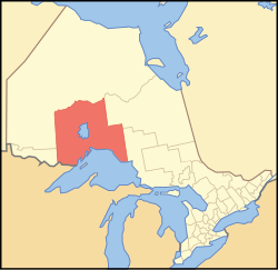
Location of Thunder Bay District in Ontario
Coordinates: 50°N088°W / 50°N 88°W / 50; -88
CountryCanada
Province Ontario
Region Northwestern Ontario
Created1871
Government
   MPs Carol Hughes (NDP)
Patty Hajdu (Liberal)
Don Rusnak (Liberal)
   MPPs Michael Gravelle (OLP)
Michael Mantha (NDP)
Judith Monteith-Farrell (NDP)
Area
[1]
  Land103,719.51 km2 (40,046.33 sq mi)
Elevation
[2]
220 m (720 ft)
Highest elevation
640 m (2,100 ft)
Lowest elevation
183 m (600 ft)
Population
 (2016) [3]
  Total146,048
  Density1.4/km2 (4/sq mi)
Time zones
East of 90° west UTC-05:00 (Eastern)
  Summer (DST) UTC-04:00 (EDT)
West of 90° west UTC-06:00 (Central)
  Summer (DST) UTC-05:00 (CDT)
Postal code span
Area code 807
Largest communities [4] Thunder Bay (109,140)
Oliver Paipoonge (5,757)
Greenstone (4,906)
The eponymous Thunder Bay Thunder Bay.jpg
The eponymous Thunder Bay

Thunder Bay District is a district and census division in Northwestern Ontario in the Canadian province of Ontario. The district seat is Thunder Bay.

Contents

In 2016, the population was 146,048. The land area is 103,719.51 square kilometres (40,046.33 sq mi); the population density was 1.4 per square kilometre (3.6/sq mi). [1] Most of the district (93.5%) is unincorporated and part of the Unorganized Thunder Bay District.

History

Thunder Bay District was created in 1871 by provincial statute from the western half of Algoma District, named after a large bay on the north shore of Lake Superior. Its northern and western boundaries were uncertain until Ontario's right to Northwestern Ontario was determined by the Judicial Committee of the Privy Council. [5] Until about 1902 it was often called Algoma West from the name of the provincial constituency established in 1885.

The following districts include areas that were formerly part of Thunder Bay District:

Subdivisions

Municipalities

First Nations and their Indian Reserves

Unorganized areas

Demographics

Thunder Bay District
Historical populations
YearPop.±%
1996 157,619    
2001 150,860−4.3%
2006 149,063−1.2%
2011 146,057−2.0%
2016 146,048−0.0%
[6] [1] [3]

As a census division in the 2021 Census of Population conducted by Statistics Canada, the Thunder Bay District had a population of 146,862 living in 64,601 of its 72,510 total private dwellings, a change of 0.6% from its 2016 population of 146,048. With a land area of 102,895.48 km2 (39,728.17 sq mi), it had a population density of 1.4/km2 (3.7/sq mi) in 2021. [7]

Canada census – Thunder Bay District community profile
2016 2011
Population146,048 (0.0% from 2011)146,057 (−2.0% from 2006)
Land area103,722.82 km2 (40,047.60 sq mi)
Population density1.4/km2 (3.6/sq mi)
Median age45.0 (M: 44.0, F: 45.9)
Private dwellings72,551 (total) 71,235 (total) 
Median household income$68,062
Notes: *Excludes census data for incompletely enumerated Indian reserves.
References: 2016 [3] 2011 [1] earlier [8] [9]

Further reading

See also

Related Research Articles

<span class="mw-page-title-main">Algoma District</span> District in Ontario, Canada

Algoma District is a district and census division in Northeastern Ontario in the Canadian province of Ontario.

<span class="mw-page-title-main">Bruce County</span> County in Ontario, Canada

Bruce County is a county in Southwestern Ontario, Canada. It has eight lower-tier municipalities with a total 2016 population of 66,491. It is named for James Bruce, 8th Earl of Elgin and 12th Earl of Kincardine, the sixth Governor General of the Province of Canada. The Bruce name is also linked to the Bruce Trail and the Bruce Peninsula.

<span class="mw-page-title-main">Greenstone, Ontario</span> Municipality in Ontario, Canada

Greenstone is a single-tier municipality in the Canadian province of Ontario with a population of 4,636 according to the 2016 Canadian census. It stretches along Highway 11 from Lake Nipigon to Longlac and covers 2,767.19 km2 (1,068.42 sq mi).

<span class="mw-page-title-main">Cochrane District</span> District in Ontario, Canada

Cochrane District is a district and census division in Northeastern Ontario in the Canadian province of Ontario. It was created in 1921 from parts of Timiskaming and Thunder Bay districts.

<span class="mw-page-title-main">Lake Nipigon</span> Lake in Ontario, Canada

Lake Nipigon is part of the Great Lakes drainage basin. It is the largest lake entirely within the boundaries of the Canadian province of Ontario.

<span class="mw-page-title-main">Thunder Bay—Superior North (federal electoral district)</span> Federal electoral district in Ontario, Canada

Thunder Bay—Superior North is a federal electoral district in Ontario, Canada, that has been represented in the House of Commons of Canada since 1976.

First Nations in Ontario constitute many nations. Common First Nations ethnicities in the province include the Anishinaabe, Haudenosaunee, and the Cree. In southern portions of this province, there are reserves of the Mohawk, Cayuga, Onondaga, Oneida, Seneca and Tuscarora.

<span class="mw-page-title-main">Nipigon</span> Township in Ontario, Canada

Nipigon is a township in Thunder Bay District, Northwestern Ontario, Canada, located along the west side of the Nipigon River and south of the small Helen Lake running between Lake Nipigon and Lake Superior. Lake Nipigon is located approximately 25 kilometres (16 mi) north of Nipigon. Located at latitude 49.0125° N, Nipigon is the northernmost community on the Great Lakes.

Aroland First Nation is a Ojibwa, Oji-Cree and cree First Nation within the Nishnawbe Aski Nation Territory and a signatory to Treaty 9, located in the Thunder Bay District approximately 20 kilometres west of Nakina. Aroland First Nation, has Indian reserve status, though the settlement itself is not a reserve. The Aroland First Nation is also a member of the Matawa First Nations Tribal Council.

The Robinson Treaties are two treaties signed between the Ojibwa chiefs and the Crown in 1850 in the Province of Canada. The first treaty involved Ojibwa chiefs along the north shore of Lake Superior, and is known as the Robinson Superior Treaty. The second treaty, signed two days later, included Ojibwa chiefs from along the eastern and northern shores of Lake Huron, and is known as the Robinson Huron Treaty. The Wiikwemkoong First Nation did not sign either treaty, and their land is considered "unceded".

The Ojibway Nation of Saugeen is an Ojibwa First Nation in the Canadian province of Ontario. The Nation is located in the Thunder Bay District, approximately 20 kilometres northwest of Savant Lake. In December, 2007, its total registered population was 206, of which the on-reserve population was 72. The community maintains strong ties with Mishkeegogamang First Nation

Lac La Croix First Nation is a Saulteaux First Nation band government who reside in the Rainy River District of northwestern Ontario, Canada, along the Ontario-Minnesota border. It is approximately 200 km northwest of Thunder Bay, Ontario. As of January 2008, the First Nation had a registered population of 398 people, of which their on-Reserve population was 273.

<span class="mw-page-title-main">Gull Bay First Nation</span> Indian reserve in Ontario, Canada

Gull Bay First Nation or Kiashke Zaaging Anishinaabek is an Anishinaabe (Ojibway) First Nation band government located in Thunder Bay District in northwestern Ontario, Canada. It is approximately 175 kilometres (109 mi) north of Thunder Bay, Ontario on Highway 527 on the western shore of Lake Nipigon. As of May 2010, the First Nation had a registered population of 1,149 people, including an on-Reserve population of 328.

<span class="mw-page-title-main">Biinjitiwaabik Zaaging Anishinaabek</span> Indian reserve in Ontario, Canada

The Biinjitiwaabik Zaaging Anishinaabek is an Ojibway First Nation band government in Northwestern Ontario, Canada. Their territory is located on the Rocky Bay 1 reserve in Greenstone, Ontario, bordering on the community of Macdiarmid. In October 2008, they had a total registered population of 678 people, of which 327 people lived on their own Indian reserve. The Nation is led by Chief Gladys Thompson. The council is a member of Nokiiwin Tribal Council, a Regional Chiefs' Council, and is member of Union of Ontario Indians, a Tribal Political Organization. The First Nation is also a member of Waaskiinaysay Ziibi Inc., an economic development corporation made up of five Lake Nipigon First Nations.

Nokiiwin Tribal Council is a non-profit Regional Chiefs' Council located in the Thunder Bay District, Ontario, Canada, serving five First Nations by providing advisory services and training which will enhance the overall management skills and opportunities of the area's First Nations.

<span class="mw-page-title-main">Biigtigong Nishnaabeg</span> Indian reserve in Ontario, Canada

Biigtigong Nishnaabeg is an Ojibway (Anishinaabe) First Nation on the northern shore of Lake Superior. It is sometimes referred to as Ojibways of the Pic River First Nation. Pic River is not a signatory to the Robinson Superior treaty; however, they did petition, starting in 1879, for a reserve and the request was subsequently granted. The community is located on the northern shore of Lake Superior at the mouth of the Pic River 316.6-hectare (782-acre) and is called Pic River 50. In November 2007, their total registered population was 964 people, of which their on-reserve population was 480.

Pic Mobert North is a First Nations reserve in Thunder Bay District, Ontario. It is one of two reserves of the Netmizaaggamig Nishnaabeg, alongside Pic Mobert South.

Pic Mobert South is a First Nations reserve in Thunder Bay District, Ontario. It is one of two reserves of the Netmizaaggamig Nishnaabeg, alongside Pic Mobert North.

References

  1. 1 2 3 4 "2011 Community Profiles". 2011 Canadian Census . Statistics Canada. March 21, 2019. Retrieved 2012-03-20.
  2. Highest point is 640m, located in Pukaskwa National Park. Thunder Bay is at 183m. 220 is an estimate
  3. 1 2 3 "2016 Community Profiles". 2016 Canadian Census . Statistics Canada. August 12, 2021. Retrieved 2019-07-13.
  4. Compilation of Northwestern Ontario's 2006 census data
  5. "Ontario-Manitoba Boundary Case". Archived from the original on 2012-10-04.
  6. Statistics Canada: 1996, 2001, 2006, 2011 census
  7. "Population and dwelling counts: Canada and census divisions". Statistics Canada. February 9, 2022. Retrieved April 2, 2022.
  8. "2006 Community Profiles". 2006 Canadian Census . Statistics Canada. August 20, 2019.
  9. "2001 Community Profiles". 2001 Canadian Census . Statistics Canada. July 18, 2021.