
Thunder Bay is a city in and the seat of Thunder Bay District, Ontario, Canada. It is the most populous municipality in Northwestern Ontario and the second most populous municipality in Northern Ontario; its population is 108,843 according to the 2021 Canadian Census. Located on Lake Superior, the census metropolitan area of Thunder Bay has a population of 123,258 and consists of the city of Thunder Bay, the municipalities of Oliver Paipoonge and Neebing, the townships of Shuniah, Conmee, O'Connor, and Gillies, and the Fort William First Nation.
Fort William was a city in Ontario, Canada, located on the Kaministiquia River, at its entrance to Lake Superior. It amalgamated with Port Arthur and the townships of Neebing and McIntyre to form the city of Thunder Bay in January 1970. Since then it has been the largest city in Northwestern Ontario. The city's Latin motto was A posse ad esse, featured on its coat of arms designed in 1900 by town officials, "On one side of the shield stands an Indian dressed in the paint and feathers of the early days; on the other side is a French voyageur; the center contains a grain elevator, a steamship and a locomotive, while the beaver surmounts the whole."

The Boundary Waters Canoe Area Wilderness is a 1,090,000-acre (4,400 km2) wilderness area within the Superior National Forest in the northeastern part of the US state of Minnesota under the administration of the U.S. Forest Service. A mixture of forests, glacial lakes, and streams, the BWCAW's preservation as a primitive wilderness began in the 1900s and culminated in the Boundary Waters Canoe Area Wilderness Act of 1978. It is a popular destination for canoeing, hiking, and fishing, and is one of the most visited wildernesses in the United States.
Port Arthur was a city in Northern Ontario, Canada, located on Lake Superior. In January 1970, it amalgamated with Fort William and the townships of Neebing and McIntyre to form the city of Thunder Bay.
The Boundary Waters–Canadian Derecho was an international derecho that occurred during the afternoon and evening hours of July 4 and the early morning hours of July 5, 1999. It traveled 1,300 miles (2,092 km) and lasted 22 hours.
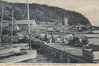
Jackfish is a ghost town in northern Ontario, Canada, located on the north shore of Lake Superior east of Terrace Bay.

King's Highway 61, commonly referred to as Highway 61 and historically known as the Scott Highway, is a provincially maintained highway in the Canadian province of Ontario. The 61-kilometre (38 mi) route connects the Pigeon River Bridge, where it crosses into the United States and becomes Minnesota State Highway 61, with a junction at Highway 11, Highway 17 and the Harbour Expressway in Thunder Bay. The highway forms part of the Lake Superior Circle Tour.

The Gunflint Range is an iron ore deposit in northern Minnesota in the United States and Northwestern Ontario, Canada. The range extends from the extreme northern portion of Cook County, Minnesota into the Thunder Bay District, Ontario.

The North Shore of Lake Superior runs from Duluth, Minnesota, United States, at the western end of the lake, to Thunder Bay and Nipigon, Ontario, Canada, in the north, to Sault Ste. Marie, Ontario in the east. The shore is characterized by alternating rocky cliffs and cobblestone beaches, with forested hills and ridges through which scenic rivers and waterfalls descend as they flow to Lake Superior.
The Port Arthur, Duluth and Western Railway (PADW) was a Canadian railway that operated in Northwestern Ontario.
The Whitefish River is a 45 km (28 mi) long river in Thunder Bay District in northwestern Ontario, Canada. It is in the Lake Superior drainage basin, is a tributary of the Kaministiquia River, and is in the centre of the Whitefish River Valley which is the location of several small settlements that grew along the Port Arthur, Duluth and Western Railway.
Gunflint Lodge is one of the oldest and the best known lodges on the Gunflint Trail in Minnesota, United States. It is located on Gunflint Lake, on the border of Ontario, Canada, and is open year-round.

James Whalen was a Canadian businessperson and entrepreneur based in Port Arthur, Ontario, now part of Thunder Bay, Ontario, with interests in the forest industries, shipbuilding, dredging, and towing. From a modest beginning as a timber contractor in the 1890s, he built an impressive business empire in various Great Lakes marine businesses. With the help of his brothers he was less successful in entering the competitive British Columbia pulp and paper business that went bankrupt in 1925.

Thomas Marks was an Irish-born Canadian businessman who served as the first mayor of Port Arthur, Ontario.
The Silver Mountain Station is a historic railway station located in the Thunder Bay District, Ontario. It sits at the intersection of Highway 588 and Highway 593. Now operated as a restaurant, it was constructed in 1907 as a major station along the Port Arthur, Duluth and Western Railway. It is also currently home to the Silver Mountain and Area Historical Society.

The North Lake is a former railway station located near North Lake, Thunder Bay District, Ontario. It lies close to La Verendrye Provincial Park and to the well known Boundary Waters Canoe Area Wilderness in the Boundary Waters between Canada and the United States. It was constructed in 1907 as a major station along the Port Arthur, Duluth and Western Railway.

The Paulson Mine is a former iron ore mine located in Cook County, Minnesota, United States, 53 kilometres north-west of Grand Marais, Minnesota near the end of the historic Gunflint Trail. The Port Arthur, Duluth and Western Railway was built to the mine in 1892 to access the ore, but both the mine and railway failed.

The Gunflint and Lake Superior Railroad (G&LS) is a defunct Minnesota logging railroad that operated in the Thunder Bay District of northwestern Ontario and in Cook County of northeastern Minnesota.

The Grand Portage–Pigeon River Border Crossing connects the cities of Grand Portage, Minnesota and Neebing, Ontario. It is the main route between the larger cities of Duluth, MN and Thunder Bay, ON.
Herman Finger was a lumberman who owned and operated various lumber companies that operated in Wisconsin, Minnesota, Ontario, Manitoba, and Saskatchewan. He also served as the first mayor of The Pas after its establishment in 1912.


