The Canadian Shield, also called the Laurentian Plateau, is a geologic shield, a large area of exposed Precambrian igneous and high-grade metamorphic rocks. It forms the North American Craton, the ancient geologic core of the North American continent. Glaciation has left the area with only a thin layer of soil, through which exposures of igneous bedrock resulting from its long volcanic history are frequently visible. As a deep, common, joined bedrock region in eastern and central Canada, the Shield stretches north from the Great Lakes to the Arctic Ocean, covering over half of Canada and most of Greenland; it also extends south into the northern reaches of the United States.
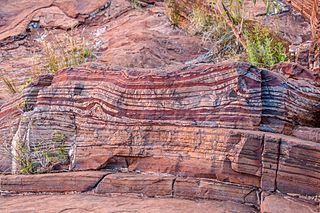
Banded iron formations are distinctive units of sedimentary rock consisting of alternating layers of iron oxides and iron-poor chert. They can be up to several hundred meters in thickness and extend laterally for several hundred kilometers. Almost all of these formations are of Precambrian age and are thought to record the oxygenation of the Earth's oceans. Some of the Earth's oldest rock formations, which formed about 3,700 million years ago (Ma), are associated with banded iron formations.

Chert is a hard, fine-grained sedimentary rock composed of microcrystalline or cryptocrystalline quartz, the mineral form of silicon dioxide (SiO2). Chert is characteristically of biological origin, but may also occur inorganically as a chemical precipitate or a diagenetic replacement, as in petrified wood.

The Mesabi Iron Range is a mining district in northeastern Minnesota following an elongate trend containing large deposits of iron ore. It is the largest of four major iron ranges in the region collectively known as the Iron Range of Minnesota. First described in 1866, it is the chief iron ore mining district in the United States. The district is located largely in Itasca and Saint Louis counties. It has been extensively worked since 1892, and has seen a transition from high-grade direct shipping ores through gravity concentrates to the current industry exclusively producing iron ore (taconite) pellets. Production has been dominantly controlled by vertically integrated steelmakers since 1901, and therefore is dictated largely by US ironmaking capacity and demand.
The Iron Range is collectively or individually a number of elongated iron-ore mining districts around Lake Superior in the United States and Canada. Much of the ore-bearing region lies alongside the range of granite hills formed by the Giants Range batholith. These cherty iron ore deposits are Precambrian in the Vermilion Range and middle Precambrian in the Mesabi and Cuyuna ranges, all in Minnesota. The Gogebic Range in Wisconsin and the Marquette Iron Range and Menominee Range in Michigan have similar characteristics and are of similar age. Natural ores and concentrates were produced from 1848 until the mid-1950s, when taconites and jaspers were concentrated and pelletized, and started to become the major source of iron production.
The Sudbury Basin, also known as Sudbury Structure or the Sudbury Nickel Irruptive, is a major geological structure in Ontario, Canada. It is the third-largest known impact crater or astrobleme on Earth, as well as one of the oldest. The crater was formed 1.849 billion years ago in the Paleoproterozoic era.
The Vermilion Range exists between Tower, Minnesota and Ely, Minnesota, and contains significant deposits of iron ore. Together with the Mesabi and Cuyuna Ranges, these three constitute the Iron Ranges of northern Minnesota. While the Mesabi Range had iron ore close enough to the surface to enable pit mining, mines had to be dug deep underground to reach the ore of the Vermilion and Cuyuna ranges. The Soudan mine was nearly 1/2 mile underground and required blasting of Precambrian sedimentary bedrock.
The Cuyuna Range is an inactive iron range to the southwest of the Mesabi Range, largely within Crow Wing County, Minnesota. It lies along a 68-mile-long (109 km) line between Brainerd, Minnesota, and Aitkin, Minnesota. The width ranges from 1 to 10 miles.

The Gunflint chert is a sequence of banded iron formation rocks that are exposed in the Gunflint Range of northern Minnesota and northwestern Ontario along the north shore of Lake Superior. The Gunflint Chert is of paleontological significance, as it contains evidence of microbial life from the Paleoproterozoic. The Gunflint Chert is composed of biogenic stromatolites. At the time of its discovery in the 1950s, it was the earliest form of life discovered and described in scientific literature, as well as the earliest evidence for photosynthesis. The black layers in the sequence contain microfossils that are 1.9 to 2.3 billion years in age. Stromatolite colonies of cyanobacteria that have converted to jasper are found in Ontario. The banded ironstone formation consists of alternating strata of iron oxide-rich layers interbedded with silica-rich zones. The iron oxides are typically hematite or magnetite with ilmenite, while the silicates are predominantly cryptocrystalline quartz as chert or jasper, along with some minor silicate minerals.
The Penokean orogeny was a mountain-building episode that occurred in the early Proterozoic about 1.86 to 1.83 billion years ago, in the area of Lake Superior, North America. The core of this orogeny, the Churchill Craton, is composed of terranes derived from the 1.86–1.81 Ga collision between the Superior and North Atlantic cratons. The orogeny resulted in the formation of the Nena and Arctica continents, which later merged with other continents to form the Columbia supercontinent. The name was first proposed by Blackwelder 1914 in reference to what is known as the Penokee Range, sometimes incorrectly called the Gogebic Range, in northern Michigan and Wisconsin.

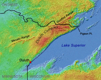
The Duluth Complex, the related Beaver Bay Complex, and the associated North Shore Volcanic Group are rock formations which comprise much of the basement bedrock of the northeastern part of the U.S. state of Minnesota in central North America. The Duluth and Beaver Bay complexes are intrusive rocks formed about 1.1 billion years ago during the Midcontinent Rift; these adjoin and are interspersed with the extrusive rocks of the North Shore Volcanic Group produced during that same geologic event. These formations are part of the Superior Upland physiographic region of the United States, which is associated with the Laurentian Upland of the Canadian Shield, the core of the North American Craton.
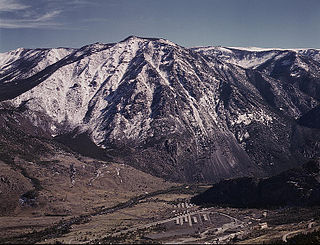
The Stillwater igneous complex is a large layered mafic intrusion (LMI) located in southern Montana in Stillwater, Sweet Grass and Park Counties. The complex is exposed across 30 miles (48 km) of the north flank of the Beartooth Mountain Range. The complex has extensive reserves of chromium ore and has a history of being mined for chromium. More recent mining activity has produced palladium and other platinum group elements.

The Temagami Greenstone Belt (TGB) is a small 2.7 billion year old greenstone belt in the Temagami region of Northeastern Ontario, Canada. It represents a feature of the Superior craton, an ancient and stable part of the Earth's lithosphere that forms the core of the North American continent and Canadian Shield. The belt is composed of metamorphosed volcanic rocks that range in composition from basalt to rhyolite. These form the east-northeast trend of the belt and are overlain by metamorphosed sedimentary rocks. They were created during several volcanic episodes involving a variety of eruptive styles ranging from passive lava eruptions to viscous explosive eruptions.
The Gogebic Range is an elongated area of iron ore deposits located within a range of hills in northern Michigan and Wisconsin just south of Lake Superior. It extends from Lake Namakagon in Wisconsin eastward to Lake Gogebic in Michigan, or almost 80 miles. Though long, it is only about a half mile wide and forms a crescent concave to the southeast. The Gogebic Range includes the communities of Ironwood in Michigan, plus Mellen and Hurley in Wisconsin.
The Rove Formation, is a sedimentary rock formation of Middle Precambrian age underlying the upper northeastern part of Cook County, Minnesota, United States, and extending into Ontario, Canada. It is the youngest of the many layers of sedimentary rocks which constitute the Animikie Group.

The Animikie Group is a geologic group composed of sedimentary and metasedimentary rock, having been originally deposited between 2,500 and 1,800 million years ago during the Paleoproterozoic era, within the Animikie Basin. This group of formations is geographically divided into the Gunflint Range, the Mesabi and Vermilion ranges, and the Cuyuna Range. On the map, the Animikie Group is the dark gray northeast-trending belt which ranges from south-central Minnesota, U.S., up to Thunder Bay, Ontario, Canada. The Gunflint Iron Range is the linear black formation labeled G, the Mesabi Iron Range is the jagged black linear formation labeled F, and Cuyuna Iron Range is the two black spots labeled E. The gabbro of the Duluth Complex, intruded during the formation of the Midcontinent Rift, separates the Mesabi and Gunflint iron ranges; it is shown by the speckled area wrapping around the western end of Lake Superior.

The geology of Ontario consists of the study of the rock formations in the most populated province of Canada. Ontario has some of the oldest rocks on Earth. It is made up of ancient Precambrian igneous and metamorphic rock and overlain by younger sedimentary rocks and soils.

The geology of Bosnia & Herzegovina is the study of rocks, minerals, water, landforms and geologic history in the country. The oldest rocks exposed at or near the surface date to the Paleozoic and the Precambrian geologic history of the region remains poorly understood. Complex assemblages of flysch, ophiolite, mélange and igneous plutons together with thick sedimentary units are a defining characteristic of the Dinaric Alps, also known as the Dinaride Mountains, which dominate much of the country's landscape.
The geology of Mississippi includes some deep igneous and metamorphic crystalline basement rocks from the Precambrian known only from boreholes in the north, as well as sedimentary sequences from the Paleozoic. The region long experienced shallow marine conditions during the tectonic evolutions of the Mesozoic and Cenozoic, as coastal plain sediments accumulated up to 45,000 feet thick, including limestone, dolomite, marl, anhydrite and sandstone layers, with some oil and gas occurrences and the remnants of Cretaceous volcanic activity in some locations.
The geology of Wisconsin includes Precambrian crystalline basement rock over three billion years old. A widespread marine environment during the Paleozoic flooded the region, depositing sedimentary rocks which cover most of the center and south of the state.