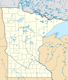
Grand Marais is a city and the county seat of Cook County, Minnesota, United States, of which it is the only municipality. It is on Lake Superior's North Shore. Grand Marais had a population of 1,337 at the 2020 census. Before it was settled by French Canadians and before Minnesota's statehood, it was inhabited by the Ojibwe.

Ely is a city in Saint Louis County, Minnesota, United States. The population was 3,268 at the 2020 census.

The Mesabi Iron Range is a mining district and mountain range in northeastern Minnesota following an elongate trend containing large deposits of iron ore. It is the largest of four major iron ranges in the region collectively known as the Iron Range of Minnesota. First described in 1866, it is the chief iron ore mining district in the United States. The district is located largely in Itasca and Saint Louis counties. It has been extensively worked since 1892, and has seen a transition from high-grade direct shipping ores through gravity concentrates to the current industry exclusively producing iron ore (taconite) pellets. Production has been dominantly controlled by vertically integrated steelmakers since 1901, and therefore is dictated largely by US ironmaking capacity and demand.

The Boundary Waters Canoe Area Wilderness comprises 1,090,000 acres (440,000 ha) of pristine forests, glacial lakes, and streams in the Superior National Forest. Located entirely within the U.S. state of Minnesota at the Boundary Waters, the wilderness area is under the administration of the United States Forest Service. Efforts to preserve the primitive landscape began in the 1900s and culminated in the Boundary Waters Canoe Area Wilderness Act of 1978. The area is a popular destination for canoeing, hiking, and fishing, and is the most visited wilderness in the United States.
The Iron Range is collectively or individually a number of elongated iron-ore mining districts around Lake Superior in the United States and Canada. Much of the ore-bearing region lies alongside the range of granite hills formed by the Giants Range batholith. These cherty iron ore deposits are Precambrian in the Vermilion Range and middle Precambrian in the Mesabi and Cuyuna ranges, all in Minnesota. The Gogebic Range in Wisconsin and the Marquette Iron Range and Menominee Range in Michigan have similar characteristics and are of similar age. Natural ores and concentrates were produced from 1848 until the mid-1950s, when taconites and jaspers were concentrated and pelletized, and started to become the major source of iron production.

The Duluth, Missabe and Iron Range Railway (DM&IR), informally known as the Missabe Road, was a railroad operating in northern Minnesota and Wisconsin that used to haul iron ore and later taconite to the Great Lakes ports of Duluth and Two Harbors, Minnesota. Control of the railway was acquired on May 10, 2004, by the Canadian National Railway (CN) when it purchased the assets of Great Lakes Transportation.

County State-Aid Highway 12 (CSAH 12), also known as the Gunflint Trail, or County Road 12 (CR 12), is a 57-mile (92 km) paved roadway and National Scenic Byway in Cook County, Minnesota, that begins in Grand Marais and ends at Saganaga Lake in the Boundary Waters Canoe Area Wilderness (BWCAW), near the U.S. border with Ontario. It provides access to many of the entry points in the BWCAW.
The Gunflint Range is an iron ore deposit in northern Minnesota in the United States and Northwestern Ontario, Canada. The range extends from the extreme northern portion of Cook County, Minnesota into the Thunder Bay District, Ontario.
The Cuyuna Range is an inactive iron range to the southwest of the Mesabi Range, largely within Crow Wing County, Minnesota. It lies along a 68-mile-long (109 km) line between Brainerd, Minnesota, and Aitkin, Minnesota. The width ranges from 1 to 10 miles.

The North Shore of Lake Superior runs from Duluth, Minnesota, United States, at the western end of the lake, to Thunder Bay and Nipigon, Ontario, Canada, in the north, to Sault Ste. Marie, Ontario in the east. The shore is characterized by alternating rocky cliffs and cobblestone beaches, with forested hills and ridges through which scenic rivers and waterfalls descend as they flow to Lake Superior.

The Seven Iron Men, also known as the Merritt brothers, were iron-ore pioneers in the Mesabi Range in northeastern Minnesota and the creation of the city that is now known as Mountain Iron. In the late 1800s, the Merritt family founded the largest iron mine in the world and initiated the consolidation of the American railway system into what would ultimately become the United States Steel Corporation. Their story was told, in part, by the book Seven Iron Men by Paul de Kruif. The book was first published in 1929.
The Gogebic Range is an elongated area of iron ore deposits located within a range of hills in northern Michigan and Wisconsin just south of Lake Superior. It extends from Lake Namakagon in Wisconsin eastward to Lake Gogebic in Michigan, or almost 80 miles. Though long, it is only about a half mile wide and forms a crescent concave to the southeast. The Gogebic Range includes the communities of Ironwood in Michigan, plus Mellen and Hurley in Wisconsin.
The Northeastern Minnesota Book Awards, or the NEMBA Awards, are awards presented annually for books that "substantially represent northeastern Minnesota in the areas of history, culture, heritage, or lifestyle."
Leeblain is a ghost town in the Canadian province of Ontario, located on the north shore of Gunflint Lake in the Thunder Bay District, partly within La Verendrye Provincial Park and next to the Boundary Waters Canoe Area Wilderness in the Boundary Waters between Canada and the United States.

Elcor is a ghost town, or more properly, an extinct town, in the U.S. state of Minnesota that was inhabited between 1897 and 1956. It was built on the Mesabi Iron Range near the city of Gilbert in St. Louis County. Elcor was its own unincorporated community before it was abandoned and was never a neighborhood proper of the city of Gilbert. Not rating a figure in the national census, the people of Elcor were only generally considered to be citizens of Gilbert. The area where Elcor was located was annexed by Gilbert when its existing city boundaries were expanded after 1969.

North Lake is a former railway station located near North Lake, Thunder Bay District, Ontario. It lies close to La Verendrye Provincial Park and to the well known Boundary Waters Canoe Area Wilderness in the Boundary Waters between Canada and the United States. It was constructed in 1907 as a major station along the Port Arthur, Duluth and Western Railway.

The Gunflint and Lake Superior Railroad (G&LS) is a defunct Minnesota logging railroad that operated in the Thunder Bay District of northwestern Ontario and in Cook County of northeastern Minnesota.
The Duluth, Missabe and Northern Railway (DM&N) was a railroad company in the U.S. state of Minnesota. It was one of the earliest iron ore hauling railroads of the area, said to have built the largest iron ore docks in the world, and later was one of the constituent railroads in the merger that formed the Duluth, Missabe and Iron Range Railway.
Cook County ISD 166, also known as Cook County Schools, is a school district headquartered in Grand Marais, Minnesota.
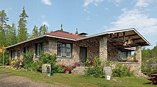
Chik Wauk Lodge, now Chik-Wauk Museum and Nature Center, is a historic building near the northern terminus of the Gunflint Trail northwest of Grand Marais, Minnesota, United States. It overlooks Saganaga Lake.