Armstrong, Thunder Bay District, Ontario

Last updated

Armstrong
compact rural community
unincorporated place
Armstrong ON.JPG
Canada Ontario location map 2.svg
Red pog.svg
Armstrong
Location in Ontario
Coordinates: 50°18′18″N89°02′31″W / 50.30500°N 89.04194°W / 50.30500; -89.04194 [1]
Country Canada
Province Ontario
District Thunder Bay
Time zone UTC-5 (Eastern Time Zone)
  Summer (DST) UTC-4 (Eastern Time Zone)
Postal Code
P0T 1A0
Area code 807

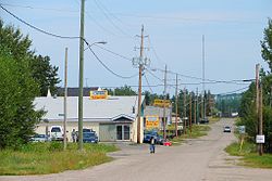
Armstrong is a compact rural community, unincorporated place, and divisional point on the Canadian National Railway transcontinental railway main line in the unorganized portion of Thunder Bay District in Northwestern Ontario, Canada. [1] The Whitesand First Nation's Armstrong Settlement is coterminous to this community. The Armstrong area is a popular tourist destination in the summer for fishing and hunting.

The community is not part of an incorporated municipality, but is administered by a local services board. [2]

Armstrong is accessible via Highway 527, which extends 235 kilometres (146 mi) north from Highway 11/17 near Thunder Bay. It takes about three hours to get to Armstrong by car from Thunder Bay.

According to the Canada 2016 Census, the community had a population of 193, down from 220 in 2011, a decrease of 12.3%. There are 186 dwellings of which 84 are occupied by usual residents. [3]

Canadian Forces Station Armstrong, located 1.1 miles (1.8 km) east of Armstrong, was closed in 1974. Later that year the base was sold to private owners and turned into a popular gathering area for the town that included a restaurant and bar, hotel, multiple apartments, garages, and a curling rink. The area, known as D&L, was closed and abandoned in 1993 and remains that way today.

The town of Armstrong currently has a public school, two restaurants, a Canada Post post office, a clinic, a Mini Mart gas station and motel, and the Armstrong General store (formally J&J General store 1961–2015).

Armstrong Airport is located 4.5 nautical miles (8.3 kilometres; 5.2 miles) east southeast of Armstrong.

The Via Rail Canadian train travels through and stops on request in Armstrong. [4]

Preceding station VIA Rail Canada simplified.svg Via Rail Following station
Collins
toward Vancouver
The Canadian Mud River
toward Toronto
Former services
Preceding station Canadian National Railway Following station
Onaping
toward Vancouver
Main Line Wagaming
toward Montreal
Aerial view of Armstrong, 2017 AerialArmstrong.jpg
Aerial view of Armstrong, 2017

Related Research Articles

<span class="mw-page-title-main">Thunder Bay</span> City in Ontario, Canada

Thunder Bay is a city in and the seat of Thunder Bay District, Ontario, Canada. It is the most populous municipality in Northwestern Ontario and the second most populous municipality in Northern Ontario; its population is 108,843 according to the 2021 Canadian Census. Located on Lake Superior, the census metropolitan area of Thunder Bay has a population of 123,258 and consists of the city of Thunder Bay, the municipalities of Oliver Paipoonge and Neebing, the townships of Shuniah, Conmee, O'Connor, and Gillies, and the Fort William First Nation.

<span class="mw-page-title-main">Nakina, Ontario</span> Unincorporated community in Ontario, Canada

Nakina is a community in the Town of Greenstone in the Thunder Bay District in Northern Ontario, Canada. It is approximately 60 kilometres (37 mi) north of Geraldton, located along the Canadian National Railway. The origins of the town were initially support of the railway, but its economy has evolved through lumber, pulp and paper, mining and tourism. It has a population of about 500 people.

<span class="mw-page-title-main">Parkdale, Toronto</span> Neighbourhood in Toronto, Ontario, Canada

Parkdale is a neighbourhood and former village in Toronto, Ontario, Canada, west of downtown. The neighbourhood is bounded on the west by Roncesvalles Avenue, on the north by the CP Rail line where it crosses Queen Street and Dundas Street. It is bounded on the east by Dufferin Street from Queen Street south, and on the south by Lake Ontario. The original village incorporated an area north of Queen Street, east of Roncesvalles from Fermanagh east to the main rail lines, today known as part of the Roncesvalles neighbourhood. The village area was roughly one square kilometre in area. The City of Toronto government extends the neighbourhood boundaries to the east, south of the CP Rail lines, east to Atlantic Avenue, as far south as the CN Rail lines north of Exhibition Place, the part south of King Street commonly known as the western half of Liberty Village neighbourhood.

<span class="mw-page-title-main">Wawa, Ontario</span> Municipality in Ontario, Canada

Wawa is a township in the Canadian province of Ontario in the Algoma District. Formerly known as the Township of Michipicoten, named after a nearby river of that name, the township was officially renamed in 2007 for its largest and best-known community of Wawa, located on the western shores of Wawa Lake.

<span class="mw-page-title-main">Ramara</span> Township in Ontario, Canada

Ramara is a lower-tier township municipality in Simcoe County, Ontario, Canada.

<span class="mw-page-title-main">Kenora District</span> District in Ontario, Canada

Kenora District is a district and census division in Northwestern Ontario, Canada. The district seat is the City of Kenora.

<span class="mw-page-title-main">Middlesex Centre</span> Municipality in Ontario, Canada

Middlesex Centre is a township in Middlesex County, in southwestern Ontario, Canada, north and west of London. The Corporation of the Township of Middlesex Centre formed on January 1, 1998, with the amalgamation of the former Townships of Delaware, Lobo, and London. It is part of the London census metropolitan area.

<span class="mw-page-title-main">Oliver Paipoonge</span> Municipality in Ontario, Canada

Oliver Paipoonge is a township in the Canadian province of Ontario, located directly west of the city of Thunder Bay. The municipality was formed on January 1, 1998, with the amalgamation of the former Township of Oliver and Township of Paipoonge. It contains several communities within its boundaries, including Baird, Carters Corners, Harstone, Kakabeka Falls, Lee, McCluskeys Corners, Millar, Murillo, Rosslyn, Slate River Valley, Stanley and Twin City. The remainder of the municipality is agricultural or rural.

<span class="mw-page-title-main">Marathon, Ontario</span> Town in Ontario, Canada

Marathon is a town in the Canadian province of Ontario, located in Thunder Bay District, on the north shore of Lake Superior north of Pukaskwa National Park.

<span class="mw-page-title-main">Nipigon</span> Township in Ontario, Canada

Nipigon is a township in Thunder Bay District, Northwestern Ontario, Canada, located along the west side of the Nipigon River and south of the small Helen Lake running between Lake Nipigon and Lake Superior. Lake Nipigon is located approximately 25 kilometres (16 mi) north of Nipigon. Located at latitude 49.0125° N, Nipigon is the northernmost community on the Great Lakes.

<span class="mw-page-title-main">Unorganized Thunder Bay District</span> Unorganized area in Ontario, Canada

Unorganized Thunder Bay District is an unorganized area in northwestern Ontario, Canada in Thunder Bay District. It comprises all parts of the district that are not part of an incorporated municipality or a First Nations reserve.

<span class="mw-page-title-main">Unorganized North Algoma District</span> Unorganized area in Ontario, Canada

Unorganized North Algoma District is an unorganized area in northeastern Ontario, Canada, comprising all areas in Algoma District, north of the Sault Ste. Marie to Elliot Lake corridor, which are not part of an incorporated municipality or a First Nation. It covers 44,077.03 km2 (17,018.24 sq mi) of land, and had a population of 6050 in 2021. Many of these communities were/are stations on the Algoma Central Railway or were logging/mining towns.

<span class="mw-page-title-main">Foleyet</span> Place in Ontario, Canada

Foleyet is an unincorporated community in the Unorganized North Part of Sudbury District in Northeastern Ontario, Canada, midway between Chapleau and Timmins on Highway 101. The town was created during the construction of the Canadian Northern Railway (CNR) through the area in the early years of the 20th century.

<span class="mw-page-title-main">Hornepayne</span> Township in Ontario, Canada

Hornepayne is a township of 980 people in the Algoma District of Ontario, Canada. The town was established in 1915 as Fitzback when the Canadian Northern Railway's transcontinental line was built through the area. It was renamed Hornepayne in 1920 after British financier Robert Horne-Payne. The municipality was originally named Wicksteed Township after the geographic township in which it is located. It was renamed Hornepayne, after its primary community, in 1986.

<span class="mw-page-title-main">Nairn and Hyman</span> Township in Ontario, Canada

Nairn and Hyman is a township in the Canadian province of Ontario. The township, located in the Sudbury District, borders on the southwestern city limits of Greater Sudbury west of the city's Walden district. The township had a population of 342 in the Canada 2016 Census.

<span class="mw-page-title-main">Hastings Highlands</span> Municipality in Ontario, Canada

Hastings Highlands is a township in the Canadian province of Ontario.

<span class="mw-page-title-main">Ear Falls</span> Township in Ontario, Canada

Ear Falls is a township located in Northwestern Ontario, Canada, on the banks of the English River, Lac Seul, Pakwash Lake and Wenesaga Lake. It is located along Highway 105, 100 kilometres (62 mi) north of Highway 17 and Vermilion Bay, about halfway between Highway 17 and Red Lake, or about 480 kilometres (300 mi) northwest of Thunder Bay.

Savant Lake is an unincorporated place and community in Unorganized Thunder Bay District in northwestern Ontario, Canada.

<span class="mw-page-title-main">Sleeman, Ontario</span> Community in Ontario, Canada

Sleeman is an unincorporated community located in Rainy River District in Northwestern Ontario, Canada. The town site is located in the center of Dawson. The original town site was along the Rainy River some 3 km south but in the early 1900s when the steam ships that traveled from Fort Frances to Rainy River and then to Rat Portage Via Lake of the Woods carrying Logs, Lumber, mail and other supplies stopped probably because the Canadian Northern Railway had finished its bridge and rail line from Winnipeg to International Falls and the docks of the great lakes located in Fort William and Port Arthur now known as Thunder Bay the town moved from the river to the rail line. The original store, coffee shop, post office building still stands today and has been renovated into a home. The town for many years held many stores, a large hotel, coffee shops, car dealership, school and a busy rail depot that served the Northern communities along Highway 621. A restaurant called The Green Onion was the local favourite. It was open 7 days a week and held indoor livery stables below for the travels from Morson who came to town to meet the trains, liquor was served here as well. Today there is only one business left, the Canada Postal outlet. Lowes Lumber, a local business for over 80 years went into bankruptcy and closed its doors in 2014. Only about 20 homes remain, even though an official town plan was made to accommodate many more. The rail siding was removed in 1993, the last of the CN hotel burned away in the late 1980s and the grocery store was demolished when the natural gas line was installed to serve the larger communities along Highway 11.

Redditt is an unincorporated community in Unorganized Kenora District in northwestern Ontario, Canada. It is on the MacFarlane River, and located at the northern terminus of Ontario Highway 658, 27 kilometres (17 mi) north of Kenora. Redditt is also the name of the surrounding geographic township that includes the community.

References

  1. 1 2 "Armstrong". Geographical Names Data Base . Natural Resources Canada . Retrieved 2014-03-24.
  2. "Local Services Boards - Armstrong". Northern Services Boards Act / Loi sur les régies des services publics du nord - R.R.O. 1990, Regulation 737. Canadian Legal Information Institute. 2009-11-04. Archived from the original on 2014-03-10. Retrieved 2009-11-10.
  3. "Census Profile, 2016 Census - Armstrong, Local service board [Designated place], Ontario and Ontario [Province]". 8 February 2017.
  4. "The Canadian westbound schedule" (PDF). Via Rail. Retrieved 2014-03-24.