Staunton, Ontario

Last updated
Staunton
Settlement
Country Canada
Province Ontario
Region Northwestern Ontario
District Thunder Bay
Part Thunder Bay, Unorganized
Elevation 425 m (1,394 ft)
Coordinates 50°14′30″N90°30′54″W / 50.24167°N 90.51500°W / 50.24167; -90.51500 Coordinates: 50°14′30″N90°30′54″W / 50.24167°N 90.51500°W / 50.24167; -90.51500
Timezone Central Time Zone (UTC-6)
 - summer (DST) Central Time Zone (UTC-5)
Postal code FSA P0T
Area code 807
Canada Ontario location map 2.svg
Red pog.svg
Location of Staunton in Ontario

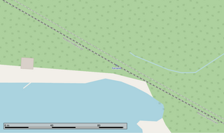
Staunton is an unincorporated place and railway point in Unorganized Thunder Bay District in northwestern Ontario, Canada. [1]

Unorganized Thunder Bay District Unorganized area in Ontario, Canada

Unorganized Thunder Bay District is an unorganized area in northwestern Ontario, Canada in Thunder Bay District. It comprises all parts of the district that are not part of an incorporated municipality or a First Nations reserve.

Thunder Bay District District in Ontario, Canada

Thunder Bay District is a district and census division in Northwestern Ontario in the Canadian province of Ontario. The district seat is Thunder Bay.

Northwestern Ontario Secondary region in Ontario, Canada

Northwestern Ontario is a secondary region of Northern Ontario which lies north and west of Lake Superior, and west of Hudson Bay and James Bay. It includes most of subarctic Ontario. Its western boundary is the Canadian province of Manitoba, which disputed Ontario's claim to the western part of the region. Ontario's right to Northwestern Ontario was determined by the Judicial Committee of the Privy Council in 1884 and confirmed by the Canada Act, 1889 of the Parliament of the United Kingdom. In 1912, the Parliament of Canada by the Ontario Boundaries Extension Act gave jurisdiction over the District of Patricia to Ontario, thereby extending the northern boundary of the province to Hudson Bay.

It is on the Canadian National Railway transcontinental main line, [2] between Savant Lake to the west and Flindt Landing to the east, has a passing track, and is passed but not served by Via Rail transcontinental Canadian trains.

Canadian National Railway railway company

Canadian National is a Canadian Class I freight railway headquartered in Montreal, Quebec that serves Canada and the Midwestern and Southern United States.

Transcontinental railroad contiguous network of railroad trackage that crosses a continental land mass with terminals at different oceans or continental borders

A transcontinental railroad is a contiguous network of railroad trackage that crosses a continental land mass with terminals at different oceans or continental borders. Such networks can be via the tracks of either a single railroad, or over those owned or controlled by multiple railway companies along a continuous route. Although Europe is crisscrossed by railways, the railroads within Europe are usually not considered transcontinental, with the possible exception of the historic Orient Express. Transcontinental railroads helped open up unpopulated interior regions of continents to exploration and settlement that would not otherwise have been feasible. In many cases they also formed the backbones of cross-country passenger and freight transportation networks.

The main line, or mainline in American English, of a railway is a track that is used for through trains or is the principal artery of the system from which branch lines, yards, sidings and spurs are connected. It generally refers to a route between towns, as opposed to a route providing suburban or metro services. For capacity reasons, main lines in many countries have at least a double track and often contain multiple parallel tracks. Main line tracks are typically operated at higher speeds than branch lines and are generally built and maintained to a higher standard than yards and branch lines. Main lines may also be operated under shared access by a number of railway companies, with sidings and branches operated by private companies or single railway companies.

Related Research Articles

Savant Lake Place in Ontario, Canada

Savant Lake is an unincorporated place and community in Unorganized Thunder Bay District in northwestern Ontario, Canada.

Hudson, Kenora District unincorporated place in Ontario, Canada

Hudson is an unincorporated place and community in the municipality of Sioux Lookout, Kenora District in northwestern Ontario, Canada. It is located on Lost Lake on the English River in the Nelson River drainage basin.

Amesdale, Ontario Place in Ontario, Canada

Amesdale is an unincorporated place and community in Unorganized Kenora District in northwestern Ontario, Canada. It is on the Canadian National Railway (CNR) transcontinental main line, between Niddrie to the west and Richan to the east, and is passed but not served by Via Rail transcontinental Canadian trains. It is also at the junction of a former CNR railway branch line through Ear Falls to Bruce Lake, Ontario that serviced the Griffith iron ore mine.

Rice Lake, Ontario Place in Ontario, Canada

Rice Lake is an unincorporated place and railway point in geographic Rice Township in Unorganized Kenora District in northwestern Ontario, Canada, 2.5 kilometres (1.6 mi) east of the border with the province of Manitoba.

Flindt Landing station railway station in Ontario, Canada

Flindt Landing railway station is located at Flindt Landing in Unorganized Thunder Bay District in northwestern Ontario, Canada. The station is on the Canadian National Railway transcontinental main line between Savant Lake to the west and Harvey to the east; it is used by Via Rail and served by transcontinental Canadian trains.

Richan station railway station in Ontario, Canada

Richan railway station is located in the community of Richan in Unorganized Kenora District in northwestern Ontario, Canada. The station is on the Canadian National Railway transcontinental main line, between Amesdale to the west and Millidge to the east, has a passing track, and is in use by Via Rail as a stop for transcontinental Canadian trains.

Red Lake Road station railway station in Ontario, Canada

Red Lake Road railway station is located in the community of Red Lake Road in Unorganized Kenora District, northwestern Ontario, Canada. The station is on the Canadian National Railway transcontinental main line, between Quibell to the west and Lash to the east, has a passing track, and is in use by Via Rail as a stop for transcontinental Canadian trains. Highway 105 passes to the east of the stop.

Farlane station railway station in Ontario, Canada

Farlane railway station is located in the community of Farlane in Unorganized Kenora District in northwestern Ontario, Canada. The station is on the Canadian National Railway transcontinental main line and is in use by Via Rail as a stop for transcontinental Canadian trains.

Redditt station railway station in Ontario, Canada

Redditt railway station is located in the community of Redditt in Unorganized Kenora District in northwestern Ontario, Canada. The station is on the Canadian National Railway transcontinental main line and is in use by Via Rail as a stop for transcontinental Canadian trains.

Flindt Landing in Ontario, Canada

Flindt Landing is an unincorporated place and railway point in Unorganized Thunder Bay District in northwestern Ontario, Canada.

Pelican Lake (Kenora District)

Pelican Lake is a lake in the Hudson Bay drainage basin in the town of Sioux Lookout and in Unorganized Kenora District in Kenora District, northwestern Ontario, Canada. It is about 8.5 kilometres (5.3 mi) long and 6.3 kilometres (3.9 mi) wide and lies at an elevation of 356 metres (1,168 ft). The town centre of Sioux Lookout is on the east shore of the lake, the railway point Pelican on the southwest, and the Canadian National Railway transcontinental main line crosses the lake and runs along the west shore.

Morgan, Ontario in Ontario, Canada

Morgan is an unincorporated place and railway point in Unorganized Kenora District in northwestern Ontario, Canada. It is on the Canadian National Railway transcontinental main line, between Lash to the west and Niddrie to the east, has a passing track, and is passed but not served by Via Rail transcontinental Canadian trains.

Lash, Ontario in Ontario, Canada

Lash is an unincorporated place and railway point in Unorganized Kenora District in northwestern Ontario, Canada. It is on the Canadian National Railway transcontinental main line, between Red Lake Road to the west and Morgan to the east, and is passed but not served by Via Rail transcontinental Canadian trains.

Niddrie, Ontario in Ontario, Canada

Niddrie is an unincorporated place and railway point in Unorganized Kenora District in northwestern Ontario, Canada. It is on the Canadian National Railway transcontinental main line, between Morgan to the west and Amesdale to the east, has a passing track, and is passed but not served by Via Rail transcontinental Canadian trains.

Richan in Ontario, Canada

Richan is an unincorporated place and community in Unorganized Kenora District in northwestern Ontario, Canada.

Millidge, Ontario in Ontario, Canada

Millidge is an unincorporated place and railway point in Unorganized Kenora District in northwestern Ontario, Canada.

Sunstrum, Ontario in Ontario, Canada

Sunstrum is an unincorporated place and railway point in Unorganized Kenora District in northwestern Ontario, Canada.

Taggart, Ontario in Ontario, Canada

Taggart is an unincorporated place and railway point in Unorganized Kenora District in northwestern Ontario, Canada.

Webster, Ontario in Ontario, Canada

Webster is an unincorporated place and important railway point in Unorganized Kenora District in northwestern Ontario, Canada. It is located on Webster Bay on Lost Lake on the English River, part of the Nelson River drainage basin.

Pelican, Ontario in Ontario, Canada

Pelican is an unincorporated settlement and railway point in the municipality of Sioux Lookout, Kenora District in northwestern Ontario, Canada. It is located just south of Pelican Lake on the English River, part of the Nelson River drainage basin.

References

  1. "Staunton". Geographical Names Data Base. Natural Resources Canada . Retrieved 2011-08-17.
  2. Map 13 (PDF) (Map). 1 : 1,600,000. Official road map of Ontario. Ministry of Transportation of Ontario. 2010-01-01. Retrieved 2011-08-17.