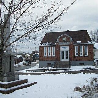
Stewiacke is a town located in southern Colchester County, Nova Scotia, Canada. The town was incorporated on August 30, 1906.

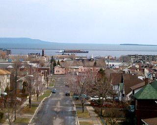
Thunder Bay is a city in, and the seat of, Thunder Bay District, Ontario, Canada. It is the most populous municipality in Northwestern Ontario with a population of 107,909 as of the Canada 2016 Census, and the second most populous in Northern Ontario after Greater Sudbury. Located on Lake Superior, the census metropolitan area of Thunder Bay has a population of 121,621, and consists of the city of Thunder Bay, the municipalities of Oliver Paipoonge and Neebing, the townships of Shuniah, Conmee, O'Connor, and Gillies, and the Fort William First Nation.

The Township of Langley is a district municipality immediately east of the City of Surrey in southwestern British Columbia, Canada. It extends south from the Fraser River to the U.S. border, and west of the City of Abbotsford. Langley Township is not to be confused with the City of Langley, which is adjacent to the township but politically is a separate entity. Langley is located in the eastern part of Metro Vancouver.

Timiskaming is a district and census division in Northeastern Ontario in the Canadian province of Ontario. The district was created in 1912 from parts of Algoma, Nipissing, and Sudbury districts. In 1921, Cochrane District was created from parts of this district and parts of Thunder Bay District.
Jasper is a specialized municipality in western Alberta, Canada. It is the commercial centre of Jasper National Park, located in the Canadian Rockies within the Athabasca River valley. Jasper is approximately 362 kilometres (225 mi) west of Edmonton and 290 kilometres (180 mi) north of Banff, Alberta, at the intersection of Highway 16 and Highway 93.

Hinton is a town in west-central Alberta, Canada.

Tooradin is a town in Victoria, Australia, 57 km south east from the central business district of Melbourne. Its local government area is the City of Casey. At the 2016 census, Tooradin had a population of 1,568.

Ramara is a lower-tier township municipality in Simcoe County, Ontario, Canada.

Kawaweogama Lake is a lake in the James Bay drainage basin in Unorganized Thunder Bay District in northwestern Ontario, Canada, about 35 kilometres (22 mi) east of the community of Savant Lake on Ontario Highway 516, 80 kilometres (50 mi) west of Armstrong on Ontario Highway 527, and 210 kilometres (130 mi) northwest of Thunder Bay. Except for the northwestern shore, the lake is encompassed by Brightsand River Provincial Park.

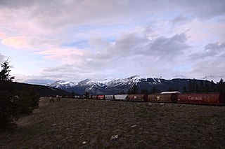
The Canadian is a transcontinental passenger train operated by Via Rail Canada with service between Union Station in Toronto, Ontario, and Pacific Central Station in Vancouver, British Columbia.

Upsala is an unincorporated community and geographic township in Thunder Bay District in northwestern Ontario, Canada. It is located along the Trans-Canada Highway, Highway 17, 142 kilometres (88 mi) west of Thunder Bay, part of the Unorganized Thunder Bay District.
Nipigon is a township in Thunder Bay District, Northwestern Ontario, Canada, located along the west side of the Nipigon River and south of the small Lake Helen running between Lake Nipigon and Lake Superior. Lake Nipigon is located approximately 25 kilometres (16 mi) north of Nipigon.

Telkwa is a village located along British Columbia Highway 16, nearly 15 kilometres (9 mi) southeast of the town of Smithers and 350 kilometres (220 mi) west of the city of Prince George, in northwest British Columbia, Canada.

Unorganized North Algoma District is an unorganized area in northeastern Ontario, Canada, comprising all areas in Algoma District, north of the Sault Ste. Marie to Elliot Lake corridor, which are not part of an incorporated municipality or a First Nation. It covers 44,077.03 km2 (17,018.24 sq mi) of land, and had a population of 5739 in 2016.

Ear Falls is a community and township located in Northwestern Ontario, Canada, on the right bank of the English River near the outlet of Lac Seul. It is located along Highway 105, 100 kilometres (62 mi) north of Highway 17 and Vermilion Bay, about halfway between Highway 17 and Red Lake, or about 480 kilometres (300 mi) northwest of Thunder Bay.
Savant Lake is an unincorporated place and community in Unorganized Thunder Bay District in northwestern Ontario, Canada.
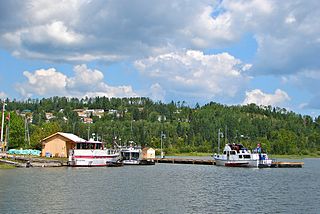
Transportation is essential to trade, which has always been the backbone of the economy of Thunder Bay, Ontario, Canada, beginning with Fort Kaministiquia in 1717. When the area was first settled its many waterways were used by the voyagers and Coureur des bois to trade their goods.

Sleeman is an unincorporated community located in Rainy River District in Northwestern Ontario, Canada. The town site is located in the center of Dawson. The original town site was along the Rainy River some 3 km south but in the early 1900s when the steam ships that traveled from Fort Frances to Rainy River and then to Rat Portage Via Lake of the Woods carrying Logs, Lumber, mail and other supplies stopped probably because the Canadian Northern Railway had finished its bridge and rail line from Winnipeg to International Falls and the docks of the great lakes located in Fort William and Port Arthur now known as Thunder Bay the town moved from the river to the rail line. The original store, coffee shop, post office building still stands today and has been renovated into a home. The town for many years held many stores, a large hotel, coffee shops, car dealership, school and a busy rail depot that served the Northern communities along Highway 621. A restaurant called The Green Onion was the local favourite, it was open 7 days a week and held indoor livery stables below for the travels from Morson who came to town to meet the trains, liquor was served here as well. Today there is only one business left, the Canada Postal outlet. Lowes Lumber a local business for over 80 years went into bankruptcy and closed its doors in 2014. Only about 20 homes remain, even though an official town plan was made to accommodate many more. The rail siding was removed in 1993, the last of the CN hotel burned away in the late 1980s and the grocery store was demolished when the natural gas line was installed to serve the larger communities along Highway 11.

Hudson Bay is a town in east-central Saskatchewan, Canada near the Manitoba border. The town is surrounded by the Rural Municipality of Hudson Bay No. 394.


