
The Indian River is a river in Renfrew County and Nipissing District in Eastern and Northeastern Ontario, Canada. It is in the Saint Lawrence River drainage basin, and is a left tributary of the Muskrat River.

The English River is a river in Kenora District and Thunder Bay District in Northwestern Ontario, Canada. It flows through Lac Seul to join the Winnipeg River at Tetu Lake as a right tributary. The river is in the Hudson Bay drainage basin, is 615 kilometres (382 mi) long and has a drainage basin of 52,300 square kilometres (20,200 sq mi). There are several hydroelectric plants on this river.
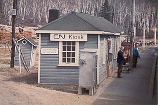
Kiosk is an unincorporated place and former railway point and community in geographic Pentland Township in the Unorganized South Part of Nipissing District in northeastern Ontario, Canada. Kiosk is surrounded by but not within Algonquin Provincial Park, for which it provides a road access point via Ontario Highway 630, and is located on Kioshkokwi Lake on the Amable du Fond River on the right bank of the outlet of that river from the lake and across the river from the unincorporated place of Coristine. The name "Kiosk" is an abbreviated form of the lake's name, which means "lake of many gulls".

Brent is a community on Cedar Lake on the Petawawa River in northern Algonquin Provincial Park, and is located in geographic Deacon Township in the Unorganized south part of Nipissing District in Northeastern Ontario, Canada.

English River is an unincorporated place on the border of geographic Corman Township, Kenora District and the Unorganized Part of Thunder Bay District in Northwestern Ontario, Canada. It was a Hudson's Bay Company trading post between 1894 and 1911, and is located where Ontario Highway 17 crosses the English River at its confluence with the Scotch River.
Tertiary Highway 802, commonly referred to as Highway 802, is a provincially maintained tertiary road in the Canadian province of Ontario, located in Thunder Bay District. The 13.7-kilometre (8.5 mi) route branches both north and south from Highway 11 to connect with the ghost town of Burchell Lake and the community of Kashabowie, respectively. The highway was established in 1962 at the peak of operations of the Burchell Lake mine. Although the mine and town were subsequently abandoned in 1966, the highway remains under provincial jurisdiction. The section that travels concurrently with Highway 11 forms part of the Trans-Canada Highway.

Kashabowie is an unincorporated place and Compact Rural Community in southwestern Thunder Bay District in Northwestern Ontario, Canada. It is on the Canadian National Railway Kashabowie Subdivision main line, built originally as the Canadian Northern Railway transcontinental main line, between the railway points of Planet to the west and Postans to the east, and has a passing siding.
Raith is a dispersed rural community and unincorporated area in geographic Golding Township in the Unorganized Part of Thunder Bay District in Northwestern Ontario, Canada.
Rib Lake is a long and narrow lake in the Town of Latchford and in the Municipality of Temagami in Northeastern Ontario, Canada, located about 9 kilometres (6 mi) southeast of the centre of the community of Latchford and 9 kilometres (6 mi) northeast of the community of Temagami North. The lake is in the Ottawa River drainage basin and is the main access for canoeists en route to Rib Mountain.

Summit Lake is a lake in geographic Shenango Township in the Unorganized North Part of Sudbury District in Northeastern Ontario, Canada. It is in the James Bay drainage basin about 29 kilometres (18 mi) northwest of the community of Foleyet on Highway 101, and 4 kilometres (2.5 mi) northwest of the Missonga and 6.7 kilometres (4.2 mi) southeast of the Oatland railway points on the Canadian National Railway transcontinental main line, which runs along the entire west side of the lake.
Pagwa is an unincorporated place and railway point in geographic Bicknell Township in Unorganized North Cochrane District in northeastern Ontario, Canada. It is named for the Pagwachuan River.
The Matawin River is a river in Thunder Bay District in Northwestern Ontario, Canada. It is in the Great Lakes Basin and is a right tributary of the Kaministiquia River.
The Oskondaga River is a river in Thunder Bay District in Northwestern Ontario, Canada. It is in the Great Lakes Basin and is a left tributary of the Shebandowan River. The river valley is paralleled by Ontario Highway 17, at this point part of the Trans-Canada Highway; and by both the Canadian Pacific Railway transcontinental main line, still in operation, and the Canadian National Railway Graham Subdivision main line, originally built as part of the National Transcontinental Railway, now abandoned.
Shebandowan Lakes is the name for the combined entity of three lakes — Upper Shebandowan Lake at the west, Middle Shebandowan Lake at the centre, and Lower Shebandowan Lake at the east — in the Unorganized Part of Thunder Bay District in Northwestern Ontario, Canada. The lakes are in the Great Lakes Basin, and Lower Shebandowan Lake is the source of the Shebandowan River.
The Swamp River is a river in Thunder Bay District in Northwestern Ontario, Canada. It is in the Great Lakes Basin and is a tributary of Shebandowan Lakes.
The Kashabowie River is a river in southwestern Thunder Bay District in Northwestern Ontario, Canada. It is in the Great Lakes Basin and is a tributary of the Shebandowan Lakes.
The Valentine River is a river in the Unorganized North Part of Cochrane District in northeastern Ontario, Canada. It is in the Moose River drainage basin, and is a tributary of Lac Pivabiska, the source of the Pivabiska River.
McLaren's Bay is a Dispersed rural community and unincorporated place in geographic Parkman Township in the Unorganized North Part of Nipissing District in Central Ontario, Canada. The community lies on the eponymous McLaren's Bay on the west shore of Lake Timiskaming, at the mouth of Opimika Creek. McLaren's Point is just north of the community.
René Brunelle Provincial Park is a provincial park in both the municipality of Moonbeam and geographic Gurney Township in Unorganized North Cochrane District, Cochrane District, in Northeastern Ontario, Canada. Established in 1957 and named after 1981 for René Brunelle, it is operated by Ontario Parks and has camping, hiking, swimming and other facilities on or near Remi Lake.

Potter Creek is a stream in the municipalities of Quinte West and Belleville in Central Ontario, Canada. It is a tributary of the Bay of Quinte and is thus in the Lake Ontario drainage basin.

