
A snowmobile, also known as a snowmachine, motor sled, motor sledge, skimobile, or snow scooter, is a motorized vehicle designed for winter travel and recreation on snow.

The Boundary Waters Canoe Area Wilderness comprises 1,090,000 acres (440,000 ha) of pristine forests, glacial lakes, and streams in the Superior National Forest. Located entirely within the U.S. state of Minnesota at the Boundary Waters, the wilderness area is under the administration of the United States Forest Service. Efforts to preserve the primitive landscape began in the 1900s and culminated in the Boundary Waters Canoe Area Wilderness Act of 1978. The area is a popular destination for canoeing, hiking, and fishing, and is the most visited wilderness in the United States.

Deer Lake is a town in the western part of the island of Newfoundland in the province of Newfoundland and Labrador, Canada.

Rondeau Provincial Park is the second oldest provincial park in Ontario, Canada, having been established with an order in council on 8 September 1894. The park is located in Southwestern Ontario, on an 8 km long crescentic sand spit extending into Lake Erie. Rondeau is home to the largest area of Carolinian forest in Canada, a long sand beach, a large marsh, approximately half of Rondeau Bay, campgrounds and a cottage community. The name of the park comes from the French words "ronde eau" or "round water" which describes the shape of the harbour sheltered by the peninsula.

Confederation Trail is the name for a 470 kilometre recreational rail trail system in the Canadian province of Prince Edward Island. It was developed in the 1990s, following the December 31, 1989, abandonment of all railway lines in the province by Canadian National Railway (CN).
Hike Ontario is a non-profit organization founded in 1974 devoted to promote hiking and walking activities in Ontario, Canada. Its headquarters are in Mississauga, and it was previously based at The Gate House of the Seneca College King Campus in King City.
The Vermont Association of Snow Travelers, Inc. (VAST) was founded in 1967 and is responsible for the organization of the sport of snowmobiling, maintaining and grooming over 5,000 miles of trails in the state of Vermont. Based in Berlin, Vermont, VAST is a private, non-profit organization with six full-time employees and one seasonal employee. Across the state, VAST includes more than 120 clubs, with over 24,000 members combined. Over 80% of the trails are on private land, and the clubs obtain landowner permission for trails on private property.

Rainy Lake is a freshwater lake with a surface area of 360 square miles (932 km2) that straddles the border between the United States and Canada. The Rainy River issues from the west side of the lake. Today it is harnessed to make hydroelectricity for US and Canadian locations. International Falls, Minnesota and the much smaller city of Ranier, Minnesota are situated opposite Fort Frances, Ontario, on either side of the Rainy River. Rainy Lake and Rainy River establish part of the boundary between the US state of Minnesota and the Canadian province of Ontario.
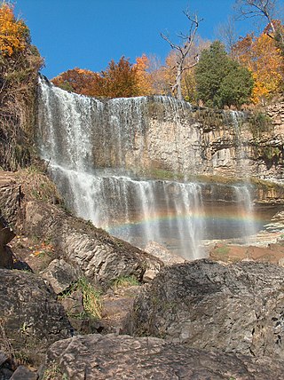
The Hamilton Conservation Authority maintains the greenspace, trails, parks and some attractions in Hamilton, Ontario, Canada.
Eabametoong, also known as Fort Hope or Eabamet Lake by Canada Post, is an Ojibwe First Nations band government in Kenora District, Ontario, Canada. Located on the shore of Eabamet Lake in the Albany River system, the community is located approximately 300 km (190 mi) northeast of Thunder Bay and is accessible only by airplane via Fort Hope Airport or water, or by winter/ice roads, which connect the community to the Northern Ontario Resource Trail. The Eabametoong First Nation Reserve is completely surrounded by territory of the Unorganized Kenora District.
The Wahnapitae First Nation is an Ojibway First Nation band government in the Canadian province of Ontario, who primarily reside on the 1,036-hectare (2,560-acre) Wahnapitae Indian Reserve No. 11 on the northwestern shore of Lake Wanapitei. The First Nation is a signatory to the Robinson-Huron Treaty of 1850 as the Tahgaiwenene's Band. The reserve had a resident population of 102 in the Canada 2011 Census; the First Nation also has approximately 200 further registered members who currently live off-reserve.
Redditt is an unincorporated community in Unorganized Kenora District in northwestern Ontario, Canada. It is on the MacFarlane River, and located at the northern terminus of Ontario Highway 658, 27 kilometres (17 mi) north of Kenora. Redditt is also the name of the surrounding geographic township that includes the community.

Aweres is a local services board in the Canadian province of Ontario. Located in the Algoma District, it encompasses and provides services to most of the geographic township of Aweres, including the communities of Island Lake and Heyden.

Four Mile Lake is a lake in the city of Kawartha Lakes in Central Ontario, Canada. The lake is 3.56 kilometres (2.21 mi) northeast of Coboconk, Ontario and 2.08 kilometres (1.29 mi) west of Burnt River. It is one of the Kawartha Lakes series of lakes and is in the Great Lakes Basin.
The Ontario Trails Council (OTC) is a charitable organization which promotes the management, use, preservation and development of recreational trails and trail based activity, in Ontario, Canada.

Conestogo Lake is an artificial lake on the Conestogo River in Wellington County in Southwestern Ontario, Canada. It is a reservoir with a flood control dam, and covers approximately 628 ha. 398 cottage lots are located around the lake.

The Cataraqui Trail is a 104-kilometre (65 mi) multi-use linear recreational rail trail in Eastern Ontario, Canada. The route passes by farmland, woods, lakes, and wetlands. The trail begins southwest of Smiths Falls, at a parking lot south of Ontario Highway 15 designated as kilometre zero.
The Prescott-Russell Recreational Trail (Trail) is a 72 kilometres (45 mi) long former rail trail in Prescott-Russell, Ontario, Canada, maintained by a non profit corporation. The trail begins at the Quebec border in the east, just outside of the village of Saint-Eugène and goes to the eastern boundary of the City of Ottawa, passing through the townships of East Hawkesbury, Champlain, The Nation, Alfred and Plantagenet, and Clarence-Rockland.
Great Blue Heron Provincial Park is a recreational park in the central region of the Canadian province of Saskatchewan in the boreal forest ecozone of Canada. It is adjacent to the eastern boundary of Prince Albert National Park, about 50 kilometres (31 mi) north of the city of Prince Albert. The provincial park was established in 2013 from two pre-existing provincial recreation sites – Emma Lake and Anglin Lake Recreation Sites – and the addition of a large tract of Crown land.
Matinenda Provincial Park is a provincial park in Algoma District, Ontario, Canada. It is located 15 kilometres (9.3 mi) north of the Town of Blind River. It is a large, elongated, irregularly shaped park, centered around Matinenda Lake.