Lambton County

Last updated
Lambton County
County of Lambton
Flag of Lambton County.gif
Logo of Lambton County, Ontario.svg
Map of Ontario LAMBTON.svg
Location of Lambton County
Coordinates: 42°54′N82°06′W / 42.900°N 82.100°W / 42.900; -82.100
CountryFlag of Canada (Pantone).svg Canada
ProvinceFlag of Ontario.svg  Ontario
Formed1849
County seat Wyoming [1]
Municipalities
List
Area
[2]
  Land2,999.93 km2 (1,158.28 sq mi)
Population
 (2021) [3]
  Total128,154
  Density42.7/km2 (111/sq mi)
Demonym Lambtoneer
Time zone UTC-5 (EST)
  Summer (DST) UTC-4 (EDT)
Website www.lambtononline.ca/

Lambton County is a county in Southwestern Ontario, Canada. It is bordered on the north by Lake Huron, which is drained by the St. Clair River, the county's western border and part of the Canada-United States border. To the south is Lake Saint Clair and Chatham-Kent. Lambton County's northeastern border follows the Ausable River and Parkhill Creek north until it reaches Lake Huron at the beach community of Grand Bend. The county seat is in the Town of Plympton-Wyoming.

Contents

The largest city in Lambton County is Sarnia, [4] which is located at the source of the St. Clair River at Lake Huron. The two Blue Water Bridges cross the river at Sarnia, connecting it to Port Huron, Michigan. The bridges are one of the busiest border crossings between the two countries. The river is also traversed by one passenger ferry further south, and a rail tunnel, also at Sarnia, runs underneath it. The CN rail tunnel accommodates double stacked rail cars. Along with Sarnia, the population centres in Lambton County are: Corunna, Petrolia, Grand Bend, Wyoming, Forest, and Watford.

Historical map that includes Lambton County (1875) Atlas of the Dominion. Counties of Middlesex, Elgin, Lambton. Province of Ontario. CTASC.jpg
Historical map that includes Lambton County (1875)

Lambton County started as a part of the District of Hesse. The district of Hesse included British territories west of Long Point (practically all of western Ontario). The district was later divided and renamed using English district names (Essex, Suffolk, Kent, etc.). Lambton was part of Kent county. In 1849 districts were abolished and the County of Lambton was formed. Lambton and Kent first shared the capital city of Sandwich (since renamed as Windsor, Ontario). In 1852 the partnership was dissolved and Lambton become a full county. It is named in honour of John Lambton, 1st Earl of Durham, who visited the area in the late 1830s. [5]

Subdivisions

Lambton County consists of 11 municipalities (in order of population):

Independent First Nation reserves

Independent of the County, but located within the Lambton census division, are three First Nations reserves:

Demographics

As a census division in the 2021 Census of Population conducted by Statistics Canada, Lambton County had a population of 128,154 living in 55,205 of its 60,322 total private dwellings, a change of 1.2% from its 2016 population of 126,638. With a land area of 2,999.93 km2 (1,158.28 sq mi), it had a population density of 42.7/km2 (110.6/sq mi) in 2021. [3]

Canada census – Lambton community profile
2021 2016 2011
Population128,154 (+1.2% from 2016)126,638 (0.3% from 2011)126,199 (-1.6% from 2006)
Land area2,999.93 km2 (1,158.28 sq mi)3,002.25 km2 (1,159.18 sq mi)3,002.07 km2 (1,159.11 sq mi)
Population density42.7/km2 (111/sq mi)42.2/km2 (109/sq mi)42.0/km2 (109/sq mi)
Median age46.4 (M: 44.8, F: 48.0)43.9 (M: 42.8, F: 44.8)
Private dwellings60,322 (total)  55,205 (occupied)54,480 (total) 58,243 (total) 
Median household income$83,000
Notes: Excludes census data for one or more incompletely enumerated Indian reserves
References: 2021 [6] 2016 [7] 2011 [8] earlier [9] [10]
Historical population
YearPop.±%
1996 126,829    
2001 123,611−2.5%
2006 124,600+0.8%
2011 124,623+0.0%
2016 123,399−1.0%
2021 128,154+3.9%
Statistics Canada: [3]

Economy

An oil well near Sarnia Oil well3419.jpg
An oil well near Sarnia

Total employment for Lambton County is 66,370. Of those, 9,760 (14.7%) are employed in manufacturing; 7,545 (11.4%) in retail trade; 5,080 (7.7%) in accommodation and food services; and 3,155 (4.8%) are employed in agriculture.[ citation needed ]

Petrochemical and refining is the largest manufacturing sector in Lambton County's economy. Established during World War II, Sarnia and the area along the St. Clair River is home to a major processing centre for oil from Alberta.

In late 2010 and early 2011 a number of companies announced plans to provide ethane from the Marcellus Shale in the United States to Lambton County industries, providing a potential new feedstock for the production of ethylene in Lambton County.

Lambton County is the site of North America's first drilled commercial oil well at Oil Springs in 1858.

Tourism is another important industry in Lambton County, especially along the lake and river. The community of Grand Bend and the Pinery Provincial Park are especially popular tourist destinations, attracting thousands of people each week throughout the summer to their long, uninterrupted beaches. The part of Lambton County along Lake Huron known as Lambton Shores depends almost entirely upon the seasonal industries of tourism and agriculture for its well-being. There are also popular conservation areas along the St. Clair River, and a conservation area named Rock Glen Falls near Arkona along the Ausauble River internationally known for its Devonian period fossils.

Lambton County has 2,346 farms with a total of 592,793 acres. The largest single use of farmland in Lambton is crop production, with 85% of total farmland reported as land in crops. Over the last 20 years, soybeans, wheat, and grain corn have accounted for over 80% of total area crop production in Lambton. The fourth and fifth leading crops are sugar beets and hay. Oats, barley and mixed grains are also produced. Top animal production includes dairy, beef, hog, and poultry. [11]

The Blue Water Bridges Blue Water Bridge.jpg
The Blue Water Bridges

Infrastructure

Highways

Emergency services

The County of Lambton Emergency Medical Services (EMS) provides land ambulance services to the residents of Lambton County. The County of Lambton EMS has stations in Brigden, Corunna, Forest, Grand Bend, Petrolia, Thedford, Watford, and two stations in Sarnia. Lambton EMS has ten ambulances and employs approximately 150 full- and part-time Primary Care Paramedics. [12]

Policing is provided by the Ontario Provincial Police (OPP), which has detachments in Grand Bend, Petrolia, Corunna, and Point Edward. The area of Kettle & Stony Point which is one of three native reservations in Lambton County, is policed by the Anishinabek Police Service (APS) but dispatched by the OPP. Walpole Island, another first nations reservation has its own police service, the Walpole Island Police Service. The remaining first nations reservation, Aamjiwnaang First Nation, which falls geographically within the City of Sarnia, is covered by the Sarnia Police Service.

Communities

See also

Related Research Articles

<span class="mw-page-title-main">Sarnia</span> City in Ontario, Canada

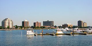
Sarnia is a city in Lambton County, Ontario, Canada. It had a 2021 population of 72,047, and is the largest city on Lake Huron. Sarnia is located on the eastern bank of the junction between the Upper and Lower Great Lakes where Lake Huron flows into the St. Clair River in the Southwestern Ontario region, which forms the Canada–United States border, directly across from Port Huron, Michigan.

<span class="mw-page-title-main">Walpole Island First Nation</span> Unceded territory in Ontario, Canada

Walpole Island is an island and First Nation reserve in southwestern Ontario, Canada, on the border between Ontario and Michigan in the United States. It is located in the mouth of the Saint Clair River on Lake Saint Clair, about 121 kilometres (75 mi) by road from Windsor, Ontario, and 124 kilometres (77 mi) from Detroit, Michigan.
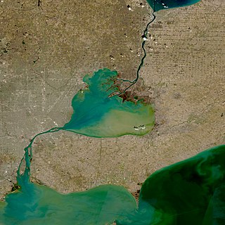
<span class="mw-page-title-main">St. Clair, Ontario</span> Township in Ontario, Canada

St. Clair is a township in southwestern Ontario, Canada, immediately south of Sarnia in Lambton County, along the eastern shores of the St. Clair River.

<span class="mw-page-title-main">Point Edward, Ontario</span> Village in Ontario, Canada

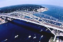
Point Edward is a village in the Canadian province of Ontario. Adjacent to the city of Sarnia in Lambton County, Point Edward sits opposite Port Huron, Michigan and is connected to it by the Blue Water Bridge, at the meeting point of the St. Clair River and Lake Huron. Formerly called Huron, it was renamed in 1860 to mark the visit by the then Prince of Wales, later Edward VII. Incorporated 1879. In the Canada 2016 Census, the population of Point Edward was 2,037, an increase of 0.1 percent from its 2011 population of 2,034.

<span class="mw-page-title-main">Southwestern Ontario</span> Secondary region in Ontario, Canada

Southwestern Ontario is a secondary region of Southern Ontario in the Canadian province of Ontario. It occupies most of the Ontario Peninsula bounded by Lake Huron, including Georgian Bay, to the north and northwest; the St. Clair River, Lake St. Clair, and Detroit River, to the west; and Lake Erie to the south. To the east, on land, Southwestern Ontario is bounded by Central Ontario and the Golden Horseshoe. The region had a population of 2,583,544 in 2016. It is sometimes further divided into "Midwestern Ontario" covering the eastern half of the area and the heart of Southwestern Ontario encompassing the western half of the region.

<span class="mw-page-title-main">Lambton—Kent—Middlesex (federal electoral district)</span> Federal electoral district in Ontario, Canada

Lambton—Kent—Middlesex is a federal electoral district in Ontario, Canada, that has been represented in the House of Commons of Canada since 1997.

<span class="mw-page-title-main">Sarnia—Lambton (federal electoral district)</span> Federal electoral district in Ontario, Canada

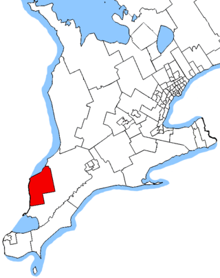
Sarnia—Lambton is a federal electoral district in Ontario, Canada, that has been represented in the House of Commons of Canada since 1968. It is located in the area of the city of Sarnia, in the southwest corner of the province of Ontario.

Lambton West was a federal electoral district represented in the House of Commons of Canada from 1883 to 1968. It was located in the province of Ontario. This riding was created from parts of Lambton riding.
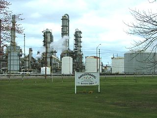
The Aamjiwnaang First Nation is an Anishinaabe (Ojibwe) First Nations Band located on reserve land by the St. Clair River in Ontario, Canada, three miles south of the southern tip of Lake Huron. The reserve is located across from the United States border from Port Huron, Michigan, and is a result of treaties that were negotiated with the Crown in the 1820s. There are approximately 2,000 band members with about 850 living on the reserve. Their heritage language is Ojibwe.

<span class="mw-page-title-main">Lambton Shores</span> Municipality in Ontario, Canada

Lambton Shores is a municipality in Lambton County, Ontario, Canada, that is on the southern shores of Lake Huron.

The St. Clair Parkway, historically referred to as the River Road, is a scenic parkway in the Canadian province of Ontario. It travels alongside the St. Clair River from west of Wallaceburg to Sarnia, a distance of 41.8 kilometres (26.0 mi). It formed a portion of the route of Highway 40 until it was bypassed by an inland route that opened in the mid-1970s. The St. Clair River Parkway Commission maintained the route from 1966 until 2006, when it was disbanded and responsibility over the parkway transferred to Chatham-Kent and Lambton County, both of which designate the route as County Road 33. The communities of Port Lambton, Sombra, Courtright, Mooretown, Corunna and Froomfield are located along the parkway, all early settlements of the 19th century.

<span class="mw-page-title-main">Plympton–Wyoming</span> Town in Ontario, Canada

Plympton–Wyoming is a town in the Canadian province of Ontario, located in Lambton County immediately east of Sarnia. It is the seat of the Lambton County Council.

<span class="mw-page-title-main">Lambton Kent District School Board</span> School board in Ontario, Canada

The Lambton Kent District School Board is the school board responsible for public education in Lambton County and Chatham-Kent, Ontario, Canada. Lambton and Kent Counties are made up of numerous small towns and communities situated in Southwestern Ontario, a geographic area surrounded by the Great Lakes.

King's Highway 21, commonly referred to as Highway 21, is a provincially maintained highway in the Canadian province of Ontario that begins at Highway 402 midway between Sarnia and London and ends at Highway 6, Highway 10 and Highway 26 in Owen Sound. The roadway is referred to as the Bluewater Highway because it remains very close to the eastern shoreline of Lake Huron.

<span class="mw-page-title-main">Warwick, Ontario</span> Township in Ontario, Canada

Warwick is a rural township in Lambton County, Ontario, Canada, with a population (2016) of 3,692.

<span class="mw-page-title-main">Brooke-Alvinston</span> Municipality in Ontario, Canada

Brooke-Alvinston is a township municipality in the Canadian province of Ontario, located within Lambton County. It was formed on January 1, 2001, when the Township of Brooke was amalgamated with the Village of Alvinston.

King's Highway 80, commonly referred to as Highway 80, was a provincially maintained highway in the Canadian province of Ontario. It travelled in an east–west direction south of Sarnia from Courtright to Strathburn. Beginning at the St. Clair Parkway near the shores of the St. Clair River, the route travelled 69.6 kilometres (43.2 mi), intersecting Highway 40, Highway 21 and Highway 79 before ending at Highway 2. In addition to the towns at either terminus, Highway 80 serviced the communities of Brigden, Glencoe and Alvinston. The entire route was and remains two lanes wide.

Elections were held in Lambton County, Ontario on October 22, 2018 in conjunction with municipal elections across the province.

<span class="mw-page-title-main">Corunna, Ontario</span> Community in St. Clair, Ontario, Canada

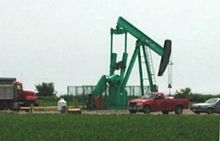
Corunna is an unincorporated community in St. Clair Township, Lambton County, Ontario, Canada. The site of the community was surveyed by William Beresford in 1823. The community is located approximately 13 kilometres (8.1 mi) south of Sarnia. The community experienced a significant population boom between the 1830s and 1850s, mainly attributed to Scotch-Irish immigration. The community serves as the location of Chemical Valley, a major petrochemical and plastics manufacturing facility.

Elections were held in Lambton County, Ontario on October 24, 2022, in conjunction with municipal elections across the province.

References

  1. "Contact Us". The Corporation of the County of Lambton. Retrieved August 6, 2019.
  2. "Census Profile, 2016 Census - Lambton, County (Census division), Ontario and Ontario (Province)". Canada 2016 Census . Statistics Canada . Retrieved 9 July 2017.
  3. 1 2 3 "Population and dwelling counts: Canada and census divisions". Statistics Canada. February 9, 2022. Retrieved April 2, 2022.
  4. "City of Sarnia - Overview" . Retrieved 9 July 2017.
  5. "The Man Who Gave Lambton Its Name". LambtonCounty.com. Retrieved 10 November 2018.
  6. "2021 Community Profiles". 2021 Canadian Census . Statistics Canada. February 4, 2022. Retrieved 2023-10-19.
  7. "2016 Community Profiles". 2016 Canadian Census . Statistics Canada. August 12, 2021. Retrieved 2017-07-09.
  8. "2011 Community Profiles". 2011 Canadian Census . Statistics Canada. March 21, 2019. Retrieved 2012-03-28.
  9. "2006 Community Profiles". 2006 Canadian Census . Statistics Canada. August 20, 2019.
  10. "2001 Community Profiles". 2001 Canadian Census . Statistics Canada. July 18, 2021.
  11. "Agriculture". Sarnia-Lambton Economic Partnership. Retrieved 10 November 2018.
  12. "Emergency Medical Services". Corporation of the County of Lambton. Retrieved 9 July 2017.