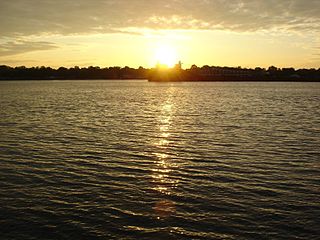
The Municipality of Trent Hills is a township municipality in Northumberland County in Central Ontario, Canada. It is on the Trent River and was created in 2001 through the amalgamation of the municipalities of Campbellford/Seymour, Percy Township and Hastings. Thereafter it was briefly known as Campbellford/Seymour, Percy, Hastings.
Paisley is an unincorporated community and village in the municipality of Arran–Elderslie, Bruce County in Southwestern Ontario, Canada. Paisley is defined by its position at the confluence of the Saugeen River and the Teeswater River, and at the junction of Bruce Roads 1, 11, and 3.

Fauquier-Strickland is a township municipality in Cochrane District in Northeastern Ontario, Canada. The three main communities in the township are Fauquier, Strickland, and Gregoires Mill. All are located along Ontario Highway 11 between the community of Departure Lake to the east and the municipality of Moonbeam to the west.

Val Rita-Harty is a township municipality in Cochrane District in Northeastern Ontario, Canada.

Chapple is a township municipality in Rainy River District in Northwestern Ontario, Canada.

Shabaqua Corners is a dispersed rural community and unincorporated area in geographic Dawson Road Lots Township in the Unorganized Part of Thunder Bay District in Northwestern Ontario, Canada. It is 56 kilometres (35 mi) west of Thunder Bay at the junction of Ontario Highway 17 and Ontario Highway 11; both highways at this point are part of the Trans-Canada Highway. There is an Ontario Provincial Police detachment in the community. The Oskondaga River flows through the community to its mouth at the Shebandowan River just to the south.

Wellington No. 97 is a rural municipality of 357 rural residents in the southeastern part of Saskatchewan, Canada. The RM was incorporated December 13, 1909. Its communities include Cedoux, Colfax, Tyvan and Rainton.

Hurkett is a dispersed rural community and unincorporated place in the Unorganized part of Thunder Bay District in northwestern Ontario, Canada. It is on Black Bay on the north shore of Lake Superior in geographic Stirling Township, and is on Ontario Highway 582, a short spur off Ontario Highway 17. Hurkett is a designated place served by a local services board, and has a population of 236.
Melgund is a geographic township and local services board in the Unorganized Part of Kenora District in northwestern Ontario, Canada. It has two unincorporated communities, Dyment and Borups Corners, and is counted as part of Kenora, Unorganized, Northern Ontario in Statistics Canada census data.
Girdwood is a railway point and unincorporated place in geographic Atkinson Township in the Unorganized North Part of Algoma District in northeastern Ontario, Canada. It lies on the Canadian Pacific Railway transcontinental main line between the settlements of Amyot on the line 13.5 kilometres (8.4 mi) to the west northwest and Ryerson on the line 4 kilometres (2 mi) to the northeast. Via Rail provides services to Girdwood railway station with the Sudbury – White River train once daily in each direction. Girdwood is adjacent to Tripoli Creek, a tributary of the Magpie River.
Shabaqua is a dispersed rural community and unincorporated area in geographic Laurie Township in the Unorganized Part of Thunder Bay District in Northwestern Ontario, Canada. It is on the right bank of the Shebandowan River, as well as on a Canadian National Railway main line, built originally as the Canadian Northern Railway transcontinental main line, between Mabella to the west and Glenwater to the southeast.

The Lomond River is a river in the Fort William First Nation and the Municipality of Neebing in Thunder Bay District in Northwestern Ontario, Canada. The river is part of the Great Lakes Basin, and flows from Loch Lomond through a small intermediate lake to Lake Superior.
Mulock is a dispersed rural community and unincorporated place in the municipality of West Grey, Grey County in Southwestern Ontario, Canada, named for William Mulock.
Stewart Township is a geographic township in the Unorganized North Part of Nipissing District in Northeastern Ontario, Canada. The Ontario Northland Railway, constructed in the early 20th century, runs from south to north through the township, and the dispersed rural community of Tomiko with two passing sidings is on the railway in the centre-east.
The Jocko River is a river in Nipissing District in Northeastern Ontario, Canada. It is in the Saint Lawrence River drainage basin, is a right tributary of the Ottawa River, and lies entirely within Jocko Rivers Provincial Park.
Osborne Township is a geographic township in the Unorganized North Part of Nipissing District in Northeastern Ontario, Canada. The Ontario Northland Railway, constructed in the early 20th century, runs from the middle south to the northwest of the township. The dispersed rural community of Jocko, without any passing sidings, and the railway point of Osborne, with one passing siding, are at the middle south and northwest of the township respectively.
Black Duck Creek is a stream in geographic Osborne Township in the Unorganized North Part of Nipissing District in Northeastern Ontario, Canada. It is in the Saint Lawrence River drainage basin, is a left tributary of the Jocko River, and lies entirely within Jocko Rivers Provincial Park.
Little Sucker Lake is a lake in geographic Osborne Township in the Unorganized North Part of Nipissing District in Northeastern Ontario, Canada, about 7 kilometres (4.3 mi) east of the railway point of Osborne on the Ontario Northland Railway. It is in the Saint Lawrence River drainage basin, and is the location of the mouth of Sucker Creek, the lake's only inflow, arriving at the northwest of the lake from the direction of Sucker Lake. The outflow from Little Sucker Lake flows out at the south as a left tributary of the Jocko River, which flows via Ottawa River to the Saint Lawrence River. The lake is entirely within Jocko Rivers Provincial Park.
Sucker Lake is a lake in geographic La Salle Township and geographic Osborne Township in the Unorganized North Part of Nipissing District in Northeastern Ontario, Canada, about 5.5 kilometres (3.4 mi) east of the railway point of Diver on the Ontario Northland Railway. It is in the Saint Lawrence River drainage basin and is the source of Sucker Creek.
Sucker Creek is a stream in geographic Osborne Township in the Unorganized North Part of Nipissing District in Northeastern Ontario, Canada. It is in the Saint Lawrence River drainage basin and is a tributary of Little Sucker Lake. Sucker Creek forms part of the border of Jocko Rivers Provincial Park.