Petrolia, Ontario

Last updated

Petrolia
Town of Petrolia
Petrolia ON 2.JPG
Nickname: 
Canada's Victorian Oil Town
Lambton locator map 2021.svg
Red pog.svg
Petrolia
Canada Southern Ontario location map 2.png
Red pog.svg
Petrolia
Coordinates: 42°53′N82°08.5′W / 42.883°N 82.1417°W / 42.883; -82.1417
CountryFlag of Canada (Pantone).svg  Canada
Province Flag of Ontario.svg  Ontario
County Lambton
Settled1866
Incorporated25 December 1866
Government
  MayorBrad Loosley
  Federal riding Sarnia—Lambton
  Prov. riding Sarnia—Lambton
Area
[1]
  Land12.68 km2 (4.90 sq mi)
Population
 (2016) [1]
  Total5,742
  Density452.8/km2 (1,173/sq mi)
Time zone UTC-5 (Eastern (EST))
  Summer (DST) UTC-4 (EDT)
Postal code
N0N 1R0
Area code(s) 519 and 226
Website town.petrolia.on.ca

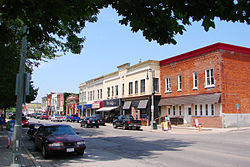
Petrolia is a town in southwestern Ontario, Canada. It is part of Lambton County and is surrounded by Enniskillen Township. It is billed as "Canada's Victorian Oil Town" and is often credited with starting the oil industry in North America, a claim shared with the nearby town of Oil Springs. [2]

Contents

Lambton Central Collegiate & Vocational Institute (LCCVI) is located in Petrolia.

History

Victoria Hall, housing Petrolia's municipal offices and a theatre, was built in 1889 Petrolia ON 3.JPG
Victoria Hall, housing Petrolia's municipal offices and a theatre, was built in 1889

In 1857, James Miller Williams of Hamilton began distilling some of the "tar" lying around Oil Springs (located a few kilometers south from Petrolia), after buying the property rights from Charles Nelson Tripp. In July or August 1858, he struck an oil deposit in Oil Springs while digging a shallow well, sparking the oil drilling industry. In 2008, the 150th anniversary of the discovery, Canada Post issued a stamp commemorating this first commercial oil well, featuring portraits of Charles Tripp and Williams. [3] However, these early wells resulted in a large amount of wastage from gushers, estimated at 5 million barrels (790,000 m3) of oil in 1862 alone. [4] [5]

Petrolia got its start in 1866 when a major gas well was found, resulting in an oil boom that caused many to abandon Oil Springs in favour of this new settlement. The place separated from Enniskillen Township and was incorporated as a town on 25 December of that same year. [6]

Oil production went through several boom periods in Petrolia; one was in 1898 and another in 1938. Some wells sunk in 1938 were initially producing 100 barrels per day (16 m3/d) at a price of $2 per barrel. This output, however, often lasted only a few weeks, falling to less than a barrel a day. [7]

Oil men from Petrolia travelled to the far reaches of the world (Gobi Desert, Arctic, Iran, Indonesia, United States, Australia, Russia, and over 80 other countries) teaching others how to find and extract crude oil. Those born and raised in Petrolia are referred to as "Hard Oilers", paying tribute to the toughness of their ancestors. Petrolia is also home to the Petrolia Discovery museum. Some oil fields in the area are still operational.

Media and entertainment

Petrolia is home to Victoria Hall, a National Historic Site of Canada. [8] Originally a fire hall, municipal office, police hall, jail and opera house, it was completed in 1889 for a total cost of $35,000. In January 1989, a fire caused extensive damage. It was subsequently restored, and re-opened in 1992. Currently it houses the town hall and Victoria Playhouse. [9]

Directly adjacent to Victoria Hall is Petrolia's Victoria Park, which hosts the annual 'PizzaFest' food festival as a collaboration between the town and their five local pizza restaurants. [10]

Until September 2013, The Petrolia Topic was the sole newspaper in the town of Petrolia. It is owned by Osprey Media. In September 2013, The Independent [11] of Petrolia & Central Lambton began publication.

The Oil Heritage District Community Centre was opened in Petrolia in 2006. It serves rural and town residents in central Lambton County.

Climate

Climate data for Petrolia (1981–2010)
MonthJanFebMarAprMayJunJulAugSepOctNovDecYear
Record high °C (°F)15.0
(59.0)
21.0
(69.8)
26.5
(79.7)
31.5
(88.7)
33.5
(92.3)
39.5
(103.1)
38.0
(100.4)
38.0
(100.4)
35.0
(95.0)
29.4
(84.9)
23.3
(73.9)
18.5
(65.3)
39.5
(103.1)
Mean daily maximum °C (°F)−1.3
(29.7)
0.6
(33.1)
5.8
(42.4)
13.0
(55.4)
19.8
(67.6)
25.2
(77.4)
27.7
(81.9)
26.4
(79.5)
22.6
(72.7)
15.3
(59.5)
8.0
(46.4)
1.6
(34.9)
13.7
(56.7)
Daily mean °C (°F)−5
(23)
−3.5
(25.7)
1.1
(34.0)
7.6
(45.7)
13.8
(56.8)
19.1
(66.4)
21.7
(71.1)
20.7
(69.3)
16.9
(62.4)
10.4
(50.7)
4.3
(39.7)
−1.8
(28.8)
8.8
(47.8)
Mean daily minimum °C (°F)−8.6
(16.5)
−7.5
(18.5)
−3.6
(25.5)
2.1
(35.8)
7.7
(45.9)
13.0
(55.4)
15.7
(60.3)
15.0
(59.0)
11.1
(52.0)
5.5
(41.9)
0.6
(33.1)
−5.1
(22.8)
3.8
(38.8)
Record low °C (°F)−30.0
(−22.0)
−27.0
(−16.6)
−25.0
(−13.0)
−13.0
(8.6)
−2.5
(27.5)
−1.7
(28.9)
5.6
(42.1)
2.0
(35.6)
−2.0
(28.4)
−7.2
(19.0)
−17.2
(1.0)
−22.0
(−7.6)
−30.0
(−22.0)
Average precipitation mm (inches)66.2
(2.61)
56.6
(2.23)
62.5
(2.46)
86.9
(3.42)
87.0
(3.43)
90.1
(3.55)
75.7
(2.98)
81.8
(3.22)
107.3
(4.22)
81.7
(3.22)
89.3
(3.52)
75.5
(2.97)
960.6
(37.82)
Average rainfall mm (inches)26.9
(1.06)
31.4
(1.24)
44.6
(1.76)
83.6
(3.29)
87.0
(3.43)
90.1
(3.55)
75.7
(2.98)
81.8
(3.22)
107.3
(4.22)
81.6
(3.21)
83.5
(3.29)
49.3
(1.94)
842.7
(33.18)
Average snowfall cm (inches)39.2
(15.4)
25.2
(9.9)
17.9
(7.0)
3.3
(1.3)
0.0
(0.0)
0.0
(0.0)
0.0
(0.0)
0.0
(0.0)
0.0
(0.0)
0.1
(0.0)
5.8
(2.3)
26.2
(10.3)
117.8
(46.4)
Average precipitation days (≥ 0.2 mm)16.412.713.715.513.011.811.311.512.013.515.315.0161.5
Average rainy days (≥ 0.2 mm)6.36.39.514.813.011.811.311.512.013.513.99.3133.2
Average snowy days (≥ 0.2 cm)11.37.96.01.60.00.00.00.00.00.082.17.836.8
Source: Environment Canada [12]

Demographics

Historical population
YearPop.±%
19914,598    
1996 4,908+6.7%
2001 4,849−1.2%
2006 5,222+7.7%
2011 5,528+5.9%
2016 5,742+3.9%
[13] [14] [1]

In the 2021 Census of Population conducted by Statistics Canada, Petrolia had a population of 6,013 living in 2,460 of its 2,524 total private dwellings, a change of 4.7% from its 2016 population of 5,742. With a land area of 12.46 km2 (4.81 sq mi), it had a population density of 482.6/km2 (1,249.9/sq mi) in 2021. [15]

Canada census – Petrolia community profile
2021 2016 2011
Population6,013 (+4.7% from 2016)5,742 (3.9% from 2011)5,528 (5.9% from 2006)
Land area12.46 km2 (4.81 sq mi)12.68 km2 (4.90 sq mi)12.68 km2 (4.90 sq mi)
Population density482.6/km2 (1,250/sq mi)452.8/km2 (1,173/sq mi)435.8/km2 (1,129/sq mi)
Median age42.8 (M: 40.4, F: 45.6)43.0 (M: 41.5, F: 44.7)
Private dwellings2,460 (total) 2,323 (total) 2,223 (total) 
Median household income$72,741
References: 2021 [16] 2016 [17] 2011 [14] earlier [18] [19]

Notable people

See also

Related Research Articles

<span class="mw-page-title-main">Sarnia</span> City in Ontario, Canada

Sarnia is a city in Lambton County, Ontario, Canada. It had a 2021 population of 72,047, and is the largest city on Lake Huron. Sarnia is located on the eastern bank of the junction between the Upper and Lower Great Lakes where Lake Huron flows into the St. Clair River in the Southwestern Ontario region, which forms the Canada–United States border, directly across from Port Huron, Michigan.

<span class="mw-page-title-main">Chatham-Kent</span> Municipality in Ontario, Canada

Chatham-Kent is a single-tier municipality in Southwestern Ontario, Canada. It is mostly rural, and its population centres are Chatham, Wallaceburg, Tilbury, Blenheim, Ridgetown, Wheatley and Dresden. The current Municipality of Chatham-Kent was created in 1998 by the amalgamation of Blenheim, Bothwell, Camden, the City of Chatham, the Township of Chatham, Dover, Dresden, Erie Beach, Erieau, Harwich, Highgate, Howard, Orford, Raleigh, Ridgetown, Duart, Thamesville, Tilbury East, Tilbury, Wallaceburg, Wheatley and Zone.

<span class="mw-page-title-main">Dawn-Euphemia</span> Township in Ontario, Canada

Dawn-Euphemia is a township in southwestern Ontario, Canada, in Lambton County. Residents primarily are employed by the agricultural industry, or by local industries such as Union Gas distribution centre, along with various smaller agricultural manufacturers or service providers. The township municipal office is located in Rutherford.

<span class="mw-page-title-main">Lambton County</span> County in Ontario, Canada

Lambton County is a county in Southwestern Ontario, Canada. It is bordered on the north by Lake Huron, which is drained by the St. Clair River, the county's western border and part of the Canada-United States border. To the south is Lake Saint Clair and Chatham-Kent. Lambton County's northeastern border follows the Ausable River and Parkhill Creek north until it reaches Lake Huron at the beach community of Grand Bend. The county seat is in the Town of Plympton-Wyoming.

<span class="mw-page-title-main">Imperial Oil</span> Canadian petroleum company majority-owned by American ExxonMobil

Imperial Oil Limited is a Canadian petroleum company that is headquartered in Calgary, Alberta, Canada. It is Canada's second-largest integrated oil company. It is majority-owned by American oil company ExxonMobil, with a 69.6% ownership stake in the company. It is a producer of crude oil, diluted bitumen, and natural gas. Imperial Oil is one of Canada's major petroleum refiners and petrochemical producers. It supplies Esso-brand service stations.

<span class="mw-page-title-main">Sarnia—Lambton (federal electoral district)</span> Federal electoral district in Ontario, Canada

Sarnia—Lambton is a federal electoral district in Ontario, Canada, that has been represented in the House of Commons of Canada since 1968. It is located in the area of the city of Sarnia, in the southwest corner of the province of Ontario.

<span class="mw-page-title-main">Lambton Shores</span> Municipality in Ontario, Canada

Lambton Shores is a municipality in Lambton County, Ontario, Canada, that is on the southern shores of Lake Huron.

<span class="mw-page-title-main">Plympton–Wyoming</span> Town in Ontario, Canada

Plympton–Wyoming is a town in the Canadian province of Ontario, located in Lambton County immediately east of Sarnia. It is the seat of the Lambton County Council.

<span class="mw-page-title-main">James Miller Williams</span> Canadian politician

James Miller Williams was a Canadian-American businessman and politician. Williams is best known for establishing the first commercially successful oil well in 1858 and igniting the first oil boom in North America. Williams is commonly viewed as the father of the petroleum industry in Canada.

<span class="mw-page-title-main">Oil Springs, Ontario</span> Village in Ontario, Canada

Oil Springs is a village in Lambton County, Ontario, Canada, located along Former Provincial Highway 21 south of Oil City. The village, an enclave within Enniskillen Township, is the site of North America's first commercial oil well. It is home to the Oil Museum of Canada.

<span class="mw-page-title-main">Lambton—Kent—Middlesex (provincial electoral district)</span> Provincial electoral district in Ontario, Canada

Lambton—Kent—Middlesex is a provincial electoral district in southwestern Ontario, Canada. It elects one member to the Legislative Assembly of Ontario.

<span class="mw-page-title-main">John Henry Fairbank</span> Canadian businessman and politician

John Henry Fairbank was variously a surveyor, oilman, inventor, banker, politician and fire chief in Lambton County, Ontario. Fairbank is best known for his invention of the jerker-line pumping system, which quickly spread across the world its introduction in the mid-1860s. Fairbank Oil, established by Fairbank in 1861, is the oldest continually operating petroleum company, and the company's property, known as the "First Commercial Oil Field", is included in the List of National Historic Sites of Canada in Ontario.

<span class="mw-page-title-main">Brooke-Alvinston</span> Municipality in Ontario, Canada

Brooke-Alvinston is a township municipality in the Canadian province of Ontario, located within Lambton County. It was formed on January 1, 2001, when the Township of Brooke was amalgamated with the Village of Alvinston.

<span class="mw-page-title-main">Enniskillen, Ontario</span> Township in Ontario, Canada

Enniskillen is a township in the Canadian province of Ontario, within Lambton County. It is located at the intersection of Highway 21 and Rokeby Line. The economy of the township is based on agriculture. It was named after Sir Galbraith Lowry Cole's father who was the Earl of Enniskillen, Northern Ireland.

Charles Nelson Tripp was a bitumen businessman in Ontario. Tripp is best known for his role in the formation of the International Mining and Manufacturing Company in 1854, the world's first incorporated oil company. Tripp and his brother Henry were among the first to exploit Enniskillen Township's bitumen deposits following Thomas Sterry Hunt and Alexander Murray's reports on the region and helped kickstart the first oil boom in Enniskillen Township.

<span class="mw-page-title-main">William Henry McGarvey</span>

William Henry McGarvey was a Canadian business magnate, entrepreneur and politician. McGarvey is best known for his exploits in Galicia, where he operated a highly successful petroleum company. McGarvey was one of the most successful "foreign drillers" of Petrolia, becoming a multimillionaire before the outbreak of the First World War destroyed his business.

<span class="mw-page-title-main">Jacob Lewis Englehart</span> Canadian business magnate, entrepreneur (1847–1921)

Jacob Lewis Englehart was a Canadian-American business magnate, entrepreneur and philanthropist. Englehart is best known for his role in the formation of Imperial Oil in 1880 to combat the growing influence of John D. Rockefeller's Standard Oil. Englehart was one of the most successful oil refiners in Canada during the 1800s and oversaw the completion of the Temiskaming and North Ontario Railway.

<span class="mw-page-title-main">Hugh Nixon Shaw</span> Irish-Canadian oil producer and businessman

Hugh Nixon Shaw is an Irish-Canadian oil producer and businessman. Shaw is best known for being misidentified as the discoverer of the Shaw well, Canada's first oil gusher, on January 16, 1862.

John Shaw was an American oil driller, businessman and photographer. Shaw is best known for striking Canada's first oil gusher at Oil Springs on January 16, 1862. Shaw's oil gusher marked the beginning of the first oil boom in Enniskillen Township, as speculators rushed to Oil Springs seeking similar fortunes.

<span class="mw-page-title-main">International Drillers</span>

The International Drillers is the name given to the more than 500 drillers from Lambton County who worked in oil fields across the world between December 1873 to the mid-1940s. Many of the International Drillers grew up learning the oil business in Enniskillen County and provided the skilled labour, expertise and technology necessary for the development of the global petroleum industry.

References

  1. 1 2 3 "Petrolia census profile". 2016 Census of Population . Statistics Canada. Retrieved 18 March 2017.
  2. "Oil Springs". Oil Museum of Canada. Archived from the original on 7 August 2008.
  3. "Industries: Oil and Gas". Canada Post Corporation. Archived from the original on 9 October 2012.
  4. Gulless, Micky; Earle Gray; Robert Bott. "Petroleum History Society - Canadian Beginnings". The Petroleum History Society. Retrieved 7 February 2006.
  5. Gray, Earle (2008). "Gesner and Williams: two Canadians who launched the world's petroleum industry" (PDF). Retrieved 31 December 2008.[ dead link ]
  6. "History of Oil Springs". The Village of Oil Springs. Archived from the original on 6 July 2011. Retrieved 23 February 2011.
  7. Trestain, W.G. (15 July 1939). "unknown". The London Free Press.{{cite news}}: Cite uses generic title (help)
  8. Victoria Hall / Petrolia Town Hall National Historic Site of Canada . Canadian Register of Historic Places .
  9. "About the Victoria Playhouse Petrolia". Archived from the original on 3 August 2007. Retrieved 8 August 2007.
  10. "9th Annual Pizzafest". visitpetrolia.ca. Retrieved 7 December 2022.
  11. "The Oil Heritage District Community Centre Association celebrated for excellence" (PDF) (Press release). Foundation for Rural Living. 12 April 2006. Archived from the original (PDF) on 17 July 2011. Retrieved 8 December 2008.
  12. "Petrolia Town, Ontario". Canadian Climate Normals 1981–2010 (in English and French). Environment Canada. Archived from the original on 23 July 2019. Retrieved 22 July 2019.
  13. Statistics Canada: 1996, 2001, 2006 census
  14. 1 2 "2011 Community Profiles". 2011 Canadian Census . Statistics Canada. 21 March 2019. Retrieved 9 February 2012.
  15. "Population and dwelling counts: Canada, provinces and territories, census divisions and census subdivisions (municipalities), Ontario". Statistics Canada. 9 February 2022. Retrieved 30 March 2022.
  16. "2021 Community Profiles". 2021 Canadian Census . Statistics Canada. 4 February 2022. Retrieved 27 April 2022.
  17. "2016 Community Profiles". 2016 Canadian Census . Statistics Canada. 12 August 2021. Retrieved 17 June 2019.
  18. "2006 Community Profiles". 2006 Canadian Census . Statistics Canada. 20 August 2019.
  19. "2001 Community Profiles". 2001 Canadian Census . Statistics Canada. 18 July 2021.

Further reading