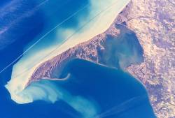
Long Point, Ontario

Last updated

Long Point, Ontario
Unincorporated hamlet in Norfolk County
LongPointLakeErieOntario23.jpg
Long Point Peninsula with bright sediment plumes. (The top of the image points southwest, rather than north.) Source: NASA
Canada Ontario location map 2.svg
Red pog.svg
Long Point, Ontario
Location of Long Point in Ontario
Coordinates: 42°32′51″N80°3′33″W / 42.54750°N 80.05917°W / 42.54750; -80.05917
CountryCanada
Province Ontario
Amalgamated into Norfolk County2001 (Single-tier municipality)
Government
  MayorKristal Chopp
  Governing BodyThe Council of The Corporation of Norfolk County
   MPs Diane Finley (Con)
   MPPs Toby Barrett (PC)
Elevation
210 m (690 ft)
Time zone UTC-5 (EST)
  Summer (DST) UTC-4 (EDT)
Forward sortation area
Area code(s) 519 and 226
Website www.norfolkcounty.ca
Official nameLong Point
Designated24 May 1982
Reference no.237 [1]

Long Point is a sand spit and medium-sized hamlet on the north shore of Lake Erie, part of Norfolk County in the province of Ontario, Canada.

Contents

It is about 40 kilometres (25 mi) long and is about 1 kilometre (0.62 mi) across at its widest point. Lake Erie lies to the south of Long Point, and Long Point Bay lies on the north side. The bay is subdivided into the Inner Bay and Outer Bay by a line that runs between Turkey Point to the north and Pottahawk Point to the south. Some of the towns along the bay's north shore include Port Rowan, Turkey Point and Port Dover. Long Point is north of and across the lake from Presque Isle and Erie, Pennsylvania.

History

Settlers from Europe began arriving in this area in 1790. After the American Revolution, many Loyalists began to settle here but after 1796, land was given to anyone who was capable of developing it. The first lighthouse was built in 1830.

The recently renovated Old Cut Lighthouse. Lighthouse on Long Point, Norfolk County.jpg
The recently renovated Old Cut Lighthouse.

In the 19th century, a powerful storm cut an opening through the middle of Long Point. A lighthouse was built alongside the channel, which was the first of several on the point. The opening became known as "The Old Cut". The cut has since closed along the lakeshore, but boaters continue to use the northern portion to reach the bay, homes and cottages.

During the mid-19th century some of local residents saw an opportunity to make easy money by "blackbirding." Blackbirders erected fake lighthouses during times of low visibility. Ships trying to enter the old cut would run aground. When the crew abandoned ship the blackbirders would loot the ship of cargo and other valuables. With law enforcement based in London, Ontario, these blackbirders would store their loot on the many hiding spots that Long Point offered.

Abigail Becker on several occasions in the 19th century waded into stormy waters to save crew members of boats that had run aground. Long Point has caused many shipwrecks, with many of the wrecks located right off the tip of the point. More than 400 ships have sunk in an area called "The Lake Erie Quadrangle".

Sport hunting was important after the Long Point Company purchased the Point in 1866 to facilitate this pursuit. Long Point Provincial Park was created in May 1921; by 1929, it was connected to the mainland by a new causeway. [2]

Economy and recreation

The year-round population of Long Point is about 450 people, but the population increases in summer months when cottagers and campers visit. [3] Long Point is popular destination for boating, swimming, fishing, waterfowl-hunting and canoeing, attracting between 100,000 [3] and 300,000 visitors each year. [4] A large portion of Long Point is owned by the Long Point Company, a private organization that does not allow the public onto its property. [3] Because of this, most homes, cottages and business are within the first few kilometres of the causeway that carries the road between Long Point and the mainland. [3] Long Point Provincial Park, a popular destination for day visitors and campers, is located on the peninsula

Natural environment

Long Point is an example of sand dune and sand-spit formation in the Great Lakes region. It is the largest erosion deposit formation in the Great Lakes, created by water-borne sediments swept eastward and deposited in part along an underwater glacial moraine. Habitats on and surrounding Long Point include woodlands, sand dunes and bluffs, marshes, ponds, meadows, beaches and lakeshore. The complex is the largest biophysical formation of its kind in the Laurentian Great Lakes of North America. [4] North of the peninsula lie several islands, [5] including Ryerson's, Second, and Snow.

In 1982, the Long Point National Wildlife Area was recognized as a wetland of international significance under the Ramsar Convention. In 1986, Long Point Biosphere Reserve was designated as a World Biosphere Reserve by UNESCO and as a globally significant Important Bird Area by Bird Life International. [4] The Ontario Ministry of Natural Resources classifies Long Point as a Macrosite, an area that contains numerous ecological or geological significant zones, [6] such as Areas of Natural and Scientific Interest.

Inner Long Point Bay covers approximately 78 km2 (30 sq mi) between the spit and Lake Erie's north shore. The Inner Bay is a diverse sport fishery and continentally important staging area for migratory waterfowl. Immediately adjacent to the coastal reserve is a distinctive terrestrial area of temperate 'Carolinian' broadleaf forests, conifer plantations, oak savannas and diverse agro-ecosystems. [4]

Wildlife

The region is an important location for bird migration in spring and autumn. It is a major staging area for a variety of waterfowl. "Long Point itself is one of the most important wetland complexes for migrating waterfowl in southern Canada, and is reported to receive the highest waterfowl use (based on numbers of waterfowl days during spring and fall migration) of any area on the Great Lakes (approximately 4 million days per year). Up to 30,000 Tundra Swans pass through the area in spring, and up to 8% of the world's Canvasbacks congregate in the area on any one day during spring and fall," according to a report by the Long Point World Biosphere Reserve. [7]

In 1960, the Long Point Bird Observatory was established to monitor migrant birds on the point. It is North America's oldest bird observatory. As a result of a growing national focus towards saving the birds, the organization was renamed Bird Studies Canada in 1998. Its national headquarters overlooks Long Point Inner Bay on the western limits of Port Rowan, adjacent to base of the peninsula.

The Long Point Biosphere Reserve and surrounding area is home to 1384 species of plant, 370 species of birds, 102 species of fish, 46 species of mammals, 34 species of amphibians and reptiles, and 91 species of butterflies. These include Species at Risk such as American ginseng (Panax quinquefollus), American badger (Taxidea taxus), Acadian flycatcher (Empidonax virescens) and channel darter (Percina copelandi). [4]

Climate

According to the Atlas of Canada, Long point has a cool summer humid continental climate with no dry season (Köppen climate classification Dfb). [3] The climate of Long Point is influenced by Lake Erie, causing spring and summer temperatures to be cooler, and autumn and winter temperatures to be warmer than the adjacent mainland. [8] Winters are relatively cool, with a mean temperature of 1 °C (33.8 °F) while summers are warm, averaging 22 °C (71.6 °F). [3] [8] Long Point averages 860 mm (34 in) of precipitation per year. [8] It is estimated that Long Point averages 2,000 hours of bright sunshine per year or 45% of possible sunshine. [3]

Climate data for Long Point, Ontario (1981–2010 averages)
MonthJanFebMarAprMayJunJulAugSepOctNovDecYear
Average high °C (°F)0.5
(32.9)
0.0
(32.0)
3.6
(38.5)
9.5
(49.1)
15.4
(59.7)
20.3
(68.5)
23.5
(74.3)
23.5
(74.3)
20.1
(68.2)
14.2
(57.6)
8.5
(47.3)
2.6
(36.7)
11.8
(53.2)
Daily mean °C (°F)−2.8
(27.0)
−3.1
(26.4)
0.8
(33.4)
6.5
(43.7)
12.5
(54.5)
18.1
(64.6)
21.5
(70.7)
21.6
(70.9)
18.3
(64.9)
12.1
(53.8)
6.3
(43.3)
−0.2
(31.6)
9.3
(48.7)
Average low °C (°F)−4.7
(23.5)
−5.5
(22.1)
−2.0
(28.4)
3.2
(37.8)
9.2
(48.6)
15.6
(60.1)
19.4
(66.9)
19.6
(67.3)
15.6
(60.1)
9.6
(49.3)
3.9
(39.0)
−1.9
(28.6)
6.8
(44.2)
Source: Infoclimat.fr [9]

See also

Related Research Articles

<span class="mw-page-title-main">Point Pelee National Park</span> National park of Canada in Ontario

Point Pelee National Park is a national park in Essex County in southwestern Ontario, Canada where it extends into Lake Erie. The word pelée is French for 'bald'. Point Pelee consists of a peninsula of land, mainly of marsh and woodland habitats, that tapers to a sharp point as it extends into Lake Erie. Middle Island, also part of Point Pelee National Park, was acquired in 2000 and is just north of the Canada–United States border in Lake Erie. Point Pelee is the southernmost point of mainland Canada, and is located on a foundation of glacial sand, silt and gravel that bites into Lake Erie. This spit of land is slightly more than seven kilometres long by 4.5 kilometres (2.8 mi) wide at its northern base. Established in 1918, Point Pelee was the first national park in Canada to be established for conservation. It was designated as a Ramsar site on 27 May 1987.

<span class="mw-page-title-main">Lake Saint Pierre</span>

Lake Saint Pierre is a lake in Quebec, Canada, a widening of the Saint Lawrence River between Sorel-Tracy and Trois-Rivières. It is located downstream, and northeast, of Montreal; and upstream, and southwest, of Quebec City. The end of the lake delimits the beginning of the estuary of Saint Lawrence.

UNESCO Biosphere Reserves are environment-protected scientific-research institutions of international status that are created with the intent for conservation in a natural state the most typical natural complexes of biosphere, conducting background ecological monitoring, studying of the surrounding natural environment, its changes under the activity of anthropogenic factors.

<span class="mw-page-title-main">Transboundary protected area</span>

A transboundary protected area (TBPA) is an ecological protected area that spans boundaries of more than one country or sub-national entity. Such areas are also known as transfrontier conservation areas (TFCAs) or peace parks.

<span class="mw-page-title-main">Presqu'ile Provincial Park</span> Ontario park

Presqu'ile Provincial Park is a park in southeastern Northumberland County on the north shore of Lake Ontario near the town of Brighton in Ontario, Canada. The park occupies an area of 9.37 km2 (3.62 sq mi). The name of the park is the French word for peninsula, or literally "almost island", and was believed to be named by Samuel De Champlain on his second expedition. The peninsula was formed when a limestone island was connected to the mainland by a sand spit; this kind of formation is referred to as a tombolo.

<span class="mw-page-title-main">Rondeau Provincial Park</span> Provincial park in Ontario

Rondeau Provincial Park is the second oldest provincial park in Ontario, Canada, having been established with an order in council on 8 September 1894. The park is located in Southwestern Ontario, on an 8 km long crescentic sand spit extending into Lake Erie. Rondeau is home to the largest area of Carolinian forest in Canada, a long sand beach, a large marsh, approximately half of Rondeau Bay, campgrounds and a cottage community. The name of the park comes from the French words "ronde eau" or "round water" which describes the shape of the harbour sheltered by the peninsula.

<span class="mw-page-title-main">Peace–Athabasca Delta</span> River delta in Northeast Alberta

The Peace–Athabasca Delta, located in northeast Alberta, is the largest freshwater inland river delta in North America. It is located partially within the southeast corner of Wood Buffalo National Park, Canada's largest national park, and also spreads into the Regional Municipality of Wood Buffalo, west and south of the historical community of Fort Chipewyan. The delta encompasses approximately 321,200 ha, formed where the Peace and Athabasca rivers converge on the Slave River and Lake Athabasca. The delta region is designated a wetland of international importance and a UNESCO World Heritage Site. The region is large enough that it is considered one of twenty distinct natural subregions of Alberta by the provincial government's Natural Regions Committee.

Long Point may refer to:

<span class="mw-page-title-main">Colorado River Delta</span> River delta in Baja California and Sonora, Mexico

The Colorado River Delta is the region where the Colorado River flows into the Gulf of California in eastern Mexicali Municipality in the north of the state of Baja California in northwesternmost Mexico. The delta is part of a larger geologic region called the Salton Trough. Historically, the interaction of the river's flow and the ocean's tide created a dynamic environment, supporting freshwater, brackish, and saltwater species. Within the delta region, the river split into multiple braided channels and formed a complex estuary and terrestrial ecosystems. The use of water upstream and the accompanying reduction of freshwater flow has resulted in the loss of most of the wetlands of the area, as well as drastic changes to the aquatic ecosystems. However, a scheme is currently in place which aims to rejuvenate the wetlands by releasing a pulse of water down the river delta.

<span class="mw-page-title-main">Long Point Provincial Park</span> Provincial park near Port Rowan, Ontario

Long Point Provincial Park is a provincial park on the northwest shore of Lake Erie near Port Rowan, Ontario, Canada. The park is part of a sandy spit of land called Long Point that juts out into the lake. It covers part of the area of Long Point Biosphere Reserve, which was designated a UNESCO Biosphere Reserve because of its biological significance.

<span class="mw-page-title-main">Miankaleh peninsula</span> Peninsula in Māzandarān Province, Iran

Miyānkāle peninsula is a long, narrow peninsula in Behshahr County of Māzandarān Province in the north of Iran situated in the extreme south-eastern part of the Caspian Sea. The elongate peninsula is 48 kilometres long, and between 1.3 and 3.2 kilometres wide.

<span class="mw-page-title-main">Long Point Biosphere Reserve</span> Biosphere Reserve in Ontario, Canada

The Long Point Biosphere Reserve is located in southern Canada on the shores of Lake Erie in Norfolk County. The area encompasses a rich mosaic of ecological systems associated with erosion deposit sand spit formations around the Laurentian Great Lakes, as well as some of the largest remaining forest tracts in "Carolinian Canada". The variety of habitats supports a rich flora and fauna, including a waterfowl staging area and a migration stopover area for land birds of continental importance. Long Point Biosphere Reserve has been recognized as a Ramsar site and as a globally significant Important Bird Area by Bird Life International. Established in 1960, the bird observatory is the oldest, continuously operated, in North America.

<span class="mw-page-title-main">Westmeath Provincial Park</span> Provincial Park in Westmeath, Ontario

Westmeath Provincial Park is a provincial park on the Ottawa River in Renfrew County, Ontario, Canada. Located on the section of the river known as Bellows Bay, it features a long sandy beach and an active sandspit. It is one of the most pristine sand dune and wetland complexes along the southern Ottawa River.

<span class="mw-page-title-main">Quill Lakes</span> Protected lakes in Saskatchewan, Canada

The Quill Lakes is a wetland complex in Saskatchewan, Canada that encompasses the endorheic basin of three distinct lake wetlands: Big Quill Lake, Middle Quill Lake, and Little Quill Lake. On May 27, 1987, it was designated a wetland of international importance via the Ramsar Convention. It was the first Canadian site in the North American Waterfowl Management Plan, is a site in the International Biological Programme and Saskatchewan Heritage Marsh Program, and was designated a Western Hemisphere Shorebird Reserve Network site of International significance in May, 1994. The site is an important staging and breeding area for spring and fall migration of shorebirds. The site qualifies as an Important Bird Area (IBA) of Canada for its globally and nationally significant migratory and breeding populations of more than a dozen species of birds. The IBA is designated as Quill Lakes .

<span class="mw-page-title-main">Mary's Point</span> Wetland in Albert County, New Brunswick, Canada

Mary's Point is a 12 square kilometres (4.6 sq mi) wetland in Albert County, New Brunswick, Canada. It is at the head of the Bay of Fundy, just outside the small community of Harvey and approximately 40 km (25 mi) south of Moncton. Designated a Ramsar wetland of international importance on May 24, 1982, it is also part of the Fundy biosphere reserve established in 2007, which also contains the Shepody Bay wetland. It was also the first Canadian site in the Western Hemisphere Shorebird Reserve, as part of the Bay of Fundy Hemisphere Shorebird Reserve. It is within the Shepody Bay National Wildlife Area, which is administered by the Canadian Wildlife Service.

<span class="mw-page-title-main">Wildlife of Ukraine</span>

The wildlife of Ukraine consists of its diverse fauna, flora and funga. The reported fauna consists of 45,000 species when including the areas of the Black Sea and the Sea of Azov. Ukraine's protected environments consist of 33 Ramsar sites covering an area of 7,446.51 square kilometres (2,875.11 sq mi). Biosphere nature reserves and three national parks are all part of the GEF projects portfolio of conservation of biodiversity in the Danube Delta. Their vegetation pattern is mixed forest area, forest-steppe area, steppe area, Ukrainian Carpathian Mountains and Crimean Mountains. Some of the protected areas that were reserves or parks are subsumed under the biosphere reserves.

<span class="mw-page-title-main">Alakol Biosphere Reserve</span> Biospehere reserve in the country of Kazakhstan

The Alakol Biosphere Reserve is a UNESCO Biosphere Reserve located in Kazakhstan, within the desert zone of Eurasia in the central part of the Alakol inter-mountain depression. The 193,089 hectares (745.52 sq mi) reserve lies on the Central Asian–Indian bird migration route. The wetlands of the reserve are of global significance as a habitat and as a nesting site for water birds.

Big Creek is a watercourse in Norfolk County, Ontario. It is approximately 60 kilometres (37 mi) long. It empties into Lake Erie, at Port Rowan, at Long Point. Its watershed covers 730 square kilometres (280 sq mi), alternately 750 square kilometres (290 sq mi).

<span class="mw-page-title-main">Long Point National Wildlife Area</span> National Wildlife Protected area in Ontario, Canada.

The Long Point National Wildlife Area is a Protected area of Canada and one of ten National Wildlife Areas in Ontario. It is the core area of the Long Point Biosphere Reserve, created in 1986, and has been recognized as a Ramsar site since 1982.

Sturgeon Bay Provincial Park is a provincial park on the western shore of Lake Winnipeg in Manitoba, Canada. The park is considered to be a Class Ib protected area under the IUCN protected area management categories. It is 144.9 km2 (55.9 sq mi) in size.

References

  1. "Long Point". Ramsar Sites Information Service. Retrieved 25 April 2018.
  2. "Cultural Heritage Landscape and Built Heritage Study" (PDF). Norfolk County. 2007. Archived from the original (PDF) on 2012-02-23. Retrieved 2018-09-23.
  3. 1 2 3 4 5 6 7 "Three Wildlife Culverts (Ecopassages) on the Long Point Causeway between Lakeshore Rd and Erie Blvd, Long Point, Norfolk County Environmental Assessment Report" (PDF). The Corporation of Norfolk County. Archived from the original (PDF) on 5 January 2016. Retrieved 8 November 2015.
  4. 1 2 3 4 5 "Long Point | United Nations Educational, Scientific and Cultural Organization". www.unesco.org (Used under CC-BY-SA IGO 3.0, per WikiProject UNESCO's Create Biosphere Reserve Articles). Retrieved 2016-05-21.
  5. "How Many Islands Are There in Lake Erie?" (PDF).
  6. "Natural Areas Report: LONG POINT BIOSPHERE RESERVE". Government of Ontario Ministry of Natural Resources. Archived from the original on 2006-12-18. Retrieved 2007-07-30.
  7. "Waterfowl and Wetlands of Long Point Bay and Old Norfolk County: 8.0 Waterfowl Distribution and Abundance on Long Point Bay". longpointbiosphere.com. Long Point World Biosphere Reserve Foundation. Retrieved 2016-05-21.
  8. 1 2 3 "Canada 2: Long Point National Wildlife Area, Ontario: Information Sheet on Ramsar Wetlands" (PDF). Retrieved 8 November 2015.
  9. "Normes et records pour la période 1981–2010 à Station météorologique de Long Point" (in French). Infoclimat. Archived from the original on 24 June 2019. Retrieved 23 June 2019.

Sources