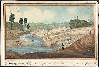
The Cataraqui River forms the lower portion of the Rideau Canal and drains into Lake Ontario at Kingston, Ontario. The name is taken from the original name for Kingston, Ontario; its exact meaning, however, is undetermined. Early maps showed several name variations including the Great Cataraqui River and Grand River Cataraquay. The river was once called Riviere de Frontenac, or Frontenac River. The alternate spelling "Cadaraqui" also appears in some historic texts.

The East Bay Regional Park District (EBRPD) is a special district operating in Alameda County and Contra Costa County, California, within the East Bay area of the San Francisco Bay Area. It maintains and operates a system of regional parks which is the largest urban regional park district in the United States. The administrative office is located in Oakland.

The Little Cataraqui Creek is a watercourse, much of which is a semi-urban wetland, that empties into Lake Ontario within the municipality of Kingston, Ontario, Canada. Further inland, just north of Highway 401, the creek has been dammed to form a reservoir that is part of the Little Cataraqui Creek Conservation Area.
Collins Bay is a bay and natural harbour, as well as a community, within the western part of the municipality of Kingston, Ontario, Canada. Collins Bay was at one time a small village, but it became absorbed by the city of Kingston. Now Collins Bay consists mostly of residential subdivisions, a large conservation area, Kingston Norman Rogers Airport, and areas of agricultural land. The Collins Bay marina is situated on the bay itself. To the east is a large federal penitentiary, Collins Bay Institution.

Cataraqui Cemetery is a non-denominational cemetery located in Kingston, Ontario, Canada. Founded in 1850, it predates Canadian Confederation, and continues as an active burial ground. The cemetery is 91 acres in a rural setting with rolling wooded terrain, ponds and watercourses. More than 46,000 individuals are interred within the grounds, and it is the final resting place of many prominent Canadians, including the burial site of Canada's first prime minister, John A. Macdonald. The Macdonald family gravesite, and the cemetery itself, are both designated as National Historic Sites of Canada.
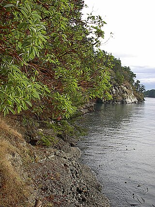
Collinson Point Provincial Park is a provincial park on Galiano Island, British Columbia, Canada. It is located between Mount Galiano and the western approaches to Active Pass. The area is 24 hectares, with c. 500 metres of waterfront.
The Claireville Conservation Area is a suburban conservation area located on the border of Peel Region and Toronto in Ontario, Canada. The major part of the area is located in Brampton. The park is a 343 hectare parcel of conservation land located on the west branch of the Humber River. It is one of the largest tracts of land owned by the Toronto and Region Conservation Authority (TRCA). Claireville contains significant natural and cultural heritage features, and has recreation, tourism, and educational facilities and programs.
The Ventana Wilderness of Los Padres National Forest is a federally designated wilderness area located in the Santa Lucia Range along the Central Coast of California. This wilderness was established in 1969 when the Ventana Wilderness Act redesignated the 55,800-acre (22,600 ha) Ventana Primitive Area as the Ventana Wilderness and added land, totalling 98,000 acres. In 1978, the Endangered American Wilderness Act added 61,000 acres, increasing the total wilderness area to about 159,000 acres. The California Wilderness Act of 1984 added about 2,750 acres. The Los Padres Condor Range and River Protection Act of 1992 created the approximately 14,500-acre (5,900 ha) Silver Peak Wilderness and added about 38,800 acres to the Ventana Wilderness in addition to designating the Big Sur River as a Wild and Scenic River. The Big Sur Wilderness and Conservation Act of 2002 expanded the wilderness for the fifth time, adding nearly 35,000 acres (14,000 ha), increasing the total acreage of the wilderness to its present size of 240,026 acres (97,135 ha).

Harrowsmith is a community in South Frontenac, Ontario, Canada. Located north of Kingston, it was once noted for the cheddar cheese produced by the Harrowsmith Cheese Factory. As a farming village in an area resettled by many back-to-the-land emigrants from urban areas in the 1960s–1980s, the village gave its name to the country living magazine Harrowsmith.
Little Cataraqui Creek Conservation Area is a 394-hectare (970-acre) conservation area located north of the city of Kingston, Ontario, Canada, and is managed by the Cataraqui Region Conservation Authority.
The Kingston Centre was an indoor mall built in Kingston, Ontario in 1955 and demolished in 2004. The Kingston Centre name now belongs to a 223,327 sq ft (20,747.8 m2). campus-style open-air shopping centre on the same site, which replaced the now-demolished indoor mall.
Cataraqui Golf and Country Club is a private golf and curling club located in Kingston, Ontario, Canada. It was founded in 1917.

Black Pond Wildlife Management Area is a 526-acre (213 ha) New York State Wildlife Management Area (WMA) that lies on the eastern shore of Lake Ontario, and at the northern limit of an unusual region of sandy barrier beaches and lagoons. Much of the barrier beach in Black Pond WMA has forested sand dunes that are about 60 feet (18 m) high; these are the highest sand dunes in the northeast United States excepting Cape Cod. Immediately north of the WMA is the 360-acre (150 ha) El Dorado Beach Preserve, which is a bird refuge owned by The Nature Conservancy. North of the outlet from Black Pond to Lake Ontario, the shoreline is a weathered, flat bedrock shelf that is "calcareous" instead of sandy.

Portsmouth Village is a formerly incorporated village in Ontario which was annexed to become a neighbourhood of Kingston, Ontario, Canada in 1952.
The Mac Johnson Wildlife Area is a 532-hectare (1,310-acre) wildlife area north of Brockville, Ontario, Canada, that includes wetland, fields, and forest land, as well as a reservoir that maintains water levels for the Buells Creek watershed flowing through the Township of Elizabethtown-Kitley and the City of Brockville. The wildlife area is managed by the Cataraqui Region Conservation Authority (CRCA). The area is open to visitors and offers 11km of walking paths through woodland, wetland and open fields.
Johan Jost Herkimer was a Loyalist born in 1732, the second of five sons of Johan Jost Herkimer and Anna Catherine Petri of German Flatts, Province of New York. He was the younger brother of the American Patriot General Nicholas Herkimer.
Point Frederick is a 41-hectare (101-acre) peninsula in Kingston, Ontario, Canada. The peninsula is located at the south end of the Rideau Canal where Lake Ontario empties into the St. Lawrence River. Point Frederick is bounded by the Cataraqui River to the west, the St. Lawrence River to the south, and Navy Bay to the east. The peninsula is occupied by the Royal Military College of Canada (RMC). Several of the buildings located on Point Frederick and the site of the old naval dockyard are national historic sites. Fort Frederick, at the south end of the peninsula, is a feature of the Kingston Fortifications National Historic Site of Canada.

Gould Lake Conservation Area is a rural conservation area located in the Canadian Shield northwest of the community of Sydenham in the Township of South Frontenac, Frontenac County, in eastern Ontario, Canada. The area was created to manage water resources, preserve wildlife habitat, and provide recreational and educational opportunities, and is managed by the Cataraqui Region Conservation Authority. The conservation area contains much of Gould Lake.

The Cataraqui Trail is a 104-kilometre (65 mi) multi-use linear recreational rail trail in Eastern Ontario, Canada. The route passes by farmland, woods, lakes, and wetlands. The trail begins southwest of Smiths Falls, at a parking lot south of Ontario Highway 15 designated as kilometre zero.
The Cataraqui Region Conservation Authority is one of 36 conservation authorities in the Canadian province of Ontario. It is headquartered in Kingston, Ontario The authority was established by an Order in Council in December 1964 via the Conservation Authorities Act, and is a member authority of Conservation Ontario.
 Woodland trail near the shore of Lake Ontario
 Trail through an open field near the airport
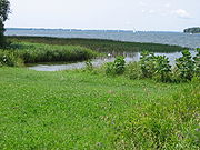 Marshy shoreline on Collins Bay
 Deer crossing the broad trail
 Main parking lot


