Related Research Articles

South San Francisco is a city in San Mateo County, California, United States, located on the San Francisco Peninsula in the San Francisco Bay Area. The city is colloquially known as "South City". The population was 63,632 at the 2010 census.

Kingston is a city in Ontario, Canada. It is located on the eastern end of Lake Ontario, at the beginning of the St. Lawrence River and at the mouth of the Cataraqui River. The city is midway between Toronto, Ontario, and Montreal, Quebec. Kingston is also located nearby the Thousand Islands tourist region to the east and the Prince Edward County tourist region to the west. Kingston is nicknamed the "Limestone City" because of the many heritage buildings constructed using local limestone.

Pickering is a city located in Southern Ontario, Canada, immediately east of Toronto in Durham Region. For centuries, it fell under the stewardship of the Iroquoian-speaking Wyandotte.

Land reclamation, usually known as reclamation, and also known as land fill, is the process of creating new land from oceans, seas, riverbeds or lake beds. The land reclaimed is known as reclamation ground or land fill.

The Toronto waterfront is the lakeshore of Lake Ontario in the City of Toronto, Ontario in Canada. It spans 46 kilometres between the mouth of Etobicoke Creek in the west, and the Rouge River in the East.
Guildwood, also known as Guildwood Village, is a residential neighbourhood in Scarborough, Toronto, Ontario, Canada. It is located along the Scarborough Bluffs, south of Kingston Road, from Grey Abbey Trail in the east.

The Quebec City–Windsor Corridor is the most densely populated and heavily industrialized region of Canada. As its name suggests, the region extends between Quebec City in the northeast and Windsor, Ontario, in the southwest, spanning 1,150 kilometres (710 mi). With more than 18 million people, it contains about half of the country's population, three of Canada's five largest metropolitan areas and eight of Canada's twelve large metropolitan areas, all based on the 2016 census. Its relative importance to Canada's economic and political infrastructure renders it akin to the Northeast megalopolis in the United States. The name was first popularized by Via Rail, which runs frequent passenger rail service in the region in its service area known as "The Corridor".

The Kingston railway station is an inter-city passenger rail station in Cataraqui, Kingston, Ontario, Canada. It is served by Via Rail trains running from Toronto to Ottawa or Montreal, along the Corridor route. It is located on John Counter Boulevard, northeast of Princess Street and north-west of downtown Kingston.

Saint Andrew is a parish, situated in the southeast of Jamaica in the county of Surrey. It lies north, west and east of Kingston, and stretches into the Blue Mountains. In the 2011 census, it had 573,369, the highest population of any of the parishes in Jamaica. George William Gordon, one of Jamaica's seven National Heroes, was born in this parish.

RCAF Station Kingston was a World War II air training station built in 1940 at Collins Bay near Kingston, Ontario, Canada. The station was originally built by the Royal Canadian Air Force (RCAF) for use by the Royal Air Force (RAF). Like other RAF schools in Canada, it was subject to RCAF administrative and operational control.

The District of North Saanich is located on the Saanich Peninsula of British Columbia, approximately 25 km (16 mi) north of Victoria on southern Vancouver Island. It is one of the 13 Greater Victoria municipalities. The District is surrounded on three sides by 20 km (12 mi) of ocean shoreline, and consists of rural/residential areas, a large agricultural base and is home to the Victoria International Airport and the Swartz Bay Ferry Terminal.
Oklahoma City is near the geographic center of the United States and is an integral point on the U.S. Interstate Network. The city is served by numerous roads and highways, toll roads, three major airports, a train station, a bus station, and a transit system.

Claireville is a neighbourhood and former hamlet in the city of Toronto, Ontario, Canada. It is located in the northwest corner of Toronto, in the former city of Etobicoke. Today Claireville is almost wholly industrial/commercial.

The Oklahoma City metropolitan area is an urban region in Central Oklahoma. It is the largest metropolitan area in the state of Oklahoma and contains the state capital and principal city, Oklahoma City. It is often known as the Oklahoma City Metro, Oklahoma City Metroplex, or Greater Oklahoma City in addition to the nicknames Oklahoma City itself is known for, such as OKC or 'the 405'.

The Township of Verulam was a rural municipality within the former Victoria County, now the city of Kawartha Lakes. It was bounded on the north by the geographic township of Somerville, the south by the geographic township of Emily, the west by the geographic township of Fenelon, and the east by the County of Peterborough. For the purposes of government, land surveying and reference, it is now properly referred to as the "Geographic Township of Verulam".

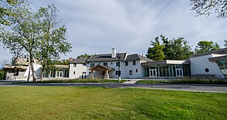
Princess Street is a major arterial road in Kingston, Ontario, Canada. As the main retail street of downtown Kingston, it is lined by many historic limestone buildings in the city's downtown core.

Lemoine Point Conservation Area is a 136-hectare (340-acre) recreational conservation area at the west end of Kingston, Ontario. The area is bordered by Collins Bay on the north and west sides, Lake Ontario on the south and Kingston/Norman Rogers Airport on the east.

Kingston Airfield, in Kingston, Ontario, Canada, operated from 1929–1942 as Kingston's first airport. It consisted of a grass strip and supporting buildings in what is now the Kingscourt subdivision of the city, just to the west of the St. Mary's cemetery. The city of Kingston purchased what was then the Reid Farm and leased it to the Kingston Flying Club, who operated a flight school using two Gipsy Moth aircraft.
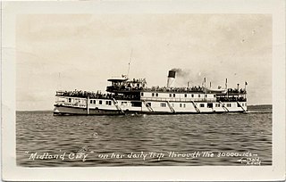
SS Midland City was originally a Canadian side-wheel steamboat that provided passenger and cargo transportation on the Great Lakes from 1871 until 1955. Originally named Maud, then America, she underwent several extensive refits over her 84-year service, and saw several owners. The ship was intentionally run aground and burnt to the waterline in 1955 near the mouth of the Wye River in Midland Bay. The wreck is intact and visible above the water to this day, where it acts as a breakwater for the Wye Heritage Marina and local attraction.
The Cataraqui Region Conservation Authority is one of 36 conservation authorities in the Canadian province of Ontario. It is headquartered in Kingston, Ontario The authority was established by an Order in Council in December 1964 via the Conservation Authorities Act, and is a member authority of Conservation Ontario.
References
- ↑ "Neighbourhood Profile Datasheets". City of Kingston. Archived from the original on 2020-02-20. Retrieved 20 March 2016.