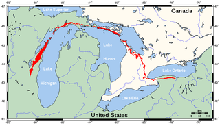
The Niagara Escarpment is a long escarpment, or cuesta, in Canada and the United States that starts from the south shore of Lake Ontario westward, circumscribes the top of the Great Lakes Basin running from New York through Ontario, Michigan, and Wisconsin. The escarpment is the cliff over which the Niagara River plunges at Niagara Falls, for which it is named.
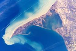
Long Point is a sand spit and medium-sized hamlet on the north shore of Lake Erie, part of Norfolk County in the province of Ontario, Canada.
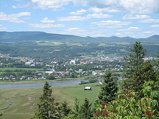
Charlevoix is a cultural and natural region in Quebec, on the north shore of the Saint Lawrence River as well as in the Laurentian Mountains area of the Canadian Shield. This dramatic landscape includes rolling terrain, fjords, headlands, and bays; the region was designated a World Biosphere Reserve by UNESCO in 1989. Administratively, it comprises the Charlevoix and Charlevoix-Est regional county municipalities within the larger Capitale-Nationale administrative region.

Georgian Bay is a large bay of Lake Huron, in the Laurentia bioregion. It is located entirely within the borders of Ontario, Canada. The main body of the bay lies east of the Bruce Peninsula and Manitoulin Island. To its northwest is the North Channel.
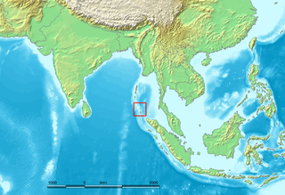
The Nicobar Islands are an archipelagic island chain in the eastern Indian Ocean. They are located in Southeast Asia, 150 kilometres (93 mi) northwest of Aceh on Sumatra, and separated from Thailand to the east by the Andaman Sea. Located 1,300 kilometres (810 mi) southeast of the Indian subcontinent, across the Bay of Bengal, they are part of India, as the Nicobar district within the union territory of the Andaman and Nicobar Islands. Together with the Andaman Islands to their north, the Nicobar Islands serve as a maritime boundary between the Bay of Bengal to the west and the Andaman Sea to the east.

Killbear Provincial Park is a provincial park located on Georgian Bay in the Parry Sound District of Ontario, near the town of Nobel. Killbear combines sandy beaches typical of the Great Lakes with the rock ridges and pines of the Canadian Shield. The park boundaries lie within the Georgian Bay Littoral UNESCO Biosphere Reserve.
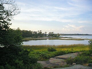
Georgian Bay Islands National Park consists of 63 small islands or parts of islands in Georgian Bay, near Port Severn, Ontario. The total park area is approximately 13.5 km2 (5.2 sq mi). Prior to the creation of Fathom Five National Marine Park, Flowerpot Island was also a part of the park.

Christian Island is a large island in Georgian Bay close to the communities of Penetanguishene and Midland, Ontario. The island, with its neighbours Hope Island and Beckwith Island, is a 5,428.1 hectares Ojibwa reserve, known as Christian Island Indian Reserve No. 30. Together with the 7.5 hectares Christian Island Indian Reserve No. 30A located at Cedar Point, Ontario and the 3.1 hectares Chippewa Island Indian Reserve located in Twelve Mile Sound, 27.5 kilometres (17.1 mi) north of Christian Island, it forms the land base for the Beausoleil First Nation. Christian Islands' highest elevation is 209 metres above sea level.
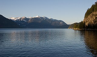
Howe Sound is a roughly triangular sound, that joins a network of fjords situated immediately northwest of Vancouver, British Columbia, Canada. It was designated as a UNESCO Biosphere Reserve in 2021.

There are 18 biosphere reserves in India. They protect larger areas of natural habitat than a typical national park or animal sanctuary, and often include one or more national parks or reserves, along with buffer zones that are open to some economic uses. Protection is granted not only to the flora and fauna of the protected region, but also to the human communities who inhabit these regions, and their ways of life. In total there are 18 biosphere reserves in India.

Beausoleil Island; Île Beausoleil; is an 8-kilometre (5.0 mi) long island in the municipality of Georgian Bay, District Municipality of Muskoka in Central Ontario, Canada. The island is named after Louis Beausoleil, a Métis settler whose 1819 homestead stood at the island's southern tip. The name of the island in the Huron-Wendat language is Skiondechiara which means "The land to appear floating afar". The name of the island in the Anishinaabemowin language is variously Pamedenagog, Baamidoonegog or Epenmindaagoog meaning “rocky place floating about the mouth of a river”. Located in the Thirty Thousand Islands in Georgian Bay on Lake Huron, it is the largest island in Georgian Bay Islands National Park and is the only place in the park where camping is allowed. Beausoleil Island is also part of the Georgian Bay Littoral UNESCO Biosphere reserve.
Under UNESCO’s Man and the Biosphere Programme (MAB), there are 70 biosphere reserves recognized as part of the World Network of Biosphere Reserves in African states as of 2016. These are distributed across 28 countries. While biosphere reserves in West African, East African, Central African and Southern African countries are organised in the AfriMAB regional network, biosphere reserves in Northern African countries are organised in the ArabMAB, UNESCO's regional MAB network.
Under UNESCO’s Man and the Biosphere Programme, there are 308 biosphere reserves recognized as part of the World Network of Biosphere Reserves in Europe and North America. These are distributed across 41 countries in the region.
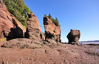
The Fundy Biosphere Region is located next to the upper Bay of Fundy, covering 442,250 hectares in New Brunswick, Canada. The area was named and designated as such by the United Nations Educational, Scientific and Cultural Organization (UNESCO) in 2007.

The Black Sea Biosphere Reserve is a biosphere reserve of Ukraine that is located at littoral zone of the northern Black Sea coast covering regions of the Kherson and Mykolaiv Oblasts and including Gulf of Tendra and Yahorlyk Bay. The reserve is part of the National Academy of Sciences of Ukraine.

North Devon's Biosphere Reserve is a UNESCO biosphere reserve in North Devon. It covers 55 square miles (140 km2) and is centred on Braunton Burrows, the largest sand dune system (psammosere) in England. The boundaries of the reserve follow the edges of the conjoined catchment basin of the Rivers Taw and the Torridge and stretch out to sea to include the island of Lundy. The biosphere reserve is primarily lowland farmland, and includes many protected sites including 63 Sites of Special Scientific Interest which protect habitats such as culm grassland and broadleaved woodlands. The most populous settlements in its buffer area are Barnstaple, Bideford, Northam, Ilfracombe, and Okehampton.

The Niagara Escarpment Biosphere Reserve is a UNESCO Biosphere Reserve located in Ontario, Canada. The reserve stretches 725 kilometres (450 mi) along the Niagara Escarpment from Lake Ontario to the tip of the Bruce Peninsula. The Escarpment corridor crosses two major biomes: needle leaf forests in the north and temperate broadleaf forest in the south.

The Thirty Thousand Islands are the world's largest freshwater archipelago, and are located mainly along the east side of Georgian Bay, part of the Great Lakes, in Ontario, Canada.
UNESCO Biosphere Reserves are environment-protected scientific-research institutions of international status that are created with the intent for conservation in a natural state the most typical natural complexes of biosphere, conducting background ecological monitoring, studying of the surrounding natural environment, its changes under the activity of anthropogenic factors.


