Thirty Thousand Islands

Last updated

The Thirty Thousand Islands are the world's largest freshwater archipelago, and are located mainly along the east side of Georgian Bay, part of the Great Lakes, in Ontario, Canada. [1] [2]

Contents

Biosphere map of Georgian Bay. BIOSPHERE KEY MAP 8x11 Feb28-2019.jpg
Biosphere map of Georgian Bay.

UNESCO designated the area in 2004 as the Georgian Bay Littoral (also called the Georgian Bay Biosphere Reserve). It is an area of 347,000 hectares (860,000 acres) that stretches 200 kilometres (120 mi) along the eastern coast from Port Severn to the French River. [2]

Though the Thirty Thousand Islands has no formal geographical boundaries, its general location runs from Beausoleil Island in the south to the French River Provincial Park in the north. Just a few kilometres west of Beausoleil Island are four more islands – Giants Tomb Island, Hope Island, Beckwith Island, and Christian Island. To the west of French River Provincial Park are many more islands, including Manitoulin Island, the largest freshwater lake island in the world.
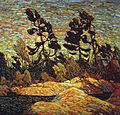
Group of Seven

Many of the Group of Seven landscape paintings feature the Georgian Bay Shoreline and the adjacent windswept islands with their distinctive trees and large boulders, which are characteristic features of the Canadian Shield. Franklin Carmichael, A.Y. Jackson, Arthur Lismer, Frederick Varley, A.J. Casson and Tom Thomson all painted extensively along Georgian Bay. At that time, they came by train as the road to Killarney, Ontario would not be built until four decades later.

Related Research Articles

<span class="mw-page-title-main">Lake Huron</span> One of the Great Lakes of North America

Lake Huron is one of the five Great Lakes of North America. Hydrologically, it comprises the easterly portion of Lake Michigan–Huron, having the same surface elevation as Lake Michigan, to which it is connected by the 5-mile-wide (8.0 km), 20-fathom-deep Straits of Mackinac. It is shared on the north and east by the Canadian province of Ontario and on the south and west by the U.S. state of Michigan. The name of the lake is derived from early French explorers who named it for the Huron people inhabiting the region.

<span class="mw-page-title-main">Lake Winnipeg</span> Large glacial lake in Manitoba, Canada

Lake Winnipeg is a very large, relatively shallow 24,514-square-kilometre (9,465 sq mi) lake in North America, in the province of Manitoba, Canada. Its southern end is about 55 kilometres (34 mi) north of the city of Winnipeg. Lake Winnipeg is Canada's sixth-largest freshwater lake and the third-largest freshwater lake contained entirely within Canada, but it is relatively shallow excluding a narrow 36 m (118 ft) deep channel between the northern and southern basins. It is the eleventh-largest freshwater lake on Earth. The lake's east side has pristine boreal forests and rivers that were in 2018 inscribed as Pimachiowin Aki, a UNESCO World Heritage Site. The lake is 416 km (258 mi) from north to south, with remote sandy beaches, large limestone cliffs, and many bat caves in some areas. Manitoba Hydro uses the lake as one of the largest reservoirs in the world. There are many islands, most of them undeveloped.

<span class="mw-page-title-main">Thousand Islands</span> Archipelago in the Saint Lawrence River

The Thousand Islands constitute a North American archipelago of 1,864 islands that straddles the Canada–US border in the Saint Lawrence River as it emerges from the northeast corner of Lake Ontario. They stretch for about 50 miles (80 km) downstream from Kingston, Ontario. The Canadian islands are in the province of Ontario and the U.S. islands in the state of New York.

<span class="mw-page-title-main">Niagara Escarpment</span> Escarpment in Canada and the United States

The Niagara Escarpment is a long escarpment, or cuesta, in Canada and the United States that runs predominantly east–west from New York through Ontario, Michigan, Wisconsin, and Illinois. The escarpment is most famous as the cliff over which the Niagara River plunges at Niagara Falls, for which it is named.

<span class="mw-page-title-main">Thousand Islands – Frontenac Arch</span> Geologic region in North America

The Thousand Islands – Frontenac Arch region or the Frontenac Axis is an exposed strip of Precambrian rock in Canada and the United States that links the Canadian Shield from Algonquin Park with the Adirondack Mountain region in New York, an extension of the Laurentian mountains of Québec. The Algonquin to Adirondacks region, which includes the Frontenac Axis or Arch, is a critical linkage for biodiversity and resilience, and one with important conservation potential. The axis separates the St. Lawrence Lowlands and the Great Lakes Lowlands. It has many distinctive plant and animal species. It is one of four ecoregions of the Mixedwood Plains.

<span class="mw-page-title-main">Long Point, Ontario</span> Community of Norfolk County, Ontario, Canada

Long Point is a sand spit and medium-sized hamlet on the north shore of Lake Erie, part of Norfolk County in the province of Ontario, Canada.

<span class="mw-page-title-main">Lake Saint Pierre</span> Body of water

Lake Saint Pierre is a lake in Quebec, Canada, a widening of the Saint Lawrence River between Sorel-Tracy and Trois-Rivières. It is located downstream, and northeast, of Montreal; and upstream, and southwest, of Quebec City. The end of the lake delimits the beginning of the estuary of Saint Lawrence.

<span class="mw-page-title-main">Tourism in Canada</span> Overview of tourism in Canada

Canada has a large domestic and foreign tourism industry. The second largest country in the world, Canada's incredible geographical variety is a significant tourist attractor. Much of the country's tourism is centred in the following regions: Toronto, Montreal, Quebec City, Vancouver/Whistler, Niagara Falls, Vancouver Island, Canadian Rockies, British Columbia's Okanagan Valley, Churchill, Manitoba and the national capital region Ottawa. The large cities are known for their culture, diversity, as well as the many national parks and historic sites.

<span class="mw-page-title-main">Georgian Bay</span> Large bay of Lake Huron, Ontario, Canada

Georgian Bay is a large bay of Lake Huron, in the Laurentia bioregion. It is located entirely within the borders of Ontario, Canada. The main body of the bay lies east of the Bruce Peninsula and Manitoulin Island. To its northwest is the North Channel.

<span class="mw-page-title-main">Parry Sound, Ontario</span> Town in Ontario, Canada

Parry Sound is a town in Ontario, Canada, located on the eastern shore of the sound after which it is named. Parry Sound is located 160 km (99 mi) south of Sudbury and 225 km (140 mi) north of Toronto. It is a single tier government located in the territorial District of Parry Sound which has no second tier County, Regional or District level of government. Parry Sound is a popular cottage country region for Southern Ontario residents. It also has the world's deepest natural freshwater port.

<span class="mw-page-title-main">Bruce Peninsula</span> Peninsula in Southern Ontario, Canada

The Bruce Peninsula is a peninsula in Ontario, Canada, that divides Georgian Bay of Lake Huron from the lake's main basin. The peninsula extends roughly northwestwards from the rest of Southwestern Ontario, pointing towards Manitoulin Island, with which it forms the widest strait joining Georgian Bay to the rest of Lake Huron. The Bruce Peninsula contains part of the geological formation known as the Niagara Escarpment.

<span class="mw-page-title-main">Killbear Provincial Park</span> Provincial park in Ontario, Canada

Killbear Provincial Park is a provincial park located on Georgian Bay in the Parry Sound District of Ontario, near the town of Nobel. Killbear combines sandy beaches typical of the Great Lakes with the rock ridges and pines of the Canadian Shield. The park boundaries lie within the Georgian Bay Littoral UNESCO Biosphere Reserve.

<span class="mw-page-title-main">Georgian Bay Islands National Park</span> National park in Ontario, Canada

Georgian Bay Islands National Park consists of 63 small islands or parts of islands in Georgian Bay, near Port Severn, Ontario. The total park area is approximately 13.5 km2 (5.2 sq mi). Prior to the creation of Fathom Five National Marine Park, Flowerpot Island was also a part of the park.

<span class="mw-page-title-main">Christian Island</span>

Christian Island is a large island in Georgian Bay close to the communities of Penetanguishene and Midland, Ontario. The island, with its neighbours Hope Island and Beckwith Island, is a 5,428.1 hectares Ojibwa reserve, known as Christian Island Indian Reserve No. 30. Together with the 7.5 hectares Christian Island Indian Reserve No. 30A located at Cedar Point, Ontario and the 3.1 hectares Chippewa Island Indian Reserve located in Twelve Mile Sound, 27.5 kilometres (17.1 mi) north of Christian Island, it forms the land base for the Beausoleil First Nation. Christian Islands' highest elevation is 209 metres above sea level.

<span class="mw-page-title-main">Protected areas of Canada</span> Areas protected for conservation or historical reasons

Protected areas of Canada consist of approximately 12.1 percent of the nation’s landmass and freshwater are considered conservation areas, including 11.4 percent designated as protected areas. Approximately 13.8 percent of Canada's territorial waters are conserved, including 8.9 percent designated as protected areas. Terrestrial areas conserved have increased by 65 percent in the 21st century, while marine areas conserved have increased by more than 3,800 percent.

<span class="mw-page-title-main">Long Point Provincial Park</span> Provincial park near Port Rowan, Ontario

Long Point Provincial Park is a provincial park on the northwest shore of Lake Erie near Port Rowan, Ontario, Canada. The park is part of a sandy spit of land called Long Point that juts out into the lake. It covers part of the area of Long Point Biosphere Reserve, which was designated a UNESCO Biosphere Reserve because of its biological significance.

<span class="mw-page-title-main">Beausoleil Island</span>

Beausoleil Island; Île Beausoleil; is an 8-kilometre (5.0 mi) long island in the municipality of Georgian Bay, District Municipality of Muskoka in Central Ontario, Canada. The island is named after Louis Beausoleil, a Métis settler whose 1819 homestead stood at the island's southern tip. The name of the island in the Huron-Wendat language is Skiondechiara which means "The land to appear floating afar". Located in the Thirty Thousand Islands in Georgian Bay on Lake Huron, it is the largest island in Georgian Bay Islands National Park and is the only place in the park where camping is allowed. Beausoleil Island is also part of the Georgian Bay Littoral UNESCO Biosphere reserve.

<span class="mw-page-title-main">Tourism in Ontario</span> Tourism opportunities in Ontario, Canada

Ontario is Canada's largest province in population and second largest province in size, covering close to one million square kilometres. It borders the United States to the south, and the provinces of Quebec to the east and Manitoba to the west. Its southernmost point, Middle Island, off Pelee Island, has the same latitude as Rome, Italy. The northernmost point at Ontario-Manitoba border is close to that of London, England, and Warsaw, Poland. Around 250,000 lakes can be found in Ontario, making up approximately one-third of the world's fresh water.

<span class="mw-page-title-main">Georgian Bay Littoral</span> UNESCO Biosphere Reserve in Ontario, Canada

The Georgian Bay Littoral is a UNESCO Biosphere Reserve located in Ontario, Canada. The biosphere was the thirteenth in Canada, and covers the Thirty Thousand Islands area of eastern Georgian Bay, one of the world's largest fresh water archipelagos.

<span class="mw-page-title-main">Niagara Escarpment Biosphere Reserve</span> UNESCO Biosphere Reserve in Ontario, Canada

The Niagara Escarpment Biosphere Reserve is a UNESCO Biosphere Reserve located in Ontario, Canada. The reserve stretches 725 kilometres (450 mi) along the Niagara Escarpment from Lake Ontario to the tip of the Bruce Peninsula. The Escarpment corridor crosses two major biomes: needle leaf forests in the north and temperate broadleaf forest in the south.

References

  1. "Place names - Thirty Thousand Islands". Geographical Names Board of Canada. Government of Canada, Natural Resources Canada, Earth Sciences Sector, Canada Centre for Mapping and Earth. Retrieved 2 June 2017.
  2. 1 2 "Ecological Sciences for Sustainable Development: Georgian Bay". www.unesco.org. United Nations Educational, Scientific and Cultural Organization. Retrieved 2 June 2017.

Coordinates: 45°22′22″N80°25′03″W / 45.3728°N 80.4175°W / 45.3728; -80.4175