Hope Island (Ontario)

Last updated

Ferry terminal in Cedar Point (Tiny, Ontario) to Christian Island, with Hope Island left on the horizon. Hope and Beckwith Islands.JPG
Ferry terminal in Cedar Point (Tiny, Ontario) to Christian Island, with Hope Island left on the horizon.

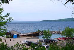
Hope Island is the northern of three islands in south eastern Georgian Bay, of Lake Huron, in the Canadian province of Ontario. It has an elevation of 187 meters (613 feet) above sea level and is currently uninhabited and not presently slated for development. It was named by Henry Bayfield after he surveyed it in the 19th century. Like its neighbours, Beckwith Island and Christian Island, the uninhabited island is part of the Beausoleil First Nation.

Hope Island Lighthouse

In 1884, a lighthouse was placed on the northwest side of the island. Despite this there are a number of wreck sites off the island. Hope Island Lighthouse, Sep. 2015.jpeg

Coordinates: 44°54′18″N80°10′49″W / 44.90500°N 80.18028°W / 44.90500; -80.18028 [1]

Related Research Articles

<span class="mw-page-title-main">Arctic Archipelago</span> Group of islands in the Arctic Ocean, off the coast of northern Canada

The Arctic Archipelago, also known as the Canadian Arctic Archipelago, is an archipelago lying to the north of the Canadian continental mainland, excluding Greenland and Iceland.

Roosevelt Gardens is a census-designated place (CDP) in Broward County, Florida, United States. The population was 2,456 at the 2010 census.

<span class="mw-page-title-main">Turin Township, Michigan</span> Civil township in Michigan, United States

Turin Township is a civil township of Marquette County in the U.S. state of Michigan. As of the 2010 census, the township population was 153.

<span class="mw-page-title-main">Queen Elizabeth Islands</span> Northernmost group of islands of the Canadian Arctic Archipelago

The Queen Elizabeth Islands are the northernmost cluster of islands in Canada's Arctic Archipelago, split between Nunavut and the Northwest Territories in Northern Canada. The Queen Elizabeth Islands contain approximately 14% of the global glacier and ice cap area.

<span class="mw-page-title-main">Christian Island</span>

Christian Island is a large island in Georgian Bay close to the communities of Penetanguishene and Midland, Ontario. The island, with its neighbours Hope Island and Beckwith Island, is a 5,428.1 hectares Ojibwa reserve, known as Christian Island Indian Reserve No. 30. Together with the 7.5 hectares Christian Island Indian Reserve No. 30A located at Cedar Point, Ontario and the 3.1 hectares Chippewa Island Indian Reserve located in Twelve Mile Sound, 27.5 kilometres (17.1 mi) north of Christian Island, it forms the land base for the Beausoleil First Nation. Christian Islands' highest elevation is 209 metres above sea level.

<span class="mw-page-title-main">Eglinton Island</span> Uninhabited island in northern Canada

Eglinton Island an uninhabited island of the Arctic Archipelago in the Northwest Territories, Canada. Eglinton is one of the Queen Elizabeth Islands. Located at 75°48'N 118°30'W, it measures 1,541 km2 (595 sq mi) in size, 73 kilometres (45 mi) long and 44 km (27 mi) wide in measurements. It lies on the north side of the M'Clure Strait, just south of the much larger Prince Patrick Island and is uninhabited with no known human activity.

<span class="mw-page-title-main">Stefansson Island</span> Uninhabited island in the Arctic Archipelago

Stefansson Island is an uninhabited island in the Arctic Archipelago in the Kitikmeot Region of Nunavut, Canada. It has a total area of 4,463 km2 (1,723 sq mi), making it the 128th largest island in the world, and Canada's 27th largest island. The island is located in Viscount Melville Sound, with M'Clintock Channel to the east. It lies just off Victoria Island's Storkerson Peninsula, separated by the Goldsmith Channel. Stefansson Island's highest mount is 256 m (840 ft). A weather station, at 73°45′56″N105°17′44″W, is located on the northern part of the island as part of an automated weather station array operated by Environment and Climate Change Canada in the Arctic. The first European sighting of the island was in 1917 by Storker T. Storkerson who was travelling with Canadian explorer Vilhjalmur Stefansson (1879-1962), for whom the island was named.

<span class="mw-page-title-main">Rowley Island</span> Uninhabited island in Nunavut, Canada

Rowley Island is one of the Canadian Arctic islands in the Qikiqtaaluk Region, Nunavut. It is located in Foxe Basin and has an area of 1,090 km2 (420 sq mi).

The Ottawa Islands are a group of currently uninhabited islands situated in the eastern edge of Canada's Hudson Bay. The group comprises 24 small islands, located at approximately 60N 80W. The main islands include Booth Island, Bronson Island, Eddy Island, Gilmour Island, J. Gordon Island, Pattee Island, and Perley Island. The highest point is on Gilmour Island, which rises to over 1,800 ft (550 m). Located a short distance off the northwest coast of Quebec's Ungava Peninsula, they, like the other coastal islands in Hudson Bay, were historically part of the Northwest Territories, and became Crown Land upon the creation of Nunavut in 1999. Nunavik Inuit have occupied these islands since time immemorial and gained constitutionally-protected harvest and access rights under the Nunavik Inuit Land Claim Agreement signed in 2007.

Hnausa which roughly translates to "uneven ground" is a small community located in the area known as New Iceland in Manitoba's Interlake Region. It is 6 miles, or approximately 10 kilometres, south of Riverton, and is situated on Breidavik on the coast of Lake Winnipeg, in the Rural Municipality of Bifrost. The settlement was founded in the area by 35 Icelandic families in 1876. Hnausa Post Office was set up in 1889 in the home of Rev. Magnus J. Skaptason. Much of the population descended from these immigrants from Iceland.

<span class="mw-page-title-main">Beckwith Island</span>

Beckwith Island is the eastern of three islands in southeastern Georgian Bay in Ontario, Canada. Beckwith Island and the attached "Little Beckwith" are part of the Beausoleil First Nation.

<span class="mw-page-title-main">Cape Hay</span>

Cape Hay is an uninhabited headland on Bylot Island in the Qikiqtaaluk Region of Nunavut, Canada. It is located at the island's northwestern tip, protruding into Lancaster Sound. The Wollaston Islands are offshore.

Valparaiso is a village in the Canadian province of Saskatchewan within the Rural Municipality of Star City No. 428 and Census Division No. 14. The village is located at the junction of Highway 3 and Range Road No. 160, approximately 20 km east of the City of Melfort. The name comes from that of Valparaíso in Chile.

Flirt Rocks are two small, uninhabited, rocky islets off of Anguilla, in the Leeward Islands of the Caribbean. They are located 0.75 miles (1.21 km) north of the Prickly Pear Cays. Seal Reef is situated east of the Flirt Rocks.

O'Reilly Island is an uninhabited island in Nunavut Territory, Canada. It lies to the south of King William Island and to the west of the Klutschak and Adelaide Peninsulas, in the easternmost part of the Queen Maud Gulf.

Lundey is a small, uninhabited island in Skagafjörður fjord located about 2 kilometres (1.2 mi) from the eastern mouth of the Héraðsvötn River, in northern Iceland. It is one of three islands in the bay, the others being Málmey, and Drangey. Lundey is low lying and grassy with an area of approximately 6.3 hectares (0.024 sq mi). The island is about 300 metres (980 ft) long and 100 metres (330 ft) wide. Its name in Icelandic means "Puffin"; And each summer, Atlantic Puffin breed on the island's cliffs hence its name. The island is only accessible by boat and lies approximately 9 kilometres (5.6 mi) from the nearest harbor in the town of Sauðárkrókur. There are two other islands known as Lundey in Iceland; One in Skjálfandi Bay in northern Iceland and another near Reykjavík.

References

  1. "Hope Island". Geographical Names Data Base . Natural Resources Canada . Retrieved November 19, 2010.