
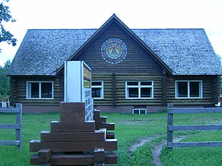
The Chippewas of Georgina Island First Nation are an Ojibwa people located on Georgina Island in Lake Simcoe, Ontario, Canada. In 2008, of the First Nation's registered population of 666 people, 181 lived on, and 485 lived outside, their reserve. As of 2020, the band has a total population of 923 members. They are one of a handful of First Nations in the Toronto Census Metropolitan Area.

Christian Island is a large island in Georgian Bay close to the communities of Penetanguishene and Midland, Ontario. The island, with its neighbours Hope Island and Beckwith Island, is a 5,428.1 hectares Ojibwa reserve, known as Christian Island Indian Reserve No. 30. Together with the 7.5 hectares Christian Island Indian Reserve No. 30A located at Cedar Point, Ontario and the 3.1 hectares Chippewa Island Indian Reserve located in Twelve Mile Sound, 27.5 kilometres (17.1 mi) north of Christian Island, it forms the land base for the Beausoleil First Nation. Christian Islands' highest elevation is 209 metres above sea level.

Zhiibaahaasing First Nation is a First Nation band government in the Canadian province of Ontario. It is a member of the United Chiefs and Councils of Manitoulin.
Garden River First Nation, also known as Ketegaunseebee, is an Ojibwa band located at Garden River 14 near Sault Ste. Marie, Ontario, Canada.
The Wahnapitae First Nation is an Ojibway First Nation band government in the Canadian province of Ontario, who primarily reside on the 1,036-hectare (2,560-acre) Wahnapitae Indian Reserve No. 11 on the northwestern shore of Lake Wanapitei. The First Nation is a signatory to the Robinson-Huron Treaty of 1850 as the Tahgaiwenene's Band. The reserve had a resident population of 102 in the Canada 2011 Census; the First Nation also has approximately 200 further registered members who currently live off-reserve.
Poplar Hill First Nation is an Anishinaabe (Ojibway) First Nation band government, approximately 120 km north of Red Lake near the Ontario-Manitoba border. The First Nation is accessible by air and winter road. In May 2016, the First Nation had a registered population of 473 people.
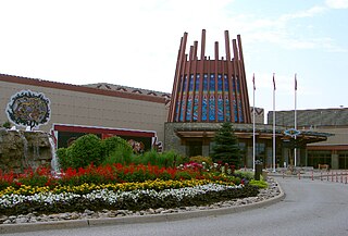
Chippewas of Rama First Nation, also known as Chippewas of Mnjikaning and Chippewas of Rama Mnjikaning First Nation, is an Anishinaabe (Ojibway) First Nation located in the province of Ontario in Canada. The name Mnjikaning, or fully vocalized as Minjikaning, refers to the fishing weirs at Atherley Narrows between Lake Simcoe and Lake Couchiching and it means "in/on/at or near the fence".
Marten Falls First Nation is an Anishinaabe First Nation reserve located in northern Ontario. The First Nation occupies communities on both sides of the Albany River in Northern Ontario, including Ogoki Post in the Cochrane District and Marten Falls in the Kenora District. As of December 2013, the First Nation had a total registered population of 728 people, of which their on-reserve population was 328 people.
Kingfisher First Nation is an Oji-Cree First Nation reserve located 350 kilometres (220 mi) north of Sioux Lookout, Ontario, Canada. It is accessible by air all year and by waterway in summer and ice roads in winter. As of December 2009, the First Nation had a total registered population of 500 people, the on-reserve population being 462. The community speaks the Oji-Cree language, but most of it is fluent in English as well.

Fort William First Nation is an Ojibwa First Nation reserve in Ontario, Canada. The administrative headquarters for this band government is south of Thunder Bay. As of January 2008, the First Nation had a registered population of 1,798 people, of which their on-Reserve population was 832 people.
Lac Seul First Nation is an Ojibwe First Nation band government located on the southeastern shores of Lac Seul, 56 kilometres (35 mi) northeast of the city of Dryden, Ontario. Though Lac Seul First Nation is a treaty signatory to Treaty 3, the First Nation is a member of the Independent First Nations Alliance, a regional tribal council and a member of the Nishnawbe Aski Nation.
Northwest Angle 33 First Nation is an Ojibwe or Ontario Anishinaabe First Nation band government who reside in Kenora District, Ontario near Sioux Narrows of Lake of the Woods.
Nigigoonsiminikaaning First Nation, formerly known as the Nicickousemenecaning First Nation and as the Red Gut First Nation, is a Saulteaux First Nation band government who inhabit the banks of Rainy Lake of the Rainy River District in Northwestern Ontario, Canada. As of January, 2008, the First Nation had a population of 290 registered people. As of 2017, it has approximately 130 on-reserve members.
Lac La Croix First Nation is a Saulteaux First Nation band government who reside in the Rainy River District of northwestern Ontario, Canada, along the Ontario-Minnesota border. It is approximately 200 km northwest of Thunder Bay, Ontario. As of January 2008, the First Nation had a registered population of 398 people, of which their on-Reserve population was 273.

Long Lake 58 First Nation is an Anishinaabe (Ojibway) First Nation band government located in Northern Ontario, located approximately 40 km east of Geraldton, Ontario, Canada, on the northern shore of Long Lake, immediately north of Ginoogaming First Nation and west of the community of Longlac, Ontario. As of January, 2008, their total registered population was 1,248 people, of which their on-Reserve population was 427.
Nipissing First Nation, meaning "place of little waters", is a long-standing community of Nishnaabeg peoples, who traditionally speak Anishinaabemwin, located along the shorelines of Lake Nipissing in northern Ontario. They are referred to by many names in European historical records, since the colonists often adopted names given to them by other nations.
The Naicatchewenin First Nation, also known as the Anishinaabeg of Nagaajiwanaang and formerly known as Northwest Bay First Nation, inhabited a region in Ontario that was cited in the Northwest Angle Treaty of 1873, also known as Treaty 3. Nagaajiwanaang is located approximately 60 kilometres (37 mi) northwest of Fort Frances, with the community of Devlin 50 kilometres (31 mi) to the south on Highway 11. The city of Thunder Bay lies 420 kilometres (260 mi) to the east and Winnipeg is 450 kilometres (280 mi) to the northwest.

Seine River First Nation, previously known as the Rivière la Seine Band, is an Ojibwe First Nation reserve located roughly 300 kilometres (190 mi) west of Thunder Bay, Ontario. As of November 2011, the First Nation had a total registered population of 725, of which 327 lived on their own reserve.
Christian Island 30A is a First Nations reserve in Simcoe County, Ontario. It is one of the reserves of the Beausoleil First Nation. It had a population of 42 in the 2016 Census, up from 36 in the 2011 Census.
Moose Deer Point First Nation is a Potawatomi First Nation in the District Municipality of Muskoka, Ontario. It has a reserve called Moose Point 79. The reserve is located along Twelve Mile Bay.
