
Huntsville is a town in Muskoka. It is located 215 kilometres (134 mi) north of Toronto and 130 kilometres (81 mi) south of North Bay. Of the three big Muskoka towns, it is the largest by population and land area (710.64 km2).
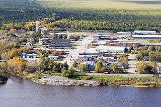
Moosonee is a town in northern Ontario, Canada, on the Moose River approximately 19 km (12 mi) south of James Bay. It is considered to be "the Gateway to the Arctic" and has Ontario's only saltwater port. Nearby on Moose Factory Island is the community of Moose Factory to which it is connected by water taxi in the summer and ice road in the winter.

The District Municipality of Muskoka, more generally referred to as the District of Muskoka or Muskoka, is a regional municipality in Central Ontario, Canada. Muskoka extends from Georgian Bay in the west, to the northern tip of Lake Couchiching in the south, to the western border of Algonquin Provincial Park in the east. A two-hour drive north of Toronto, Muskoka spans 6,475 km2 (2,500 sq mi). Muskoka has some 1,600 lakes, making it a popular cottaging destination.

The Township of Georgian Bay is an area municipality of the District Municipality of Muskoka, in south-central Ontario, Canada. It is located on the Severn River, where it empties into the eponymous Georgian Bay. The municipal offices are at Port Severn.

Wiarton is a community in the town of South Bruce Peninsula, Bruce County, Ontario, Canada. It is located at the western end of Colpoys Bay, an inlet off Georgian Bay, on the Bruce Peninsula.

The Chippewas of Georgina Island First Nation are an Ojibwa people located on Georgina Island in Lake Simcoe, Ontario, Canada. In 2008, of the First Nation's registered population of 666 people, 181 lived on, and 485 lived outside, their reserve. As of 2020, the band has a total population of 923 members. They are one of a handful of First Nations in the Toronto Census Metropolitan Area.

Christian Island is a large island in Georgian Bay close to the communities of Penetanguishene and Midland, Ontario. The island, with its neighbours Hope Island and Beckwith Island, is a 5,428.1 hectares Ojibwa reserve, known as Christian Island Indian Reserve No. 30. Together with the 7.5 hectares Christian Island Indian Reserve No. 30A located at Cedar Point, Ontario and the 3.1 hectares Chippewa Island Indian Reserve located in Twelve Mile Sound, 27.5 kilometres (17.1 mi) north of Christian Island, it forms the land base for the Beausoleil First Nation. Christian Islands' highest elevation is 209 metres above sea level.
Moose Factory is a community in the Cochrane District, Ontario, Canada. It is located on Moose Factory Island, near the mouth of the Moose River, which is at the southern end of James Bay. It was the first English-speaking settlement in lands now making up Ontario and the second Hudson's Bay Company post to be set up in North America after Fort Rupert. On the mainland, across the Moose River, is the nearby community of Moosonee, which is accessible by water taxi in the summer, ice road in the winter, and chartered helicopter in the off-season.

Fort Albany First Nation is a Cree First Nation in Cochrane District in Northeastern Ontario, Canada, within the territory covered by Treaty 9. Situated on the southern shore of the Albany River, Fort Albany First Nation is accessible only by air, water, or by winter road.

The Attawapiskat First Nation is an isolated First Nation located in Kenora District in northern Ontario, Canada, at the mouth of the Attawapiskat River on James Bay. The traditional territory of the Attawapiskat First Nation extends beyond their reserve up the coast to Hudson Bay and hundreds of kilometres inland along river tributaries. The community is connected to other towns along the shore of James Bay by the seasonal ice road/winter road constructed each December, linking it to the towns of Kashechewan First Nation, Fort Albany, and Moosonee Attawapiskat, Fort Albany, and Kashechewan operate and manage the James Bay Winter Road through the jointly owned Kimesskanemenow Corporation, named after the Cree word for "our road" -kimesskanemenow. Attawapiskat is the most remote northerly link on the 310 km (190 mi) road to Moosonee. They control the reserves at Attawapiskat 91 and Attawapiskat 91A.
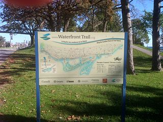
Stretching over 3600 km from Prince Township, west of Sault Ste. Marie, to the Quebec border, the Great Lakes Waterfront Trail is a signed route of interconnecting roads and off-road trails joining over 150 communities and First Nations along the Canadian shores of the Great Lakes and St. Lawrence River. A celebration of nature and culture, the Great Lakes Waterfront Trail is part of a strategy to protect and connect people to the largest group of freshwater lakes on earth. It is a legacy project of the Waterfront Regeneration Trust, a charity, and its community partners. Through Toronto, the trail is called the Martin Goodman Trail. The Waterfront Trail is also used by commuters in parts of Southern Ontario.
The District of North Saanich is located on the Saanich Peninsula of British Columbia, approximately 25 km (16 mi) north of Victoria on southern Vancouver Island. It is one of the 13 Greater Victoria municipalities. The district is surrounded on three sides by 20 km (12 mi) of ocean shoreline, and consists of rural/residential areas, a large agricultural base and is home to the Victoria International Airport and the Swartz Bay Ferry Terminal.

Killarney Provincial Park is a provincial park in central Ontario, Canada.
Gibson Lake is a lake in Georgian Bay Township, District Municipality of Muskoka, Ontario, Canada. It is located 45 minutes north of the city of Barrie, and is accessed by Hwy 400 interchange # 174, just north of Six Mile Lake. Gibson Lake borders on the Wahta Mohawk Territory. The lake is 7 kilometres (4.3 mi) long, and flows into Georgian Bay via the Gibson River. The lake comprises two sections with the narrows connecting the North end to the South end. The southern areas of the lake are popular with cottagers from southern Ontario. The first cottagers purchased property here in the 1950s when the land was originally subdivided. There are presently 200 families on the lake with an increasing number of permanent residents. The north-east side of the lake is dominated by the Sahanatien Native Mohawk reserve which has seen much development in recent years. Many of the cottages on the north-east side are built on land leased from Wahta Mohawk families, and accessed by privately maintained roads.

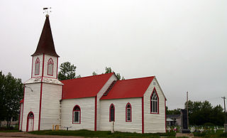
Lion's Head is a community in the municipality of Northern Bruce Peninsula, Bruce County, Ontario, Canada. It is located at the midway point of the Bruce Peninsula, about halfway between Owen Sound and Tobermory, just east of Ferndale on Bruce Road 9. Lion's Head is located on the 45th parallel north, halfway between the Equator and the North Pole. The town is named after the resemblance of a lion's profile in the rock formation of the Niagara Escarpment. The first post office opened in 1895.

Highway 9 is a paved, undivided provincial highway in the Canadian province of Saskatchewan. It runs from North Dakota Highway 8 at the US border near Port of Northgate until it transitions into Provincial Road 283 at the Manitoba provincial boundary.
The Saskota Flyway is known as the International Road to Adventure, because it takes you from Hudson Bay, Saskatchewan, all the way south to Bismarck, North Dakota.
Constance Lake First Nation is an Oji-Cree First Nations band government located on the shores of Constance Lake near Hearst, Cochrane District in northeastern Ontario, Canada. It is directly north of the community of Calstock along a continuation of Ontario Highway 663. Constance Lake First Nation is home to close to 1605 members of Cree and Ojibway with approximately 820 living on reserve. The reserves, Constance Lake 92 and English River 66, total 7,686 acres (3,110 ha) in size.
Dokis 9 is a First Nations reserve and community in the Canadian province of Ontario, assigned to the Dokis First Nation. The reserve is located approximately 16 kilometers southwest of central southern Lake Nipissing along the French River. It is divided into two large parts consisting of a north island, Okikendawt, and a large southern peninsula. The two land masses, which are nestled within the flows of the French river, covers 154.36 square kilometers. The French River watershed in Northern Ontario was created more than ten thousand years ago when the last ice-age receded and left a maze of rivers and small lakes. The main settlement is found on Okikendawt island which can be accessed by a gravel road which connects with Highway 64. The Land is occupied by the Dokis and its cousin tribe, the Restoule‘s. The land is well known for its hunting, fishing, fur trades, and timber.
Beausoleil First Nation is an Ojibwe First Nation band government located in Simcoe County, Ontario, Canada. The main settlement of the Beausoleil First Nation is on Christian Island, Ontario, Canada in southern Georgian Bay. As of 2018, the total number of status Native Americans registered with the First Nation is 2,587. The on-reserve population is 614.
Moose Mountain Upland, Moose Mountain Uplands, or commonly Moose Mountain, is a hilly plateau located in the south-east corner of the Canadian province of Saskatchewan, that covers an area of about 13,000 km2 (5,000 sq mi). The upland rises about 200 m (660 ft) above the broad, flat prairie which is about 600 m (2,000 ft) above sea level. The highest peak is "Moose Mountain" at 830 m (2,720 ft) above sea level. The area was named Moose Mountain because of the large number of moose that lived in the area. When it was originally used by fur traders, Métis, and the Indigenous peoples, the plateau was called Montagne a la Bosse, which is French for "The Mountain of The Bump or Knob."
