Muskoka Lakes

Last updated

Muskoka Lakes
Township of Muskoka Lakes
3 Mile Lake.jpg
3 Mile Lake: typical lake scene in Muskoka Lakes
Canada Southern Ontario location map 2.png
Red pog.svg
Muskoka Lakes
Coordinates: 45°07′N79°35′W / 45.117°N 79.583°W / 45.117; -79.583
Country Flag of Canada (Pantone).svg  Canada
Province Flag of Ontario.svg Ontario
Regional Municipality Muskoka
Settled1870s
IncorporatedJanuary 1, 1971
Government
  TypeTownship
  MayorPeter Kelley [1]
  Governing BodyMuskoka Lakes Township Council
   MP Scott Aitchison
   MPP Norm Miller (OPC)
Area
[2]
  Land774.46 km2 (299.02 sq mi)
Population
 (2021) [2]
  Total
7,652
  Density9.9/km2 (26/sq mi)
Time zone UTC-5 (EST)
  Summer (DST) UTC-4 (EDT)
Postal code FSA
P0B
Area codes 705, 249
Website www.muskokalakes.ca OOjs UI icon edit-ltr-progressive.svg

The Township of Muskoka Lakes is a municipality of the District Municipality of Muskoka, Ontario, Canada. It has a year-round population of 7,652. [2]

Contents

The municipal offices are located in Port Carling.

History

1929 Canadian National Railway advertisement Muskoka Lakes Ontario Canada, Canadian National - Largest Railway System in America -- Canadien National - Le plus important reseau de chemins de fer en Amerique (cropped).jpg
1929 Canadian National Railway advertisement

The area now covered by the township was opened for settlement and organized in 1870 into the following geographic (and sometime municipal) townships of Watt, Cardwell, Humphrey, Christie, Medora and Wood.

On January 1, 1971, the municipality was established when Cardwell Township, Watt Township, parts of Medora and Wood Townships, and part of Monck Township were merged, along with Town of Bala, Village of Port Carling, and the Village of Windermere, as part of the district's reorganization. [3]

Geography

The township is located on the Canadian Shield and the area is marked by outcrops of igneous rock and evergreen trees. Although inland from both Lake Huron's Georgian Bay and Lake Simcoe, the township contains the Muskoka Lakes consisting of Lake Muskoka, Lake Rosseau and Lake Joseph, along with many other smaller lakes.

Protected areas in Muskoka Lakes include Hardy Lake Provincial Park and Torrance Barrens Conservation Area.

Communities

The township contains the communities of:

  • Bala
  • Bala Park
  • Bardsville
  • Barlochan
  • Beaumaris
  • Baysville
  • Bear Cave
  • Beatrice
  • Bent River
  • Brackenrig
  • Cedar Village
  • Dee Bank
  • Dixon's Corners
  • Dudley
  • Duffy
  • Echo Beach
  • Ferndale
  • Foot's Bay
  • Glen Orchard
  • Gregory
  • Gull Rock
  • Hekkla
  • Inverness Lodge
  • Juddhaven
  • Mendora
  • Milford Bay
  • Minett
  • Morinus
  • Mortimers Point
  • Park Beach
  • Port Carling
  • Port Keewaydin
  • Port Sandfield
  • Raymond
  • Redwood
  • Roderick
  • Rossclair
  • Rosseau Falls
  • Rostrevor
  • Shannon Hall
  • Sunset Beach
  • Thorel House
  • Tomelin Bluffs
  • Torrance
  • Ufford
  • Ullswater
  • Valley Green Beach
  • Walkers Point
  • Willow Beach
  • Whiteside
  • Windermere
  • Woodington
  • Woodward Station
  • Ziska

Climate

Climate data for Beatrice (1981−2010)
MonthJanFebMarAprMayJunJulAugSepOctNovDecYear
Record high °C (°F)11.0
(51.8)
12.5
(54.5)
21.0
(69.8)
31.0
(87.8)
32.0
(89.6)
33.0
(91.4)
33.0
(91.4)
32.5
(90.5)
31.5
(88.7)
27.0
(80.6)
19.0
(66.2)
16.5
(61.7)
33.0
(91.4)
Mean daily maximum °C (°F)−5.0
(23.0)
−2.5
(27.5)
2.4
(36.3)
10.7
(51.3)
18.1
(64.6)
22.6
(72.7)
24.9
(76.8)
23.8
(74.8)
19.3
(66.7)
12.1
(53.8)
4.7
(40.5)
−1.5
(29.3)
10.8
(51.4)
Daily mean °C (°F)−10.7
(12.7)
−8.7
(16.3)
−3.8
(25.2)
4.4
(39.9)
11.0
(51.8)
15.8
(60.4)
18.2
(64.8)
17.3
(63.1)
13.1
(55.6)
6.8
(44.2)
0.4
(32.7)
−6.4
(20.5)
4.8
(40.6)
Mean daily minimum °C (°F)−16.3
(2.7)
−14.9
(5.2)
−10.1
(13.8)
−2.0
(28.4)
3.9
(39.0)
8.9
(48.0)
11.4
(52.5)
10.7
(51.3)
6.8
(44.2)
1.3
(34.3)
−3.9
(25.0)
−11.2
(11.8)
−1.3
(29.7)
Record low °C (°F)−42.5
(−44.5)
−38.0
(−36.4)
−36.0
(−32.8)
−21.0
(−5.8)
−8.5
(16.7)
−4.0
(24.8)
−0.5
(31.1)
−3.5
(25.7)
−7.0
(19.4)
−11.0
(12.2)
−26.0
(−14.8)
−41.5
(−42.7)
−42.5
(−44.5)
Average precipitation mm (inches)114.6
(4.51)
82.5
(3.25)
75.2
(2.96)
76.8
(3.02)
97.9
(3.85)
87.7
(3.45)
94.3
(3.71)
87.7
(3.45)
113.6
(4.47)
118.4
(4.66)
124.0
(4.88)
125.0
(4.92)
1,197.7
(47.15)
Average rainfall mm (inches)28.3
(1.11)
22.9
(0.90)
39.6
(1.56)
66.4
(2.61)
97.7
(3.85)
87.7
(3.45)
94.3
(3.71)
87.7
(3.45)
113.6
(4.47)
114.1
(4.49)
87.3
(3.44)
37.0
(1.46)
876.7
(34.52)
Average snowfall cm (inches)86.4
(34.0)
59.6
(23.5)
35.6
(14.0)
10.4
(4.1)
0.2
(0.1)
0.0
(0.0)
0.0
(0.0)
0.0
(0.0)
0.0
(0.0)
4.3
(1.7)
36.6
(14.4)
88.0
(34.6)
321.1
(126.4)
Average precipitation days (≥ 0.2 mm)17.413.512.012.413.813.311.912.914.417.016.817.3172.6
Average rainy days (≥ 0.2 mm)3.63.45.910.713.813.311.912.914.416.411.95.4123.4
Average snowy days (≥ 0.2 cm)15.211.37.42.70.080.00.00.00.01.35.913.457.2
Source: Environment Canada [4]

Demographics

In the 2021 Census of Population conducted by Statistics Canada, Muskoka Lakes had a population of 7,652 living in 3,529 of its 9,443 total private dwellings, a change of 16.2% from its 2016 population of 6,588. With a land area of 774.46 km2 (299.02 sq mi), it had a population density of 9.9/km2 (25.6/sq mi) in 2021. [2]

Canada census – Muskoka Lakes community profile
2021 2016 2011
Population7,652 (+16.2% from 2016)6588 (-1.8% from 2011)6707 (3.7% from 2006)
Land area774.46 km2 (299.02 sq mi)794.26 km2 (306.67 sq mi)794.48 km2 (306.75 sq mi)
Population density9.9/km2 (26/sq mi)8.3/km2 (21/sq mi)8.4/km2 (22/sq mi)
Median age57.2 (M: 56.8, F: 57.2)54.7 (M: 54.3, F: 5.2)
Private dwellings9,443 (total)  3,529 (occupied)9343 (total) 9723 (total) 
Median household income$89,000
References: 2021 [5] 2016 [6] 2011 [7]
Historical census populations – Muskoka Lakes
YearPop.±%
1971 4,170    
1976 4,813+15.4%
1981 4,968+3.2%
1986 4,948−0.4%
1991 5,498+11.1%
1996 6,061+10.2%
YearPop.±%
2001 6,042−0.3%
2006 6,467+7.0%
2011 6,707+3.7%
2016 6,588−1.8%
2021 7,652+16.2%
2011 Population figure based on revised count. Population counts are not adjusted for boundary changes.
Source: Statistics Canada [2] [3]

Economy

Timber was initially the greatest economic attraction for the region. The soil is poor and rocky and consequently is not especially suited to agriculture.

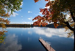
As the resource industries dried up, the area soon embraced tourism as its economic base because of its proximity to Toronto and the rest of Southern Ontario. For many Ontarians, this is the centre of cottage country.

The Muskoka Lakes Township Public Libraries offers research, literature, and cultural resources to local residents. The libraries consist of the Norma and Miller Alloway Muskoka Lakes Library main branch in the town of Port Carling, and three small branches housed in the community centres of Bala, Milford Bay, and Walker's Point.

Government

Muskoka is governed by an elected Town Council consisting of a Mayor, District Councillors and Councillors representing each of the town's three wards. In addition, three Regional Councillors each represent a ward each. The Mayor and Councillors sit on the Muskoka County Council.

Notable people

See also

References

  1. "Certificate of Election Results". Township of Muskoka Lakes. Retrieved 2018-12-05.
  2. 1 2 3 4 5 "Muskoka Lakes (Code 3544053) Census Profile". 2021 census . Government of Canada - Statistics Canada . Retrieved 2025-08-12.
  3. 1 2 "1971 Census of Canada - Population Census Subdivisions (Historical)". Catalogue 92-702 Vol I, part 1 (Bulletin 1.1-2). Statistics Canada. July 1973.
  4. "Beatrice 2, Ontario". Canadian Climate Normals 1981–2010. Environment Canada. 25 September 2013. Archived from the original on July 25, 2019. Retrieved July 25, 2019.
  5. "2021 Community Profiles". 2021 Canadian census . Statistics Canada. February 4, 2022. Retrieved 2022-04-27.
  6. "2016 Community Profiles". 2016 Canadian census . Statistics Canada. August 12, 2021. Retrieved 2019-02-26.
  7. "2011 Community Profiles". 2011 Canadian census . Statistics Canada. March 21, 2019. Retrieved 2012-03-07.