Georgian Bay, Ontario

Last updated

Georgian Bay
Township of Georgian Bay
Georgian Bay Twp.JPG
Canada Southern Ontario location map 2.png
Red pog.svg
Georgian Bay
Coordinates: 44°59′N79°49′W / 44.983°N 79.817°W / 44.983; -79.817
Country Flag of Canada (Pantone).svg  Canada
Province Flag of Ontario.svg  Ontario
District municipality Muskoka
Government
  TypeTownship
  MayorPeter Koetsier [1]
  Governing BodyGeorgian Bay Township Council
   MP Scott Aitchison  (CPC)
   MPP Norm Miller  (OPC)
Area
[2]
  Land547.61 km2 (211.43 sq mi)
Population
 (2016) [3]
  Total2,499
  Density4.6/km2 (12/sq mi)
Time zone UTC-5 (EST)
  Summer (DST) UTC-4 (EDT)
Postal code span
L0K
Area code(s) 705, 249
Website www.gbtownship.ca

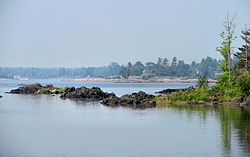
The Township of Georgian Bay is an area municipality of the District Municipality of Muskoka, in south-central Ontario, Canada. It is located on the Severn River, where it empties into the eponymous Georgian Bay. The municipal offices are at Port Severn.

Contents

This township is the administrative centre of the Moose Deer Point Ojibway First Nation reserve.

Local Government

Georgian Bay is governed by a mayor, two district councillors and four councillors, with each councillor representing each of the four municipal wards. The Mayor of Georgian Bay represents the town on the Muskoka County Council. As of the 2022 election, the elected council members are: [4]

Mayor: Peter Koetsier

District Councillors:

Councillors:

Communities

Little Bluff Conservation Area in South Bay Little Bluff conservation.jpg
Little Bluff Conservation Area in South Bay

The township contains the communities of Bayview Park, Big Chute, Cedar Nook, Crooked Bay, Franceville, Go Home, Honey Harbour, Macey Bay, MacTier, Moon River, Potters Landing, South Bay, Wolverine Beach and Wood Landing.

Honey Harbour serves as a launching point to the "30,000 Islands" that make up the Georgian Bay geography. The islands, that are accessible from Honey Harbour, are dotted with hundreds to thousands of cottages. The cottages serve mostly as summer residences. Many very large cottages have been built recently, which has resulted in an increase in property values. The economic cycle of Honey Harbour is tied to the cycle of the cottagers. Honey Harbour has a small grocery store ("Towne Centre" and Picnic Island Resort, which features its own general store and gas bar), a post office, a liquor store, a bakery, a Catholic church and school, a public elementary school, several small craft stores, a large resort (the "Delawana Resort"), and several marinas. In addition to cottages, there are multiple waterfront trailer park resorts. There are also numerous clean beaches lining both the shore and islands, inhabited by the diverse Ontario wildlife.

The double H's of Honey Harbour are a play on founder's name Harvey Hewitt of Pasadena, California. Hewitt was also the original pioneer and co-developer of Woolite.

Demographics

In the 2021 Census of Population conducted by Statistics Canada, Georgian Bay had a population of 3,441 living in 1,660 of its 5,175 total private dwellings, a change of 36.9% from its 2016 population of 2,514. With a land area of 525.29 km2 (202.82 sq mi), it had a population density of 6.6/km2 (17.0/sq mi) in 2021. [5]

Canada census – Georgian Bay community profile
2021 2016 2011
Population3,441 (+36.9% from 2016)2,499 (0.7% from 2011)2,482 [6] (6.1% from 2006)
Land area525.29 km2 (202.82 sq mi)547.61 km2 (211.43 sq mi)546.97 km2 (211.19 sq mi)
Population density6.6/km2 (17/sq mi)4.6/km2 (12/sq mi)4.5/km2 (12/sq mi)
Median age58.4 (M: 58.4, F: 58.4)56.2 (M: 55.9, F: 56.4)
Private dwellings5,175 (total)  1,660 (occupied)4,700 (total) 5,173 [6] (total) 
Median household income$82,000$59,981
References: 2021 [7] 2016 [8] 2011 [9] earlier [10] [11]

Water bodies

Culture

Library

There are library branches in Honey Harbour and MacTier, and a satellite library branch in the new Township Community Services Building in Port Severn. These libraries are popular destinations for recreational reading materials, DVDs, and tourist information. Services include information and reference services, access to full text databases, community information; internet access, reader's advisory services, programs for children, youth and adults, delivery to homebound individuals, interlibrary loan, and free downloadable audiobooks.

Items within the libraries' collection are business directories, phone books, maps, government publications, books, periodicals, genealogy, local history.

Transportation

Intercity motor coach service to MacTier is available through Ontario Northland along its Toronto–Barrie–Parry Sound–Sudbury route's local schedule; it is bypassed by express schedules, but still receives twice-daily service northbound and southbound.

See also

Related Research Articles

<span class="mw-page-title-main">Huntsville, Ontario</span> Town in Muskoka, Canada

Huntsville is a town in Muskoka. It is located 215 kilometres (134 mi) north of Toronto and 130 kilometres (81 mi) south of North Bay. Of the three big Muskoka towns, it is the largest by population and land area (710.64 km2).

<span class="mw-page-title-main">Gravenhurst, Ontario</span> Town in Ontario, Canada

Gravenhurst is a town in the Muskoka Region of Ontario, Canada. It is located approximately 15 kilometres (9.3 mi) south of Bracebridge, Ontario. The Town of Gravenhurst includes a large area of the District of Muskoka, known to Ontarians as "cottage country." The town centre borders on two lakes: Lake Muskoka, which is the largest lake in the region, and Gull Lake, a smaller cottage-bordered lake. Another lake, Kahshe Lake, is situated 10 kilometres (6.2 mi) south of the town.

<span class="mw-page-title-main">Brock, Ontario</span> Township in Ontario, Canada

Brock is a township in the Regional Municipality of Durham, Ontario, Canada. Brock Township is also a former municipality and geographic township prior to the amalgamation that formed the current municipality.

<span class="mw-page-title-main">Kawartha Lakes</span> City in Ontario, Canada

The City of Kawartha Lakes is a unitary municipality in Central Ontario, Canada. It is a municipality legally structured as a single-tier city; however, Kawartha Lakes is the size of a typical Ontario county and is mostly rural. It is the second largest single-tier municipality in Ontario by land area.

<span class="mw-page-title-main">Innisfil</span> Town in Ontario, Canada

Innisfil is a town in Ontario, Canada, located on the western shore of Lake Simcoe in Simcoe County, immediately south of Barrie and 80 kilometres (50 mi) north of Toronto. It has historically been a rural area, but since it is geographically sandwiched between the high-growth areas of Barrie and the York Region, there has been growing residential development in Innisfil.

<span class="mw-page-title-main">District Municipality of Muskoka</span> Regional municipality in Ontario, Canada

The District Municipality of Muskoka, more generally referred to as the District of Muskoka or Muskoka, is a regional municipality in Central Ontario, Canada. Muskoka extends from Georgian Bay in the west, to the northern tip of Lake Couchiching in the south, to the western border of Algonquin Provincial Park in the east. A two-hour drive north of Toronto, Muskoka spans 6,475 km2 (2,500 sq mi). Muskoka has some 1,600 lakes, making it a popular cottaging destination.

<span class="mw-page-title-main">Essa, Ontario</span> Township in Ontario, Canada

Essa is a township in Ontario, Canada, west and south of the city of Barrie in Simcoe County. It is bounded by County Road 90 to its north, County Road 27 to its east, and Ontario Highway 89 to its south. The township is about 100 kilometres (62 mi) from Toronto. The township is well known for its agriculture industry, particularly potato farming. Nearby CFB Borden brings a strong military presence to the area as well, including a high number of Francophone families.

<span class="mw-page-title-main">Lake of Bays</span> Township municipality in Ontario, Canada

Lake of Bays is a township municipality within the District Municipality of Muskoka, Ontario, Canada. The township, situated 193 kilometres (120 mi) north of Toronto, is named after the Lake of Bays. During the 2016 census, the township had a population of 3,167 and encompassed 677.91 square kilometres (261.74 sq mi) of land.

<span class="mw-page-title-main">Muskoka Lakes</span> Township in Ontario, Canada

The Township of Muskoka Lakes is a municipality of the District Municipality of Muskoka, Ontario, Canada. It has a year-round population of 6,588.

<span class="mw-page-title-main">Carling, Ontario</span> Township in Ontario, Canada

Carling is a township in Ontario, Canada, located in the District of Parry Sound on Georgian Bay. Killbear Provincial Park is located in the municipality.

<span class="mw-page-title-main">Simcoe County</span> County in Ontario, Canada

Simcoe County is located in the central portion of Southern Ontario, Canada. The county is just north of the Greater Toronto Area, stretching from the shores of Lake Simcoe in the east to Georgian Bay in the west. Simcoe County forms part of the Greater Golden Horseshoe area, a densely populated and industrialized region, centred on the Greater Toronto Area.

<span class="mw-page-title-main">Douro-Dummer</span> Township in Ontario, Canada

Douro-Dummer is a township in central-eastern Ontario, Canada, in Peterborough County along the Trent-Severn Waterway. It was formed on January 1, 1998, through the amalgamation of Douro and Dummer Townships.

<span class="mw-page-title-main">Ramara</span> Township in Ontario, Canada

Ramara is a lower-tier township municipality in Simcoe County, Ontario, Canada.

<span class="mw-page-title-main">Oro-Medonte</span> Township in Simcoe County, Ontario

Oro-Medonte is a township in south-central Ontario, Canada, on the northwestern shores of Lake Simcoe in Simcoe County.

<span class="mw-page-title-main">The Archipelago</span> Township in Ontario, Canada

The Archipelago is a township in central Ontario, Canada, along the Georgian Bay in the Parry Sound District.

<span class="mw-page-title-main">Burk's Falls</span> Village in Ontario, Canada

Burk's Falls is an incorporated village in the Almaguin Highlands region of Parry Sound District, Ontario, Canada, located 265 kilometres (165 mi) north of Toronto and 90 kilometres (56 mi) south of North Bay, Ontario. The village, and the waterfall on the site, were named by David Francis Burk of Oshawa, after he selected the land surrounding the waterfall in the Free Land Grant Act. Burk's Falls is part of the Magnetawan River waterway.

<span class="mw-page-title-main">Trent Lakes</span> Municipality in Ontario, Canada

The Municipality of Trent Lakes is a lower-tier township in the rural, mostly wooded northern section of Peterborough County, Ontario, Canada. The municipality has a primarily cottage and tourist industry based economy but has grown year round residency due to its commute distance to the Greater Toronto Area.

<span class="mw-page-title-main">Minden Hills</span> Township in Ontario, Canada

Minden Hills is a township in and the county seat of Haliburton County, Ontario, Canada. It is an amalgam of the townships of Snowdon, Lutterworth, Anson, Hindon and Minden. It is usually referred to as Minden, after its largest community.

<span class="mw-page-title-main">Shuniah</span> Municipality in Ontario, Canada

Shuniah is a municipal township bordering the city of Thunder Bay, Ontario, Canada on the east. Shuniah was incorporated by an act of the Ontario legislature in 1873, and at that time included much of present-day Thunder Bay and its predecessor and surrounding municipalities. It gradually shrunk in size until by 1936 it included only three wards, the geographic townships of McIntyre, McGregor, and McTavish. That year it had the Ontario Legislative Assembly remove a number of islands in Lake Superior that had formed the Island Ward since 1873. In 1970 McIntyre Township was amalgamated into the city of Thunder Bay. Shuniah, named after the Ojibwa word "zhooniyaa" for "money" or "silver", was settled largely due to silver mining potential identified in the mid-19th century.

<span class="mw-page-title-main">Magnetawan</span> Municipality in Ontario, Canada

Magnetawan is a township in the Almaguin Highlands region of the Parry Sound District in the Canadian province of Ontario, as well as the name of the primary population centre in the township.

References

  1. "Certificate of Election Results" (PDF). Township of Georgian Bay. Retrieved 2018-11-26.
  2. "Georgian Bay census profile". 2011 Census of Population . Statistics Canada. Retrieved 2012-03-07.
  3. "Census Profile, 2016 Census: Georgian Bay, Township". Statistics Canada. Retrieved June 21, 2019.
  4. "Certificate of Election Results" (PDF). www.gbtownship.ca. October 24, 2022. Retrieved November 22, 2022.
  5. "Population and dwelling counts: Canada, provinces and territories, census divisions and census subdivisions (municipalities), Ontario". Statistics Canada. February 9, 2022. Retrieved April 2, 2022.
  6. 1 2 "Corrections and updates: Population and dwelling count amendments, 2011 Census". Statistics Canada. February 14, 2013. Retrieved February 15, 2013.
  7. "2021 Community Profiles". 2021 Canadian Census . Statistics Canada. February 4, 2022. Retrieved 2023-10-19.
  8. "2016 Community Profiles". 2016 Canadian Census . Statistics Canada. August 12, 2021. Retrieved 2019-06-21.
  9. "2011 Community Profiles". 2011 Canadian Census . Statistics Canada. March 21, 2019. Retrieved 2012-03-07.
  10. "2006 Community Profiles". 2006 Canadian Census . Statistics Canada. August 20, 2019.
  11. "2001 Community Profiles". 2001 Canadian Census . Statistics Canada. July 18, 2021.