Chippewas of Rama First Nation

Last updated

Casino Rama Casino Rama.JPG
Casino Rama
Mnjikaning Arena Sports Ki Mnjikaning Arena Sports Ki.jpg
Mnjikaning Arena Sports Ki

Chippewas of Rama First Nation, also known as Chippewas of Mnjikaning and Chippewas of Rama Mnjikaning First Nation (Ojibwe : Mnjikaning Anishinaabek, also alternatively Rama Anishinaabek), is an Anishinaabe (Ojibway) First Nation located in the province of Ontario in Canada. The name Mnjikaning, or fully vocalized as Minjikaning, refers to the fishing weirs at Atherley Narrows between Lake Simcoe and Lake Couchiching and it means "in/on/at or near the fence".

Contents

Rama is one of the Williams Treaties First Nations which consists of Rama, Beausoleil, Georgina Island, Scugog Island, Curve Lake, Hiawatha and Alderville. Together these Nations have a large Treaty area comprising Treaty 18, 16, 5, 20, 27, 27 1/4, Crawford Purchase and the Gunshot Treaty.

Rama sits on approximately 2,350 acres (951 ha) of land on eight separate parcels. It was once known as Mnjikaning and Rama Mnjikaning but after a community referendum has since re-assumed the name of Chippewas of Rama First Nation. There are 1600 members with approximately 700 living on the reserve and about 900 living off the reserve.

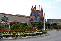
The First Nation is adjacent to a 4,500-year-old wooden stake fishing weir system which at one time sustained many Native peoples but it is not clear who actually built this structure. The First Nation's main reserve, the 908.4 hectares (2,245 acres) Mnjikaning First Nation 32 Indian Reserve, is located approximately 5 kilometres (3 mi) northeast of Orillia, Ontario. Rama First Nation is geographically located within the Township of Ramara, but functions separately. Rama First Nation is also home to 195,000-square-foot (18,100 m2) Casino Rama and Entertainment Complex.

The people are descendants of the Chippewas of Lakes Huron and Simcoe (1800s) and were part of the Coldwater (1836) experiment before settling on the eastern shores of Lake Couchiching. While the ancestors used clan markings/drawings for signatures, original family names were replaced with English names. Many of the families currently living on and off the reserve include these original family names such as Benson, Ingersoll, Williams, Douglas, Shilling, Simcoe, Snache, St. Germain, Stinson, Yellowhead, Sandy, Sawyer, Anderson, Joe and York. Some later name additions (mainly due to marriage) include Comego, Cottrell, Cote, Desormeaux, Genno, Noganosh, Muir, Stiles, Watson, Graham, McPhee, McRae, Palmer and others.[ citation needed ]

History/Origins

Arriving to the area during the Great Anishinaabe migration, the Chippewas of Lakes Huron and Simcoe briefly migrated north during conflict with the Haudenosaunee during the Beaver Wars. Following resolution of the Beaver Wars and the creation of the Dish With One Spoon Wampum Belt, the Chippewas of Lakes Huron and Simcoe returned to Mnjikaning. [1] The Chippewas of Lakes Huron and Simcoe occupied, at their greatest known extent, the lands surrounding Lake Simcoe and the Holland River watershed, extending westwards to encompass roughly present-day Simcoe County. Over a twenty-year span beginning in 1798, their leaders ceded the country west of the lake to the government of Upper Canada via three separate purchase agreements—the Penetanguishene Bay Purchase (1798), the Lake Simcoe–Lake Huron Purchase (1815) and the South Simcoe Purchase (1818). In 1828 the Chippewas numbered approximately "550 souls" under the leadership of "Chief Yellow Head"—the same "Musquakie or Yellow Head, Chief of the Rein Deer Tribe", who was involved in the Lake Simcoe-Lake Huron Purchase and the South Simcoe Purchase. They still occupied their remaining lands about Lake Simcoe and the Holland River, and reportedly had "expressed a strong desire to be admitted to Christianity, and to adopt the habits of civilized life". [2]

In 1830, Musquakie/Yellowhead and his people were induced by agents of Lieutenant Governor John Colborne to settle in two purpose-built villages, one at the Atherley Narrows between Lakes Simcoe and Couchiching, and the other at Coldwater, between which they cleared a road on his instructions. Colborne began paying the Chippewas an annuity and identified "three islands set apart for them", but it was his hope that they would soon take to farming, the village of Orillia having been established by white settlers brought there to teach them European farming techniques. [3] In a surviving letter to Colborne dated September 1830, Yellowhead and four other leaders spoke of their gladness at receiving "the money you sent us" for clearing the road, asking however "when you can pay us the remainder". [4] Just six years later, Lieutenant Governor Francis Bond Head persuaded the Chippewas to give up this country "[rather] than to continue [living] on it, surrounded as it was by the White Population, and consequently deprived as it was of its Game". [5] Musquakie/Yellowhead and his chiefs afterwards objected to this Simcoe-Coldwater Purchase, writing to Governor General Charles Bagot in 1842 that "we were not made sensible of the full purport" of the deal, which paid them only one-third of the proceeds of the sale, and complaining that "we have not received any money from the sale of the said Land". [6] Bond Head had hidden from the Chippewas his intention to sell the land, lot by lot, to white settlers and to forward the proceeds to them as they were generated. Their petition of 1842 received a sympathetic hearing: as they had asked, the proceeds of the piecemeal sales of their former land were banked, and the Chippewas received an annual income from the interest. [7]

As a consequence of the Simcoe-Coldwater Purchase, the Chippewas had to abandon the villages built for them by Colborne in 1830. The Coldwater band relocated to Beausoleil Island in Georgian Bay, whereas, in 1838, the main band at the Atherley Narrows relocated to Rama, where they had obtained 1600 acres of land "purchased out of their own funds" at a cost of $3200. [8] The population of the new settlement was calculated in 1858 to be 201 persons, and its inhabitants' annual revenue from land purchases was $1894.21. [9] Notwithstanding this income, a government report of 1858 commented on the "lamentable" conditions of life among the Chippewas of Rama, observing that, owing to government neglect, "the log houses built for them ... being badly constructed, are all going to decay", that farming was not being taken up, and that the residents "are dragging through a life disgraceful to humanity". [10] Indebtedness to white traders accounts for some of the settlement's early economic woes. In 1839, Musquakie/Yellowhead and two of his chiefs wrote to the Indian Department, that, as soon as Rama was up and running, they intended "to go and hunt in order to pay our debts to those we have been so long owing". [11]

Musquakie/Yellowhead, also known as William Yellowhead, died on 11 January 1864. In his will, which the government declared invalid, he appointed his nephew Isaac Yellowhead to succeed him as "Head Chief of the Chippewa tribe of Indians", but it was Joseph B. Naingishkung who succeeded him. [12]

Governance

The First Nation's leadership consists of a chief and six councillors, elected under the Indian Act Electoral System put into place in the 1930s by Canada in the attempt to depose hereditary chiefs and headman as leaders. The current elected leadership (2014-2016) is Chief Rodney Noganosh and Councillors Ronald Douglas, Ted Williams, Tracey Snache, Nemke Quarrington, and Gina Genno. A by-election held in January 2015 elected a sixth councillor, Ted Snache. [13] The First Nation is a member of Ogemawahj Tribal Council, a regional Chiefs' council, and in June 2016 rejoined the Union of Ontario Indians/Anishinabek Nation. Rama is also a part of the Chippewa Tri-Council which consists of Beausoleil First Nation and the Chippewas of Georgina Island as well as descendants in Neywash (Huron-Robinson Treaty). The Chippewa Tri-Council were once one reserve, the Coldwater Narrows Reserve established in 1830, under one principal chief, Chief Yellowhead. Further, before The Coldwater Narrows Reserve was established this group was the Chippewas of Lake Simcoe and Huron.

Notable citizens

See also

Related Research Articles

<span class="mw-page-title-main">Orillia</span> City in Ontario, Canada

Orillia is a city in Ontario, Canada, about 30 km north-east of Barrie in Simcoe County. It is located at the confluence of Lake Couchiching and Lake Simcoe. Although it is geographically located within Simcoe County, the city is a single-tier municipality. It is part of the Huronia region of Central Ontario. The population in 2021 was 33,411.

<span class="mw-page-title-main">Lake Simcoe</span> Lake in Ontario, Canada

Lake Simcoe is a lake in southern Ontario, Canada, the fourth-largest lake wholly in the province, after Lake Nipigon, Lac Seul, and Lake Nipissing. At the time of the first European contact in the 17th century, the lake was called Ouentironk by the native Wendat/Ouendat (Huron) people. It was also known as Lake Taronto until it was renamed by John Graves Simcoe, the first Lieutenant-Governor of Upper Canada, in memory of his father, Captain John Simcoe of the Royal Navy. In Anishinaabemowin, the historical language of the First Nations living around this lake, namely Anishinaabek of Rama and Georgina Island First Nations, the lake is called Zhooniyaang-zaaga'igan, meaning "Silver Lake".

<span class="mw-page-title-main">District Municipality of Muskoka</span> Regional municipality in Ontario, Canada

The District Municipality of Muskoka, more generally referred to as the District of Muskoka or Muskoka, is a regional municipality in Central Ontario, Canada. Muskoka extends from Georgian Bay in the west, to the northern tip of Lake Couchiching in the south, to the western border of Algonquin Provincial Park in the east. A two-hour drive north of Toronto, Muskoka spans 6,475 km2 (2,500 sq mi). Muskoka has some 1,600 lakes, making it a popular cottaging destination.

<span class="mw-page-title-main">Simcoe County</span> County in Ontario, Canada

Simcoe County is located in the central portion of Southern Ontario, Canada. The county is just north of the Greater Toronto Area, stretching from the shores of Lake Simcoe in the east to Georgian Bay in the west. Simcoe County forms part of the Greater Golden Horseshoe area, a densely populated and industrialized region, centred on the Greater Toronto Area.

<span class="mw-page-title-main">Ramara</span> Township in Ontario, Canada

Ramara is a lower-tier township municipality in Simcoe County, Ontario, Canada.

<span class="mw-page-title-main">Chippewas of Georgina Island First Nation</span> Indian reserve in Ontario, Canada

The Chippewas of Georgina Island First Nation are an Ojibwa people located on Georgina Island in Lake Simcoe, Ontario, Canada. In 2008, of the First Nation's registered population of 666 people, 181 lived on, and 485 lived outside, their reserve. As of 2020, the band has a total population of 923 members. They are one of a handful of First Nations in the Toronto Census Metropolitan Area.

<span class="mw-page-title-main">Christian Island</span> Island in Ontario, Canada

Christian Island is a large island in Georgian Bay close to the communities of Penetanguishene and Midland, Ontario. The island, with its neighbours Hope Island and Beckwith Island, is a 5,428.1 hectares Ojibwa reserve, known as Christian Island Indian Reserve No. 30. Together with the 7.5 hectares Christian Island Indian Reserve No. 30A located at Cedar Point, Ontario and the 3.1 hectares Chippewa Island Indian Reserve located in Twelve Mile Sound, 27.5 kilometres (17.1 mi) north of Christian Island, it forms the land base for the Beausoleil First Nation. Christian Islands' highest elevation is 209 metres above sea level.

First Nations in Ontario constitute many nations. Common First Nations ethnicities in the province include the Anishinaabe, Haudenosaunee, and the Cree. In southern portions of this province, there are reserves of the Mohawk, Cayuga, Onondaga, Oneida, Seneca and Tuscarora.

<span class="mw-page-title-main">Rama, Ontario</span>

Rama is a First Nations community on the Chippewas of Rama First Nation reserve in Ontario, Canada. It is the home of Casino Rama.

The Robinson Treaties are two treaties signed between the Ojibwa chiefs and the Crown in 1850 in the Province of Canada. The first treaty involved Ojibwa chiefs along the north shore of Lake Superior, and is known as the Robinson Superior Treaty. The second treaty, signed two days later, included Ojibwa chiefs from along the eastern and northern shores of Lake Huron, and is known as the Robinson Huron Treaty. The Wiikwemkoong First Nation did not sign either treaty, and their land is considered "unceded".

<span class="mw-page-title-main">Beausoleil Island</span> Island in Muskoka District, Ontario, Canada

Beausoleil Island; Île Beausoleil; is an 8-kilometre (5.0 mi) long island in the municipality of Georgian Bay, District Municipality of Muskoka in Central Ontario, Canada. The island is named after Louis Beausoleil, a Métis settler whose 1819 homestead stood at the island's southern tip. The name of the island in the Huron-Wendat language is Skiondechiara which means "The land to appear floating afar". The name of the island in the Anishinaabemowin language is variously Pamedenagog, Baamidoonegog or Epenmindaagoog meaning “rocky place floating about the mouth of a river”. Located in the Thirty Thousand Islands in Georgian Bay on Lake Huron, it is the largest island in Georgian Bay Islands National Park and is the only place in the park where camping is allowed. Beausoleil Island is also part of the Georgian Bay Littoral UNESCO Biosphere reserve.

King's Highway 169, commonly referred to as Highway 169, was a provincially maintained highway in the Canadian province of Ontario. The highway connected Highway 12 at Brechin, southeast of Orillia, with Highway 69 at Foot's Bay. The 91.40 km (56.79 mi) route included an 18.20 km (11.31 mi) concurrency with Highway 11 between Washago and Gravenhurst. Located within Simcoe County and the District Municipality of Muskoka, the highway also provided access to the community of Bala.

<span class="mw-page-title-main">Georgina Island</span> Island in Ontario, Canada

Georgina Island is the largest of the lake islands of Lake Simcoe, located in southern Ontario, Canada. The island is a Native reserve populated by the Chippewas of Georgina Island First Nation, a band of Ojibwa people. It is also within the Town of Georgina and in the Regional Municipality of York.

<span class="mw-page-title-main">Mnjikaning Fish Weirs</span> Oldest known human constructions in Canada

The Mnjikaning Fish Weirs are one of the oldest human developments in Canada. These fishing weirs were built by the first nations people well before recorded history, dating to around 4500 BP during the Archaic period in North America, according to carbon dating done on some of the wooden remnants. The weirs were built in the narrows between Lake Couchiching and Lake Simcoe, now known as Atherley Narrows, over which Ontario Highway 12 passes today. They were preserved by the water and layers of protective silt.

<span class="mw-page-title-main">Atherley Narrows Swing Bridge</span> Rail bridge in Canada

The Atherley Narrows Swing Bridge is a Canadian National rail bridge located at the confluence of Lake Simcoe and Lake Couchiching at the Atherley Narrows, near Orillia, Ontario.

The Black River is a river in Simcoe County, the District Municipality of Muskoka, the City of Kawartha Lakes, and Haliburton County in Central Ontario, Canada. It is part of the Great Lakes Basin, and is a right tributary of the Severn River.

William Yellowhead, or "Musquakie" or "Misquuckkey", as he was known in Ojibwe was the "head chief" of the Chippaweans of Lakes Huron and Simcoe and leader of the Deer clan of that people from 1817 until his death in 1864. He led his people in taking arms in defence of Upper Canada in the Upper Canada Rebellion, oversaw the sale of the bulk of their territory to the provincial government, and led them in their first attempts to adopt an agrarian way of life. Although the claims of several other persons have been advanced, it is generally believed that Musquakie is the origin of the name of the District Municipality of Muskoka.

John Aisance was a chief among the Chippewas of Lakes Huron and Simcoe and leader of the Otter clan of that people from at least 1815 until his death in 1847. He participated in the Lake Simcoe–Lake Huron Purchase in 1815, served the provincial government during the Upper Canada Rebellion, and was the first and founding chief of the Beausoleil First Nation.

Yellow Head, "Chief of Lake Simcoe", was the "head chief" of the Chippewas of Lakes Huron and Simcoe from sometime before 1797 until 1817. Evidently he was already exercising that office when, in the late summer of 1797, he led a contingent of some 140 of his Ojibwe to York and Niagara, the administrative centres of Upper Canada, seeking redress of grievances concerning absence of government contact and non-receipt of customary "annual Presents". Yellow Head was instrumental in persuading the Ojibwe of the Home District of Upper Canada to take up arms in support of the British during the War of 1812, and personally saw action at the Battle of York in April 1813, where he sustained wounds that appear to have curtailed his subsequent career. His son Musquakie, similarly known as Yellow Head, and as William Yellowhead, seems to have assumed Yellow Head's chiefly duties by 1815, and in 1817 he formally replaced his father as head chief. The date and circumstances of Yellow Head's death are not known.

Joseph Snake was an Ojibwe chief belonging to the Chippewas of Lakes Huron and Simcoe from sometime before 1842 until his death in 1861.

References

  1. Williams, Doug, “Michi Saagiig Nishnaabeg: This Is Our Territory”, (2018)
  2. Murray (ed.), Muskoka and Haliburton, 104
  3. Murray (ed.), Muskoka and Haliburton, 107
  4. Murray (ed.), Muskoka and Haliburton, 105-6
  5. Murray (ed.), Muskoka and Haliburton, 112
  6. Murray (ed.), Muskoka and Haliburton, 115-16
  7. Murray (ed.), Muskoka and Haliburton, 119
  8. Murray (ed.), Muskoka and Haliburton, 120
  9. Murray (ed.), Muskoka and Haliburton, 120
  10. Murray (ed.), Muskoka and Haliburton, 120
  11. Murray (ed.), Muskoka and Haliburton, 114-15
  12. Murray (ed.), Muskoka and Haliburton, 130-31
  13. "Chippewas of Rama First Nation Chief and Council". Archived from the original on 22 July 2015. Retrieved 22 July 2015.