
The Regional Municipality of York, also called York Region, is a regional municipality in Southern Ontario, Canada, between Lake Simcoe and Toronto. It replaced the former York County in 1971, and is part of the Greater Toronto Area and the inner ring of the Golden Horseshoe. The regional government is headquartered in Newmarket.

King is a township in York Region north of Toronto, within the Greater Toronto Area in Ontario, Canada.

Bradford West Gwillimbury is a town in south-central Ontario, in the County of Simcoe in the Toronto Census Metropolitan Area on the Holland River. West Gwillimbury takes its name from the family of Elizabeth Simcoe, née Gwillim.

East Gwillimbury is a town on the East Holland River in the upper-tier municipality the Regional Municipality of York. It is part of the Greater Toronto Area of southern Ontario, in Canada. It was formed by the amalgamation of the Township of East Gwillimbury with all the previously incorporated villages and hamlets within the township. The main centres in East Gwillimbury are the villages of Holland Landing, Queensville, Sharon, and Mount Albert. The Civic Centre are located along Leslie Street in Sharon. The northernmost interchange of Highway 404 is at the North edge of East Gwillimbury, just south of Ravenshoe Road. The hamlets of Holt and Brown Hill are also within town limits.

Innisfil is a town in Ontario, Canada, located on the western shore of Lake Simcoe in Simcoe County, immediately south of Barrie and 80 kilometres north of Toronto. It has historically been a rural area, but growth in the Barrie area and the Greater Toronto Area has meant greater residential development in Innisfil.

Simcoe County is located in the central portion of Southern Ontario, Canada. The county is just north of the Greater Toronto Area, stretching from the shores of Lake Simcoe in the east to Georgian Bay in the west. Simcoe County forms part of the Greater Golden Horseshoe area, a densely populated and industrialized region, centred on the Greater Toronto Area.

Bradford is the primary country urban area of the Town of Bradford West Gwillimbury, Ontario, in Canada. It overlooks a farming community, known as The Holland Marsh, located on the Holland River that flows into Lake Simcoe.
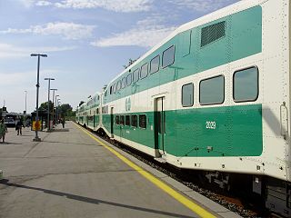
Barrie is one of the seven train lines of the GO Transit system in the Greater Toronto Area, Ontario, Canada. It extends from Union Station in Toronto in a generally northward direction to Barrie, and includes ten stations along its 101.4 kilometres (63.0 mi) route. From 1982 to 1990 and again from 1993 to 2007, it was known as the Bradford line, named after its former terminus at Bradford Station until the opening of Barrie South Station.

York—Simcoe is a federal electoral district in Ontario, Canada, that has been represented in the House of Commons of Canada from 1968 to 1979, from 1988 to 1997 and since 2004.

Buttonville is a suburban planned neighbourhood from a former Police village in the city of Markham, Ontario, Canada, west of the larger Unionville neighbourhood. It is a former hamlet and Police village, named after its founder, John Button. About 30,000 residents live in the area. It is located along the Woodbine Avenue corridor from approximately Highway 7 in the south to Sixteenth Avenue in the north. The Rouge River is in the northeast and Buttonville Airport and Highway 404 are in the west, with three interchanges. The residential area is located in the eastern, northeastern and the northern section while the industrial area is situated to the west and south down to Highway 7. The area is home to many technology companies near the airport. There is talk about renaming the community, the John Button Community after its founder since there has been confusion between Unionville and Buttonville, which is popularly considered to be part of Unionville.

The Bradford Bypass is a proposed east-west highway that would pass north of the town of Bradford, Ontario, Canada. The route would serve as a connector between Highway 400 and Highway 404 on the northern edge of the Greater Toronto Area, in York Region and Simcoe County. The planned western terminus would be Highway 400 near Bradford. The planned eastern terminus would be Highway 404 near Queensville.
King's Highway 88, commonly referred to as Highway 88, was a provincially maintained highway in the Canadian province of Ontario located in the town of Bradford West Gwillimbury, which connected former Highway 27 in the village of Bond Head with former Highway 11 in the town of Bradford. It was established in 1938 and decommissioned in 1998, and has since been known as Simcoe County Road 88.
Victoria Square is an unincorporated community in Markham, Ontario, Canada. The community was formed in the early nineteenth century.

Armadale is a neighbourhood that overlaps into the city of Markham and the former city of Scarborough in Toronto, Ontario, Canada. The historical community is situated in the south-east of Markham and north-east of Scarborough.
Dickson Hill is a small community in northeast Markham, Ontario, Canada, located near Highway 48 and 19th Avenue, on the border to Whitchurch-Stouffville.
Hagerman's Corners is an unincorporated community in Markham, Ontario, Canada. Located at 14th Avenue and Kennedy Road, the former farm lands have disappeared and given way to homes and commercial parks. It is geographically located between the communities of Milliken Mills and Unionville, within the city of Markham.
Wesley Corners is a community situated in the Town of Whitchurch–Stouffville, Ontario, Canada.

Locust Hill is a historic community of Markham, Ontario centred on Hwy. 7 and the Canadian Pacific Railway and within the boundaries of the future national Rouge Park.

Dollar is a former community of Markham Township, now the city of Markham and town of Richmond Hill, Ontario, Canada and was located near the corner of Leslie Street and 15th Avenue. In 1869, Dollar was granted a post office, which was located on the north-west corner of Line 3 and 15th Avenue. In 1871 Dollar also had general store, a blacksmith shop and a church. The Zion Wesleyan Methodist Church was built about 1870 on Lot 10, Concession 3, on the east side of Line 3, just south of the intersection.
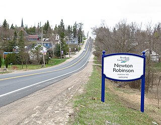
Newton Robinson is located in the southern part of Ontario, Canada, at the tenth concession of Techumseth and Bradford West Gwillimbury. It is approximately an hour's drive from Toronto.


