
The Wyandot people are an Indigenous peoples of the Northeastern Woodlands of the present-day United States and Canada. Their Wyandot language belongs to the Iroquoian language family.

Barrie is a city in Central Ontario, Canada, about 90 kilometres (56 mi) north of Toronto. The city is within Simcoe County and located along the shores of Kempenfelt Bay. Although it is physically in the county, Barrie is politically independent. The city is part of the extended urban area in southern Ontario known as the Greater Golden Horseshoe. As of the 2021 census, the city's population was 147,829, while the census metropolitan area had a population of 212,667 residents.
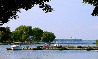
Orillia is a city in Ontario, Canada, about 30 km north-east of Barrie in Simcoe County. It is located at the confluence of Lake Couchiching and Lake Simcoe. Although it is geographically located within Simcoe County, the city is a single-tier municipality. It is part of the Huronia region of Central Ontario. The population in 2021 was 33,411.
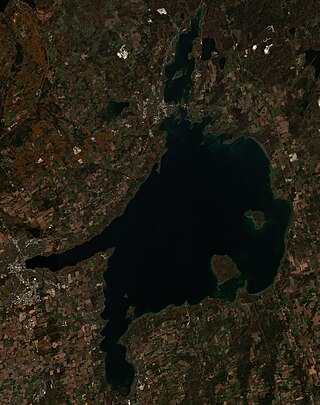
Lake Simcoe is a lake in southern Ontario, Canada, the fourth-largest lake wholly in the province, after Lake Nipigon, Lac Seul, and Lake Nipissing. At the time of the first European contact in the 17th century, the lake was called Ouentironk by the native Wendat/Ouendat (Huron) people. It was also known as Lake Taronto until it was renamed by John Graves Simcoe, the first Lieutenant-Governor of Upper Canada, in memory of his father, Captain John Simcoe of the Royal Navy. In Anishinaabemowin, the historical language of the First Nations living around this lake, namely Anishinaabek of Rama and Georgina Island First Nations, the lake is called Zhooniyaang-zaaga'igan, meaning "Silver Lake".

Georgian Bay is a large bay of Lake Huron, in the Laurentia bioregion. It is located entirely within the borders of Ontario, Canada. The main body of the bay lies east of the Bruce Peninsula and Manitoulin Island. To its northwest is the North Channel.

Midland is a town located on Georgian Bay in Simcoe County, Ontario, Canada. It is part of the Huronia/Wendat region of Central Ontario.

Elmira is the largest community in the township of Woolwich, Ontario, Canada. It is 15 kilometres (9 mi) north of the city of Waterloo near the Regional Municipality of Waterloo's northern border with Wellington County. The community was listed in the 2016 Canadian census as having a population of 10,161.

The 1985 United States–Canada tornado outbreak, referred to as the Barrie tornado outbreak in Canada, was a major tornado outbreak that occurred in Ohio, Pennsylvania, New York, and Ontario, on May 31, 1985. In all 44 tornadoes were counted including 14 in Ontario, Canada. It is the largest and most intense tornado outbreak ever to hit this region, and the worst tornado outbreak in Pennsylvania history in terms of deaths and destruction.

Simcoe County is a county located in the central region of Ontario, Canada. The county is located north of the Greater Toronto Area, and forms the north western edge of the Golden Horseshoe. The largest city in the county is Barrie, while the county seat is located in Midhurst.

Southern Ontario is a primary region of the Canadian province of Ontario. It is the most densely populated and southernmost region in Canada, with approximately 13.5 million people, approximately 36% of Canada's population of 37 million. The region lies south of the province's other primary region, Northern Ontario, although the exact northern boundary of Southern Ontario is disputed. However, its core region is situated south of Algonquin Park, the latter being in an area of transition between coniferous forest north of the French and Mattawa Rivers and southern deciduous forest. It covers between 14 and 15% of the province, depending on the inclusion of the Parry Sound and Muskoka districts which also lie in the transitional area between northern and southern forest regions. Southern Ontario differs greatly from Northern Ontario, having a much higher population density, a different climate, and a different culture than its northern counterpart. It is broken into smaller subregions, including Central Ontario, Eastern Ontario, the Golden Horseshoe, and Southwestern Ontario.
Springwater is a township in central Ontario, Canada, in Simcoe County, near Barrie. It is the county seat of Simcoe County.

Clearview is a rural incorporated township in Simcoe County in Central Ontario, Canada, west of Barrie and south of Collingwood and Wasaga Beach in Simcoe County.

Tiny, also known as Tiny Township, is a township in Simcoe County, south-central Ontario, Canada. The Township of Tiny can be found in the southern Georgian Bay region and is approximately 30 kilometres (19 mi) long or 410 square kilometres (160 sq mi).

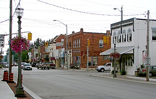
Goderich is a town in the Canadian province of Ontario and is the county seat of Huron County. The town was founded by John Galt and William "Tiger" Dunlop of the Canada Company in 1827. First laid out in 1828, the town is named after Frederick John Robinson, 1st Viscount Goderich, who was prime minister of the United Kingdom at the time. It was incorporated as a town in 1850.
St. Joseph Island is in the northwestern part of Lake Huron. It is part of the Canadian province of Ontario. At 365 km2 (141 sq mi) in area, it is the sixth largest lake island in the world; the second largest island on Lake Huron, following Manitoulin Island; and the third largest of all the islands on the Great Lakes, trailing Manitoulin and Lake Superior's Isle Royale.
On the evening of Tuesday, August 7, 1979, at least three tornadoes touched down in southwestern Ontario, devastating scores of farms and homes in the Woodstock area. The southern end of that city suffered some of the most intense destruction along with several other nearby towns in Oxford County. Two people died, 142 were injured, and hundreds of homes suffered significant damage. Overall monetary losses totaled an approximate $100 million in 1979 Canadian dollars.

Allandale Waterfront GO Station is a train and bus station serving as the northern terminus of GO Transit's Barrie line. The station was built just south of Allandale Station, a historic train station that occupies a large property on the southern shore of Lake Simcoe in the waterfront area of Barrie, Ontario, Canada. The current station and former station were built on a burial site of the Huron indigenous peoples.
The Southern Ontario Tornado Outbreak of 2009 was a series of severe thunderstorms that spawned numerous tornadoes in Southwestern Ontario, Central Ontario and the Greater Toronto Area (GTA) on August 20, 2009, and was the largest single-day tornado outbreak in Ontario history and the largest in Canadian history. During the afternoon and evening, 19 tornadoes touched down with four of them producing F2 damage. One F2 struck the town of Durham where significant damage occurred and one person was killed; two F2s struck the city of Vaughan, just north of Toronto, damaging hundreds of homes; another F2 devastated apple orchards and resort areas near Thornbury. The number of tornadoes associated with this event surpasses that of August 2, 2006, which saw 18 documented tornadoes. In addition, it was one of the most destructive and costly tornado events ever in the province, and included one fatality, one of only a handful of deadly tornadoes in Ontario's recent memory. At one point, over 10 million people in Southern Ontario, one-third of Canada's population, were placed under tornado watches and/or warnings as the storms rolled through.
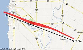
The 2011 Goderich, Ontario tornado was an F3 tornado generated by an isolated supercell which unexpectedly tore across Huron County, Ontario, Canada on the afternoon of Sunday, August 21, 2011. Beginning as a tornadic waterspout over Lake Huron, the tornado ripped through the lakeside town of Goderich severely damaging the historic downtown and homes in the surrounding area. One person died and 37 more were injured as a result. This was the strongest tornado to hit Ontario in over fifteen years, since the April 20, 1996, tornado outbreak in Williamsford, Arthur, and Violet Hill.

Huronia is a historical region in the province of Ontario, Canada. It is positioned between lakes Simcoe, Ontario, and Huron. Similarly to the latter, it takes its name from the Wendat or Huron, an Iroquoian-speaking people, who lived there from prehistoric times until 1649 during the Beaver Wars when they were defeated and displaced by the Five Nations of the Iroquois who lived in New York.


