
Kent County is located in east-central New Brunswick, Canada. The county features a unique blend of cultures including Mi'kmaq, Acadian and English Speaking Settlers. Some larger tourist attractions include la dune de Bouctouche, Kouchibouguac National Park, and Bonar Law Commons.

Northumberland County is located in northeastern New Brunswick, Canada.

Victoria County is located in northwestern New Brunswick, Canada. Farming, especially of potatoes, is the major industry in the county.

Westmorland County is a county in New Brunswick, a province of Canada. It is in the south-eastern part of the province. It contains the fast-growing commercial centre of Moncton and its northern and eastern suburbs. Also located in the county are the university town of Sackville and the tourist destination of Shediac.

York County is located in west-central New Brunswick, Canada. The county contains the provincial capital, Fredericton. Outside the city, farming and forestry are two major industries in the county, which is bisected by the Saint John River. The Southwest Miramichi River flows through the northern section of the county.
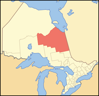
Cochrane District is a district and census division in Northeastern Ontario in the Canadian province of Ontario. It was created in 1921 from parts of Timiskaming and Thunder Bay districts.

Lambton County is a county in Southwestern Ontario, Canada. It is bordered on the north by Lake Huron, which is drained by the St. Clair River, the county's western border and part of the Canada-United States border. To the south is Lake Saint Clair and Chatham-Kent. Lambton County's northeastern border follows the Ausable River and Parkhill Creek north until it reaches Lake Huron at the beach community of Grand Bend. The county seat is in the Town of Plympton-Wyoming.

Thunder Bay District is a district and census division in Northwestern Ontario in the Canadian province of Ontario. The district seat is Thunder Bay.

The Capital Regional District (CRD) is a local government administrative district encompassing the southern tip of Vancouver Island and the southern Gulf Islands in the Canadian province of British Columbia. The CRD is one of several regional districts in British Columbia and had an official population of 383,360 as of the Canada 2016 Census.

Munsee-Delaware Nation is a Lenape First Nations band government located 24 kilometres (15 mi) west of St. Thomas, in southwest Ontario, Canada. Known previously as the Munsee of the Thames, their land base is the 1,054 hectares Munsee-Delaware Nation 1 reserve, with the unincorporated community of Muncey as their main community. The reserve is splintered into several non-contiguous areas, made up of individual lots within the Chippewas of the Thames reserve. As of January 2014, their registered population was 612 people, though only 148 lived on their own reserve.

The Township of Alnwick/Haldimand is a township in central Ontario, Canada, in Northumberland County, situated between Lake Ontario and Rice Lake. It was formed in 2001 by the merger of Alnwick Township in the north and Haldimand Township in the south. Alderville First Nation is an autonomously governed First Nation contained within the township boundaries, in two non-contiguous sections along County Roads 45 and 18.

Zhiibaahaasing First Nation is a First Nation band government in the Canadian province of Ontario. It is a member of the United Chiefs and Councils of Manitoulin.

Webequie First Nation is located on the northern peninsula of Eastwood Island on Winisk Lake, 540 km (336 mi) north of Thunder Bay in Ontario, Canada. Webequie is a fly-in community with no summer road access. The primary way into the community is by air to Webequie Airport or winter road, which connects to the Northern Ontario Resource Trail. The First Nation have the 34,279 ha Webequie Indian Reserve. The Webequie or Webiqui Indian Settlement also have reserve status. Webequie First Nation is a member of the Matawa First Nations, a Regional Chiefs' Council and a member of the Nishnawbe Aski Nation.

Lake of the Woods is a township in the Canadian province of Ontario, located within the Rainy River District. The township is located on the eponymous Lake of the Woods, consisting of mainland in the south-east part of the lake, the southern shores of Aulneau Peninsula, along with several islands in the lake, including Big Island and Bigsby Island. It fully surrounds the Anishnaabeg of Naongashiing, Big Grassy River 35G, Big Island Mainland 93, and Saug-a-Gaw-Sing 1 First Nation reserves.

Christian Island 30 is a First Nations reserve located on Christian Island in Georgian Bay, in Ontario. It is one of the reserves of the Beausoleil First Nation.
Beausoleil First Nation is an Ojibwe First Nation band government located in Simcoe County, Ontario, Canada. The main settlement of the Beausoleil First Nation is on Christian Island, Ontario, Canada in southern Georgian Bay. As of 2018, the total number of status Indians registered with the First Nation is 2,587. The on-reserve population is 614.

The Hiawatha First Nation is a Mississauga Ojibwe First Nations reserve located on the north shore of Rice Lake east of the Otonabee River in Ontario, Canada.
Hatchet Lake Denesuline Nation is a Denesuline First Nation in northern Saskatchewan. The main settlement, Wollaston Lake, is an unincorporated community on Wollaston Lake in the boreal forest of north-eastern Saskatchewan, Canada.

Montreal Lake Cree Nation is a Woodland Cree First Nation in the boreal forest of central Saskatchewan, Canada. Its reserve, Montreal Lake 106, is on the southern shore of Montreal Lake 103 km (64 miles) north of Prince Albert and 167 km (104 miles) south of La Ronge. Highway 969 passes through the village.
