Edenvale, Ontario

Last updated

Edenvale
Unincorporated rural community
Canada location map 2.svg
Red pog.svg
Edenvale
Canada Ontario location map 2.svg
Red pog.svg
Edenvale
Coordinates: 44°27′03″N79°54′07″W / 44.45083°N 79.90194°W / 44.45083; -79.90194
CountryCanada
Province Ontario
County Simcoe
Township Springwater
Time zone UTC-5 (Eastern (EST))
  Summer (DST) UTC-4 (EDT)
GNBC CodeFBBQU [1]

Edenvale is an unincorporated place in Springwater Township, Simcoe County, Ontario, Canada. [1] [2]

Contents

It is located on Ontario Highway 26. The Nottawasaga River flows through Edenvale.

Little remains today of the once a thriving pioneer settlement.

Early history

Stone cairn marking the location of the Glengarry Landing National Historic Site Glengarry Landing Stone Cairn Ontario Canada.jpg
Stone cairn marking the location of the Glengarry Landing National Historic Site

The village was named by pioneer settler John Culham, who described the surrounding countryside as the Garden of Eden. Other names from the early days of Edenvale include Giffen, McNabb, Walker, Campbell, Thompson, Richardson and Robertson.

Although Edenvale was not settled until 1867, a contingent of soldiers led by Lieutenant Colonel Robert McDouall spent a winter encamped at what was then called Glengarry Landing during the War of 1812. The approximate site on the west bank of the Nottawasaga River and along the northside of Ontario Highway 26 was marked by cairn and marker in 1923. [3] The soldiers were making the arduous journey from Kingston to the British post on Michilimackinac Island. [4]

The first permanent inhabitants of Edenvale in 1867 were the Coughlin, Lavery and Nicholson families. At the time, Edenvale extended south to the Minesing Swamp, west to the Vespra-Sunnidale Town line, north to Concession 2 of Flos Township and east to Concession 11 of Vespra Township. Edenvale had very fertile soil, producing wheat, grain, clover seeds and peas, as well as supporting livestock and a flourishing lumber industry.

Late 19th century village

In 1876, a fire destroyed a significant part of Edenvale and many homes constructed after that time were built with lumber that had noticeable burn scars on them.

Several lumber mills sprung up in Edenvale. The Keeley family established Keeley's Mill in 1881 on the Nottawasaga River north of the Vespra-Flos Townline. The Methodist church in the village was built with lumber milled and donated by the Keeley family. The mill burned down in 1888.

In 1886, John Pilkey opened a shingle mill in Edenvale. Two years later, a sawmill was also opened east of Sideroad 25-26. The mill burned to the ground three times between 1890 and 1929 and was not rebuilt after the last fire. Carter's Mill was opened by the Carter Brothers in 1895. Situated on the south side of the Edenvale bridge over the Nottawasaga River, it operated until 1906. Other industries and businesses included Lovering's Mill (a winter operation only), Tallman's Cheese Factory, Bennett's Creamery, Graham Blacksmith Shop and Campbell Slaughterhouse.

The first store was opened by Fred and Frank Mercer in 1881. The Edenvale post office opened in 1908, with Stephen Elliott as the first Postmaster. Elliott also operated the General Store and the telephone exchange. Prior to the opening of the post office, residents had to go to Sunnidale Corners or Stayner for postal services.

Village schools

Edenvale had two schools: SS #10 East, opened in 1883 on Concession 12 in Vespra Township and SS #10 West, opening in 1895 on Concession 14 in Vespra Township. SS #10 East closed in January 1949 as there were only two students. The school re-opened in 1953 with 12 students. SS #10 West closed around the same time and all students attended #10 East until it closed again in 1960. SS #10 East remains in its original location and is now a private residence. SS #10 West was demolished many years ago. Some of the expenses from the school's 1883-1895 logbook were $0.15 for a fool's cap; $5.50 for a school bell; $1.00 for the stove; $67.50 for seats; $7.00 for the teacher's desk.

Village churches

Edenvale also had two churches: the Methodist Church, built in 1881 and the Presbyterian, built across the road from the Methodist in 1900. The Presbyterian church, officially named the Century Presbyterian Church of Edenvale, closed in 1966 and was demolished in 1976. A miniature replica of the church sits on a post in front of the former church property.

The Methodist Church closed in 1918. From 1921 to 1941, the former church was used by the United Farmers Union as a union hall. It then became the Edenvale Community Centre. Extensive renovations were done on the building using wood from the former SS #9 schoolhouse in Flos Township. The building was closed and demolished in 1998. The property is now Edenvale Park, a small passive park featuring two wooden benches and a plaque commemorating the Methodist Church of Edenvale.

Civic history

An Edenvale Women's Institute was founded in 1908 by Miss Susie Campbell. In 1938, Edenvale hosted the first International Plowing Match to be held in Simcoe County, with a then record 132,000 in attendance. In 1940, the Royal Canadian Air Force built an airfield nearby. Although it was just across the Flos / Sunnidale Townline in Sunnidale Township, it was named RCAF Detachment Edenvale. Hydroelectricity came to Edenvale in 1946. The Edenvale 4-H Club was founded in 1950.

Today

Little remains of the once vibrant community. For many years, the most prominent feature of the former village was the Edenvale Garage & Motor Sales on Highway 26, at the centre of the former village, but this has since closed.

Several active farms also remain, along with the aforementioned SS #10 East schoolhouse, and the Strongville Gospel Church, a congregation that has existed for 100 years. The church remains in the same location on Strongville Road, but not in its original building. That building was moved just north to the intersection of Strongville Road and Sunnidale Concession Road 9, and now makes up part of a private residence. That private residence is also home to the first & original post office where the back portion of the building still stands today.

A cairn commemorating the Glengarry Landing stands at the entrance to the Edenvale Conservation Area, run by the Nottawasaga Valley Conservation Authority.

Related Research Articles

<span class="mw-page-title-main">King, Ontario</span> Township in Ontario, Canada

King is a township in York Region north of Toronto, within the Greater Toronto Area in Ontario, Canada.

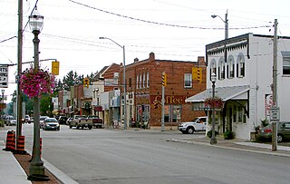
Alliston is a settlement in Simcoe County in the Canadian province of Ontario. It has been part of the Town of New Tecumseth since the 1991 amalgamation of Alliston and nearby villages of Beeton, Tottenham, and the Township of Tecumseth. The primary downtown area is located along Highway 89, known as Victoria Street.

<span class="mw-page-title-main">Simcoe County</span> County in Ontario, Canada

Simcoe County is located in the central portion of Southern Ontario, Canada. The county is just north of the Greater Toronto Area, stretching from the shores of Lake Simcoe in the east to Georgian Bay in the west. Simcoe County forms part of the Greater Golden Horseshoe area, a densely populated and industrialized region, centred on the Greater Toronto Area.

<span class="mw-page-title-main">Wasaga Beach</span> Town in Ontario, Canada

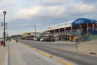
Wasaga Beach is a town in Simcoe County, Ontario, Canada. Situated along the longest freshwater beach in the world, it is a popular summer tourist destination. It is located along the southern end of Georgian Bay, approximately 150 km (93 mi) north of Toronto and about 40 km (25 mi) northwest of Barrie. To the west, Collingwood and The Blue Mountains also attract visitors much of the year. The town is situated along a very long sandy beach on Nottawasaga Bay in Georgian Bay and the winding Nottawasaga River. The beaches are part of the Wasaga Beach Provincial Park; the park area totals 168 hectares. Wasaga Beach has a year-round population of 24,862 as of 2021, but during the summer months the population increases with many seasonal residents.

<span class="mw-page-title-main">Springwater, Ontario</span> Township in Ontario, Canada

Springwater is a township in central Ontario, Canada, in Simcoe County, near Barrie. It is the county seat of Simcoe County.

<span class="mw-page-title-main">Clearview, Ontario</span> Township in Ontario, Canada

Clearview is a rural incorporated township in Simcoe County in Central Ontario, Canada, west of Barrie and south of Collingwood and Wasaga Beach in Simcoe County.

<span class="mw-page-title-main">Simcoe North (federal electoral district)</span> Federal electoral district in Ontario, Canada

Simcoe North is a federal electoral district in central Ontario, Canada. It was established as a federal riding in 1867.

<span class="mw-page-title-main">Simcoe—Grey (federal electoral district)</span> Federal electoral district in Ontario, Canada

Simcoe—Grey is a federal electoral district in Ontario, Canada, that has been represented in the House of Commons of Canada since 1997.

<span class="mw-page-title-main">Edwardsburgh/Cardinal</span> Township in Ontario, Canada

Edwardsburgh/Cardinal is a township in the United Counties of Leeds and Grenville of eastern Ontario, Canada. Edwardsburgh township was first surveyed in 1783, and incorporated in 1850. The township was part of the historical Grenville County before it merged with Leeds County to form the United Counties in the 19th century.

<span class="mw-page-title-main">Augusta, Ontario</span> Township in Ontario, Canada

Augusta Township is a township in the United Counties of Leeds and Grenville, located in eastern Ontario, Canada. Augusta is situated along the Saint Lawrence River, and extends back into rural hamlets. The township is located between the city of Brockville to the west, and the town of Prescott to the east.

<span class="mw-page-title-main">Blandford-Blenheim</span> Township in Ontario, Canada

Blandford-Blenheim is a township in the Canadian province of Ontario, located in Oxford County. The township had a population of 7,359 in the Canada 2011 Census.

<span class="mw-page-title-main">Walsh, Ontario</span> Community of Norfolk County, Ontario, Canada

Walsh is a medium-sized hamlet in Norfolk County, Ontario, Canada.

<span class="mw-page-title-main">Chesterville, Ontario</span> Village in Ontario, Canada

Chesterville is a village in the township of North Dundas, within the United Counties of Stormont, Dundas and Glengarry. It is located north of Morrisburg, west of Cornwall and south-east of Ottawa. The village is situated along the South Nation River.

Lancaster is an unincorporated community in Lancaster Township, Jefferson County, Indiana.

<span class="mw-page-title-main">Banda, Ontario</span> Unincorporated rural community in Ontario, Canada

Banda is an unincorporated rural community in Dufferin County, Ontario, Canada.

<span class="mw-page-title-main">Locust Hill, Ontario</span> Unincorporated community and former hamlet in Ontario, Canada

Locust Hill is a historic community of Markham, Ontario centred on Hwy. 7 and the Canadian Pacific Railway and within the boundaries of the future national Rouge Park.

Mongolia is an historical community in Markham, Ontario centred on 10th Line and Elgin Mills Rd. East, immediately south of the Town of Whitchurch-Stouffville. The hamlet lies completely within the expropriated federal Pickering Airport lands and also within the proposed boundaries of a future national Rouge Park.

Walton is a Southwestern Ontario hamlet in Huron County, Ontario, Canada, located at the intersection of Huron County Road 12 and Road 25, 45 km east of Goderich.

King's Highway 92, also known as Highway 92, was a provincially maintained highway in the Canadian province of Ontario. The route connected Highway 26 west of Wasaga Beach with Highway 27 in Elmvale. Highway 92 was established in 1936, although it did not extend through Wasaga Beach to Highway 26 until the early 1980s. The entire route was downloaded in 1997 and transferred to Simcoe County. Today, the section of the former highway outside Wasaga Beach is known as Simcoe County Road 92.

Sunshine is a dispersed rural community in the municipality of Morris-Turnberry, Huron County, Ontario, Canada.

References

  1. 1 2 "Edenvale". Natural Resources Canada. October 6, 2016.
  2. "Springwater". Statistics Canada. November 2, 2016.
  3. https://www.pc.gc.ca/apps/dfhd/page_nhs_eng.aspx?id=368
  4. Collins, Gilbert (2006). Guidebook to the Historic Sites of the War of 1812: 2nd Edition. Dundurn Press. ISBN   1-55002-626-7.