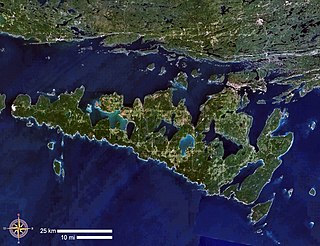
Manitoulin Island is an island in Lake Huron, located within the borders of the Canadian province of Ontario, in the bioregion known as Laurentia. With an area of 2,766 km2 (1,068 sq mi), it is the largest lake island in the world, large enough that it has over 100 lakes itself. In addition to the historic Anishinaabe and European settlement of the island, archaeological discoveries at Sheguiandah have demonstrated Paleo-Indian and Archaic cultures dating from 10,000 BC to 2,000 BC.
Nickel Belt is one of two federal electoral districts serving the city of Greater Sudbury, Ontario, Canada. It has been represented in the House of Commons of Canada since 1953.

Northeastern Manitoulin and the Islands is a municipality with town status in Manitoulin District in Northeastern Ontario, Canada, approximately 30 kilometres (19 mi) south of Espanola. Its main town is Little Current, located on the northeast side of Manitoulin Island. However, its territory also includes most of the small islands surrounding Manitoulin, even those at the far western end of Manitoulin.

Manitoulin District is a district in Northeastern Ontario within the Canadian province of Ontario. It was created in 1888 from part of the Algoma District. The district seat is in Gore Bay.
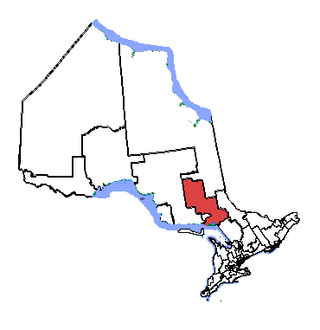
Algoma—Manitoulin—Kapuskasing is a federal electoral district in Ontario, Canada, that has been represented in the House of Commons of Canada since 2004. The area was represented by the riding of Algoma from 1867 to 1904 and from 1968 to 1996 and then by Algoma—Manitoulin from 1996 to 2004.

The Wiikwemkoong First Nation is a First Nation on Manitoulin Island in Northern Ontario. The Wiikwemkoong Unceded Territory is the First Nation reserve in the northeast of Manitoulin Island in Manitoulin District, Ontario, Canada. Wiikwemkoong is an unceded Indigenous reserve in Canada, which means that it has not "relinquished title to its land to the government by treaty or otherwise."

The Township of Alnwick/Haldimand is a township in central Ontario, Canada, in Northumberland County, situated between Lake Ontario and Rice Lake. It was formed in 2001 by the merger of Alnwick Township in the north and Haldimand Township in the south. Alderville First Nation is an autonomously governed First Nation contained within the township boundaries, in two non-contiguous sections along County Roads 45 and 18.

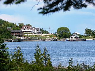
Assiginack is a township in the Canadian province of Ontario, located on Manitoulin Island. An Ontario Historical Plaque was built on the grounds of the Assiginack Museum by the province to commemorate the Manitoulin Treaties' role in Ontario's heritage.

Baldwin is a township in the Canadian province of Ontario. Located in Sudbury District north of Espanola, the township's two main communities and population centres are McKerrow and Lorne.

Cockburn Island is an island and township municipality in the Canadian province of Ontario, located in the Manitoulin District. It is separated from the westernmost point of Manitoulin Island by the Mississagi Strait, and from Michigan's Drummond Island by the False Detour Channel. The island is incorporated as and coterminous with the municipal Township of Cockburn Island.

The Mississagi Strait is a narrow strait or channel in Manitoulin District, Ontario, Canada, located in Lake Huron. It connects the North Channel to the main water body, and also separates Manitoulin Island to the east from Cockburn Island to the west.

M'Chigeeng First Nation, also known as West Bay, is an Ojibwe First Nation band government in the Manitoulin District of Ontario, Canada. The total registered population as of December 2018, was 2623 people, of which their on-reserve population was 939. The First Nation have reserved for themselves the 3094.7 ha M'Chigeeng 22 Indian Reserve located on Manitoulin Island.

Rankin Location 15D is one of four reserves of the Batchewana First Nation of Ojibways in Algoma District in northeastern Ontario, Canada. It is bounded on the north, west and south by the city of Sault Ste. Marie, and on the east by Garden River First Nations reserve of another Ojibwe people. As of 2005, a total of 2,205 people were registered to the Nation; about half live on the reserves and many others live in Sault Ste. Marie.

Bearskin Lake First Nation is an Oji-Cree First Nation reserve in Kenora District, Ontario, Canada, located 425 kilometres (264 mi) north of Sioux Lookout. Bearskin First Nation's total registered population as of March 2014 was 900, of which their on-reserve population was 461.

Apitipi Anicinapek Nation, formerly known as Wahgoshig First Nation, is an Algonquin Anicinape community, located near Matheson in Cochrane District in northeastern Ontario, Canada. In January 2008, the First Nation had 270 people registered with the nation, of which their on-reserve population was 121.
Sachigo Lake First Nation is an Oji-Cree First Nation band government in Unorganized Kenora District in Northwestern Ontario, Canada. It is located on Sachigo Lake, part of the Sachigo River system and Hudson Bay drainage basin, approximately 425 kilometres (264 mi) north of the town of Sioux Lookout. As of September 2011, the First Nation had a registered population of 814 people, of which the on-reserve population was 443.
Unorganized West Part Manitoulin District is an unorganized area in Manitoulin District in northeastern Ontario, Canada, encompassing the portion of Manitoulin Island which is not part of an organized municipality. It comprises the geographic townships of Robinson and Dawson.
Goulais Bay 15A is a First Nations reserve in Algoma District, Ontario, Canada. It lies on Goulais Bay, encompassing most of the unincorporated community of Goulais Mission, and is one of the reserves of the Batchewana First Nation of Ojibways.
Whitefish River First Nation is an Ojibwe First Nation in Manitoulin District, Ontario. It is a member of the United Chiefs and Councils of Manitoulin. Its reserve is located at Whitefish River 4.

