Tehkummah

Last updated
Tehkummah
Township of Tehkummah
M.S. Chi-Cheemaun ferry at South Baymouth.jpg
The MS Chi-Cheemaun docking in South Baymouth
Manitoulin locator map 2021.svg
Red pog.svg
Tehkummah
Canada Ontario location map 2.svg
Red pog.svg
Tehkummah
Coordinates: 45°39′N81°59′W / 45.65°N 81.98°W / 45.65; -81.98 Coordinates: 45°39′N81°59′W / 45.65°N 81.98°W / 45.65; -81.98
Country Canada
Province Ontario
District Manitoulin
Incorporated1881
Government
  TypeTownship
  ReeveDavid Jaggard
   MP Carol Hughes (NDP)
   MPP Michael Mantha (NDP)
Area
[1]
  Land132.69 km2 (51.23 sq mi)
Population
 (2016) [1]
  Total436
  Density3.3/km2 (9/sq mi)
Time zone UTC-5 (EST)
  Summer (DST) UTC-4 (EDT)
Postal code
P0P 2C0
Area code(s) 705, 249

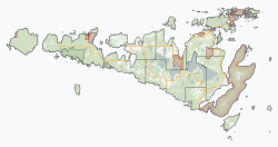
Tehkummah is a township in the Canadian province of Ontario, located on Manitoulin Island.
Contents

Communities

South Bay is frozen over at the center. North is oriented towards the upper left in this photo taken from the International Space Station on April 10, 2022. Southeastern tip of Manitoulin Island, cropped from ISS067-E-7704.jpg
South Bay is frozen over at the center. North is oriented towards the upper left in this photo taken from the International Space Station on April 10, 2022.

The best known community in the township is South Baymouth, the northern docking point of the MS Chi-Cheemaun passenger-car ferry which traverses the Main Channel of Georgian Bay from the community of Tobermory on the Bruce Peninsula. At the dock, the provincial Highway 6, whose southern segment ends at Tobermory, resumes and continues northward to its terminus at Highway 17 north of Espanola.

The administrative centre of the township is the community of Tehkummah.

The township also includes the ghost towns of Michael's Bay and Snowville.

Demographics

In the 2021 Census of Population conducted by Statistics Canada, Tehkummah had a population of 450 living in 224 of its 368 total private dwellings, a change of 3.2% from its 2016 population of 436. With a land area of 131.7 km2 (50.8 sq mi), it had a population density of 3.4/km2 (8.8/sq mi) in 2021. [2]

Canada census – Tehkummah community profile
2016 2011
Population436 (+7.4% from 2011)406 (+6.3% from 2006)
Land area132.48 km2 (51.15 sq mi)132.48 km2 (51.15 sq mi)
Population density3.3/km2 (8.5/sq mi)3.1/km2 (8.0/sq mi)
Median age59.0 (M: 58.9, F: 59.2)
Total private dwellings333353
Median household income$50,432
References: 2016 [3] 2011 [4] earlier [5] [6]

Climate

Climate data for South Baymouth (1981−2010)
MonthJanFebMarAprMayJunJulAugSepOctNovDecYear
Record high °C (°F)7.8
(46.0)
8.0
(46.4)
15.0
(59.0)
24.5
(76.1)
29.5
(85.1)
30.0
(86.0)
33.9
(93.0)
32.5
(90.5)
28.3
(82.9)
23.9
(75.0)
17.2
(63.0)
14.0
(57.2)
33.9
(93.0)
Average high °C (°F)−3.2
(26.2)
−2.4
(27.7)
1.5
(34.7)
8.2
(46.8)
14.6
(58.3)
19.3
(66.7)
23.3
(73.9)
22.5
(72.5)
17.4
(63.3)
11.3
(52.3)
5.3
(41.5)
−0.4
(31.3)
9.8
(49.6)
Daily mean °C (°F)−7.9
(17.8)
−7.2
(19.0)
−3.3
(26.1)
3.8
(38.8)
9.7
(49.5)
14.2
(57.6)
18.2
(64.8)
17.9
(64.2)
13.5
(56.3)
7.7
(45.9)
2.1
(35.8)
−4.2
(24.4)
5.4
(41.7)
Average low °C (°F)−12.5
(9.5)
−12
(10)
−8
(18)
−0.7
(30.7)
4.8
(40.6)
9.0
(48.2)
13.1
(55.6)
13.3
(55.9)
9.5
(49.1)
4.0
(39.2)
−1
(30)
−7.9
(17.8)
1.0
(33.8)
Record low °C (°F)−37
(−35)
−36.5
(−33.7)
−31.1
(−24.0)
−19.5
(−3.1)
−4.4
(24.1)
0.0
(32.0)
4.4
(39.9)
−0.6
(30.9)
−3.5
(25.7)
−8.3
(17.1)
−19
(−2)
−33
(−27)
−37
(−35)
Average precipitation mm (inches)78.1
(3.07)
49.8
(1.96)
63.9
(2.52)
69.2
(2.72)
71.6
(2.82)
58.6
(2.31)
50.9
(2.00)
74.2
(2.92)
95.2
(3.75)
112.0
(4.41)
92.2
(3.63)
94.0
(3.70)
909.6
(35.81)
Average rainfall mm (inches)13.1
(0.52)
6.5
(0.26)
38.0
(1.50)
57.9
(2.28)
71.6
(2.82)
58.6
(2.31)
50.9
(2.00)
74.2
(2.92)
95.2
(3.75)
111.9
(4.41)
73.6
(2.90)
29.6
(1.17)
681.1
(26.81)
Average snowfall cm (inches)65.0
(25.6)
43.3
(17.0)
25.9
(10.2)
11.3
(4.4)
0.0
(0.0)
0.0
(0.0)
0.0
(0.0)
0.0
(0.0)
0.0
(0.0)
0.08
(0.03)
18.5
(7.3)
64.5
(25.4)
228.4
(89.9)
Average precipitation days (≥ 0.2 mm)15.911.210.512.111.210.27.910.612.914.914.117.4148.9
Average rainy days (≥ 0.2 mm)2.71.95.610.211.210.27.910.612.914.910.65.9104.5
Average snowy days (≥ 0.2 cm)13.59.75.62.50.00.00.00.00.00.083.812.848.1
Mean monthly sunshine hours 74.397.5162.8190.8242.9264.6307.1256.2187.8127.970.457.52,039.8
Percent possible sunshine 26.233.444.247.152.656.464.758.649.837.624.621.143.0
Source: Environment Canada [7]

See also

Related Research Articles

North Grenville Municipality in Ontario, Canada

North Grenville is a township in eastern Ontario, Canada, in the United Counties of Leeds and Grenville on the Rideau River. It is located just south of Ottawa in Canada's National Capital Region.

Manitoulin District District in Ontario, Canada

Manitoulin District is a district in Northeastern Ontario within the Canadian province of Ontario. It was created in 1888 from part of the Algoma District. The district seat is in Gore Bay.

Seguin, Ontario Township in Ontario, Canada

Seguin is a township in central Ontario, Canada, in the District of Parry Sound.

Laird, Ontario Township in Ontario, Canada

Laird is a township and village in the Algoma District in Northern Ontario, Canada. The township had a population of 1,047 in the Canada 2016 Census, down from 1,057 in the 2011 census.

Nipissing, Ontario Township in Ontario, Canada

Nipissing is an incorporated (political) township in Parry Sound District in Central Ontario, Canada. It is on Lake Nipissing and is part of the Almaguin Highlands region. Nipissing was surveyed between 1874 and 1881, and was incorporated in 1888. Among the first settlers in the area were the Chapman and Beatty families. Nipissing Township annexed Gurd Township in 1970. The township also contains a community named Nipissing, which is located on the South River near Chapman's Landing, on the South Bay of Lake Nipissing. The township administrative offices are located in Nipissing.

Gore Bay, Ontario Town in Ontario, Canada

]

St. Joseph, Ontario Township in Ontario, Canada

St. Joseph is a township in the Canadian province of Ontario, the largest of four municipalities on St. Joseph Island. It had a population of 1,240 in the Canada 2016 Census.

Central Manitoulin Township in Ontario, Canada

Central Manitoulin is a township in the Canadian province of Ontario. It is located on Manitoulin Island and in Manitoulin District.

Johnson, Ontario Township in Ontario, Canada

Johnson is a township in the Canadian province of Ontario, located within the Algoma District. The township had a population of 751 in the Canada 2016 Census, up from 750 in the 2011 census.

Assiginack Township in Ontario, Canada

Assiginack is a township in the Canadian province of Ontario, located on Manitoulin Island. An Ontario Historical Plaque was built on the grounds of the Assiginack Museum by the province to commemorate the Manitoulin Treaties' role in Ontario's heritage.

Macdonald, Meredith and Aberdeen Additional Township in Ontario, Canada

Macdonald, Meredith and Aberdeen Additional is a township in Algoma District, Ontario, Canada. Originally surveyed as separate geographical townships, Macdonald and Meredith were incorporated as a single, municipal township in 1892. The geographical township of Aberdeen Additional was added to Macdonald and Meredith township in 1899 to create the municipal township of Macdonald, Meredith and Aberdeen Additional.

Northern Bruce Peninsula Municipality in Ontario, Canada

The Municipality of Northern Bruce Peninsula is located on the Bruce Peninsula in Bruce County, Ontario, Canada. It is a popular vacation spot in the summer for its water sports and cottaging, and in the winter for snowmobiling. The municipality was formed on January 1, 1999, when the townships of St. Edmunds, Lindsay, and Eastnor, as well as the Village of Lion's Head, were amalgamated.

The North Shore, Ontario Township in Ontario, Canada

The North Shore is a township in the Canadian province of Ontario, located in the Algoma District. The township had a population of 497 in the Canada 2016 Census. It is along the north shore of the North Channel of Lake Huron, with its main communities all along Highway 17.

Mattawan, Ontario Municipality in Ontario, Canada

Mattawan is a municipality in the Canadian province of Ontario. Located in the Nipissing District, the municipality had a population of 161 in the Canada 2016 Census.

North Algona Wilberforce Township municipality in Ontario, Canada

North Algona Wilberforce is a township municipality in Renfrew County, Ontario, Canada. It has a population of 2,873. The township was formed in 1999 when the North Algona and Wilberforce townships were amalgamated.

Machin, Ontario Township in Ontario, Canada

Machin is a township in the Canadian province of Ontario, located in the Kenora District west of Dryden.

OConnor, Ontario Township in Ontario, Canada

O'Connor is a township in the Canadian province of Ontario, located 32 kilometres (20 mi) west of the city of Thunder Bay. The municipality was formed on January 1, 1907. The township serves as a bedroom community of Thunder Bay, with some agriculture, and is part of Thunder Bay's Census Metropolitan Area.

Plummer Additional Township in Ontario, Canada

Plummer Additional is a township and single tier municipality located in Algoma District in Northeastern Ontario, Canada. The township had a population of 660 in the Canada 2016 Census.

Tarbutt Township in Ontario, Canada

Tarbutt is a township in the Canadian province of Ontario, located within the Algoma District. The township is about 40 kilometres (25 mi) east of Sault Ste. Marie.

Enniskillen, Ontario Township in Ontario, Canada

Enniskillen is a township in the Canadian province of Ontario, within Lambton County. It is located at the intersection of Highway 21 and Rokeby Line. The economy of the township is based on agriculture. It was named after Sir Galbraith Lowry Cole's father who was the Earl of Enniskillen, Northern Ireland.

References

  1. 1 2 "Tehkummah Census profile". 2016 Census of Population . Statistics Canada. Retrieved 2012-02-22.
  2. "Population and dwelling counts: Canada, provinces and territories, census divisions and census subdivisions (municipalities), Ontario". Statistics Canada. February 9, 2022. Retrieved April 2, 2022.
  3. "2016 Community Profiles". 2016 Canadian Census . Statistics Canada. August 12, 2021. Retrieved 2019-06-20.
  4. "2011 Community Profiles". 2011 Canadian Census . Statistics Canada. March 21, 2019. Retrieved 2012-02-22.
  5. "2006 Community Profiles". 2006 Canadian Census . Statistics Canada. August 20, 2019.
  6. "2001 Community Profiles". 2001 Canadian Census . Statistics Canada. July 18, 2021.
  7. "South Baymouth, Ontario". Canadian Climate Normals 1981–2010. Environment Canada . Retrieved February 16, 2015.