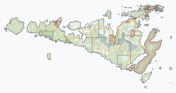
Burpee and Mills

Last updated

Burpee and Mills
Township of Burpee and Mills
Burpee & Mills ON.JPG
Manitoulin locator map 2021.svg
Red pog.svg
Burpee and Mills
Canada Ontario location map 2.svg
Red pog.svg
Burpee and Mills
Coordinates: 45°47′N82°34′W / 45.783°N 82.567°W / 45.783; -82.567
Country Canada
Province Ontario
District Manitoulin
FormedJanuary 1, 1998
Government
  TypeTownship
  ReeveKen Noland
   MP Carol Hughes (NDP)
   MPP Michael Mantha (NDP)
Area
[1]
  Land218.48 km2 (84.36 sq mi)
Population
 (2016) [2]
  Total343
  Density1.6/km2 (4/sq mi)
Time zone UTC-5 (EST)
  Summer (DST) UTC-4 (EDT)
Postal code
P0P 1H0
Area code(s) 705, 249
Website www.burpeemills.com OOjs UI icon edit-ltr-progressive.svg

Burpee and Mills is a township in the Canadian province of Ontario. It was formed on January 1, 1998, through the annexation of the unorganized geographic township of Mills by Burpee Township.

Contents

Located in the Manitoulin District, the township had a population of 343 in the 2016 Canadian census. Industries include tourism, agriculture, aquaculture, and logging.

Communities

The township comprises the communities of Burpee, Elizabeth Bay, Evansville and Poplar.

Rural country between Evansville and Elizabeth Bay Burpee & Mills ON 2.JPG
Rural country between Evansville and Elizabeth Bay

Demographics

In the 2021 Census of Population conducted by Statistics Canada, Burpee and Mills had a population of 382 living in 167 of its 292 total private dwellings, a change of 11.4% from its 2016 population of 343. With a land area of 217.33 km2 (83.91 sq mi), it had a population density of 1.8/km2 (4.6/sq mi) in 2021. [3]

Canada census – Burpee and Mills community profile
2021 2016 2011
Population382 (+11.4% from 2016)343 (+11.4% from 2011)308 (-6.4% from 2006)
Land area217.33 km2 (83.91 sq mi)218.48 km2 (84.36 sq mi)218.48 km2 (84.36 sq mi)
Population density1.8/km2 (4.7/sq mi)1.6/km2 (4.1/sq mi)1.4/km2 (3.6/sq mi)
Median age58.0 (M: 58.0, F: 59.2)54.8 (M: 53.6, F: 55.6)
Private dwellings292 (total)  167 (occupied)274 (total) 255 (total) 
Median household income$61,600$56,192
References: 2021 [4] 2016 [5] 2011 [6] earlier [7] [8]
Historical population
YearPop.±%
2001 362    
2006 329−9.1%
2011 308−6.4%
2016 343+11.4%
[9] [1] [2]

See also

Related Research Articles

<span class="mw-page-title-main">North Grenville</span> Municipality in Ontario, Canada

North Grenville is a township in eastern Ontario, Canada, in the United Counties of Leeds and Grenville on the Rideau River. It is located just south of Ottawa in Canada's National Capital Region.

<span class="mw-page-title-main">Dawn-Euphemia</span> Township in Ontario, Canada

Dawn-Euphemia is a township in southwestern Ontario, Canada, in Lambton County. Residents primarily are employed by the agricultural industry, or by local industries such as Union Gas distribution centre, along with various smaller agricultural manufacturers or service providers. The township municipal office is located in Rutherford.

<span class="mw-page-title-main">Lanark Highlands</span> Township in Ontario, Canada

Lanark Highlands is a township in eastern Ontario, Canada in Lanark County. The township administrative offices are located in the village of Lanark.

<span class="mw-page-title-main">Madoc, Ontario (township)</span> Township in Ontario, Canada

Madoc is a township in Hastings County in Eastern Ontario, Canada.

<span class="mw-page-title-main">Mulmur</span> Township in Ontario, Canada

Mulmur is a township in Dufferin County in Southern Ontario, Canada. There are a number of original settlements such as Mulmur Corners, some of which can still be identified as to location, including Rosemont and Stanton.

<span class="mw-page-title-main">Southwold, Ontario</span> Township in Ontario, Canada

Southwold is a township in Elgin County, in Ontario, Canada, located on the north shore of Lake Erie. It is a rich agricultural zone producing predominantly corn and soybeans. It is part of the London census metropolitan area.

<span class="mw-page-title-main">Laird, Ontario</span> Township in Ontario, Canada

Laird is a township and village in the Algoma District in Northern Ontario, Canada. The township had a population of 1,047 in the Canada 2016 Census, down from 1,057 in the 2011 census.

<span class="mw-page-title-main">Hamilton Township, Ontario</span> Township in Ontario, Canada

Hamilton Township is a rural township located in Northumberland County in central Ontario. It surrounds the Town of Cobourg.

<span class="mw-page-title-main">Red Rock, Ontario</span> Township in Ontario, Canada

Red Rock is a township in Northwestern Ontario, Canada, located in the Thunder Bay District. The community of Red Rock sits on the shore of Lake Superior, about 16 km west of the Nipigon River where it drains into Nipigon Bay on the north shore of Lake Superior. The population as of 2011 is 942.

<span class="mw-page-title-main">Tyendinaga, Ontario</span> Township in Ontario, Canada

Tyendinaga is a township in the Canadian province of Ontario, located in Hastings County. The community takes its name from a variant spelling of Mohawk leader Joseph Brant's traditional Mohawk name, Thayendanegea.

<span class="mw-page-title-main">Whitestone, Ontario</span> Municipality in Ontario, Canada

Whitestone is a municipality in the Canadian province of Ontario, as well as the name of a community within the municipality.

<span class="mw-page-title-main">Carlow/Mayo</span> Township in Ontario, Canada

Carlow Mayo is a township in northern Hastings County in Eastern Ontario, Canada. It was formed in 2001 by the amalgamation of the townships of Carlow and Mayo.

<span class="mw-page-title-main">Billings, Ontario</span> Township in Ontario, Canada

Billings is a township in the Canadian province of Ontario, as well as the name of a community within that township.

<span class="mw-page-title-main">Dawson, Ontario</span> Township in Ontario, Canada

Dawson is a township located in Rainy River District in Northwestern Ontario, Canada. The township is located at the mouth of the Rainy River where it flows into Lake of the Woods.

<span class="mw-page-title-main">The North Shore, Ontario</span> Township in Ontario, Canada

The North Shore is a township in the Canadian province of Ontario, located in the Algoma District. The township had a population of 497 in the Canada 2016 Census. It is along the north shore of the North Channel of Lake Huron, with its main communities all along Highway 17.

<span class="mw-page-title-main">Jocelyn, Ontario</span> Township in Ontario, Canada

Jocelyn is a township in the Canadian province of Ontario, located on St. Joseph Island in the Algoma District. The current reeve of the township is Mark Henderson. Jocelyn is home to Fort St. Joseph National Historic Site.

<span class="mw-page-title-main">Bonnechere Valley</span> Township municipality in Ontario, Canada

Bonnechere Valley is a township municipality in Renfrew County, Ontario, Canada. It had a population of 3,674 in the Canada 2016 Census. It was established in 2001 by amalgamation of the village of Eganville and the townships of Grattan, Sebastapol and South Algona.

<span class="mw-page-title-main">Machin, Ontario</span> Township in Ontario, Canada

Machin is a township in the Canadian province of Ontario, located in the Kenora District west of Dryden.

<span class="mw-page-title-main">Dorion, Ontario</span> Township in Ontario, Canada

Dorion is a township in the Canadian province of Ontario, located within the Thunder Bay District. The township had a population of 316 in the Canada 2016 Census. Ouimet Canyon and the Dorion Bible Camp are located in the community.

<span class="mw-page-title-main">Gillies, Ontario</span> Township in Ontario, Canada

Gillies is a township in the Canadian province of Ontario, located within the Thunder Bay District.

References

  1. 1 2 "Burpee and Mills census profile". 2011 Census of Population . Statistics Canada. Retrieved 2012-02-24.
  2. 1 2 "Census Profile, 2016 Census: Burpee and Mills, Township". Statistics Canada. 8 February 2017. Retrieved June 20, 2019.
  3. "Population and dwelling counts: Canada, provinces and territories, census divisions and census subdivisions (municipalities), Ontario". Statistics Canada. February 9, 2022. Retrieved April 2, 2022.
  4. "2021 Community Profiles". 2021 Canadian Census . Statistics Canada. February 4, 2022. Retrieved 2023-10-19.
  5. "2016 Community Profiles". 2016 Canadian Census . Statistics Canada. August 12, 2021. Retrieved 2019-06-20.
  6. "2011 Community Profiles". 2011 Canadian Census . Statistics Canada. March 21, 2019. Retrieved 2012-02-24.
  7. "2006 Community Profiles". 2006 Canadian Census . Statistics Canada. August 20, 2019.
  8. "2001 Community Profiles". 2001 Canadian Census . Statistics Canada. July 18, 2021.
  9. Statistics Canada: 2001, 2006 census