Cockburn Island (Ontario)

Last updated

Cockburn Island
Township of Cockburn Island
Cockburn Island 1.JPG
Aerial view of Cockburn Island
Manitoulin locator map 2021.svg
Red pog.svg
Cockburn Island
Canada Southern Ontario location map 2.png
Red pog.svg
Cockburn Island
Coordinates: 45°55′14″N83°22′25″W / 45.92056°N 83.37361°W / 45.92056; -83.37361 [1]
Country Canada
Province Ontario
Region Northeastern Ontario
District Manitoulin
Settledca. 1880
Government
  ReeveBrenda Jones
  Federal riding Algoma—Manitoulin—Kapuskasing
  Prov. riding Algoma—Manitoulin
Area
[2]
  Land171.04 km2 (66.04 sq mi)
Population
 (2021) [2]
  Total16
  Density0/km2 (0/sq mi)
Time zone UTC-5 (EST)
  Summer (DST) UTC-4 (EDT)
Postal Code FSA
P0P
Area code(s) 705, 249
Cockburn Island as seen across Mississagi Strait. Cockburn Island 2.JPG
Cockburn Island as seen across Mississagi Strait.

Cockburn Island is an island and township municipality in the Canadian province of Ontario, located in the Manitoulin District. [1] It is separated from the westernmost point of Manitoulin Island by the Mississagi Strait, and from Michigan's Drummond Island by the False Detour Channel. The island is incorporated as and coterminous with the municipal Township of Cockburn Island. [3] [4]

Contents

The island contains approximately 90 cottages that are owned and occupied by families as vacation properties, and thus has an estimated population of 200 to 300 people in the summer; [5] however, the island's sole permanent year-round resident is a maintenance employee of the township, [6] and thus its official census population has sometimes been recorded as zero due to Statistics Canada practices of rounding off the populations of communities smaller than 15 people. [7] Historically, however, the island had a permanent resident population of up to 1,000 people, and evolved from a conventionally populated settlement into a seasonal cottage country area after the island's regular ferry service was discontinued in the 1960s. [6]

History

Sources are in conflict as to whether the island was named for Francis Cockburn, a deputy quartermaster of Upper and Lower Canada in the early 19th century, [8] or for Isaac Cockburn, a descendant of his who was the island's first major landowner. [9]

The first settlement on the island comprised a small number of family farms in the area known as Scotch Block, [9] and the community of Tolsmaville was established in 1878 by Siberon "Zeke" Tolsma, a fisherman from Cheboygan, Michigan. [9] A steamboat ferry service, linking the islands of the Manitoulin chain to Sault Ste. Marie and Southampton, was launched by 1879, [10] the township government was incorporated in 1881, [9] and an improved shipping dock was built in 1888. [11]

Schools were built at Tolsmaville in 1882, and at Scotch Block in 1884. [9]

After a change in provincial law in 1898, which banned the export of raw logs from the province and instead required local processing of the logs into lumber, the island saw a rapid expansion of its logging industry with the establishment of new sawmills; [11] in addition to Tolsmaville, logging operations were also established in the new community of Ricketts Harbour. [11]

The island reached a population peak of around 1,000 residents in the World War II era. [7]

After the discontinuation of the MS Norgoma's run from Sault Ste. Marie to Owen Sound in the 1960s, Cockburn's transportation access was limited to a once-weekly ferry to Meldrum Bay on Manitoulin Island, and its population began to decline rapidly due to its increased isolation. [6] Harold McQuarry, the former operator of the island's general store, stepped in at this time as the township's new reeve, and his efforts have been credited with the island's survival as a summer recreational community. [6]

By the 1980s, the island's only full-time residents were Lee Chappell, a maintenance employee of the island's municipal government, and his wife Lynne. [12] Chappell retired from his role in 2000 and was succeeded by Darren Rogers, who also lived on-island as of 2014; [6] Chappell moved to Thessalon in 2009 after remarrying following Lynne's death. [12]

Tolsmaville continues to serve as the hub of the island's summer tourist economy, even though some references incorrectly describe it as a wholly abandoned ghost town. [13] Community events include an annual fish fry in August, and a community potluck on Labour Day weekend. [7]

In addition to the family-owned residences, the island is also a popular camping destination. [8] A modest logging industry continues to operate on the island, [12] and a significant portion of the island is maintained by the Nature Conservancy of Canada as a conservation area. [14]

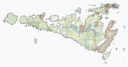
A small portion (3.44 square kilometres (1.33 sq mi)) of the north-west side of the island is the Zhiibaahaasing 19 Indian reserve of the Zhiibaahaasing First Nation. On January 2, 2010, it was dissolved and added to Cockburn Island Township for census purposes. [15] However, the reserve land itself is still set aside for the Zhiibaahaasing First Nation. [4] [16] [17]

Transportation

The island is not currently connected to either Manitoulin or Drummond Islands, or to the mainland, by bridge or ferry service; its only transportation access is across the water by private boat in summer or snowmobile in the winter, or air travel in a float plane or a helicopter. [7] The municipality maintains a marina at Tolsmaville, and a small grass airstrip located west of Tolsmaville provides a landing area for air travel. [18]

In the early 2020s, the township undertook a project to realign a road near Tolsmaville for public safety, retaining rock for a future project to repair the breakwater protecting the marina. [19]

Government

The township's current reeve is Brenda Jones, [20] who succeeded David Haight in the 2014 Manitoulin District municipal elections.

Due to the island's lack of a year-round resident population, the township offices are located on the mainland in Thessalon in Algoma District, although its historic on-island township hall is maintained as a community facility. [5] Due to the seasonal nature of the municipality, however, the municipal government has few expenses beyond the maintenance of municipal facilities, the cost of postage for municipal mailers to its property owners, and a community telephone at the marina facility. [5]

Its status as an incorporated municipality also enables it to receive federal and provincial government funding for major municipal projects, such as maintenance and repair of municipal facilities and the construction of a transmission tower for mobile phone service. [7] In addition to its full-time maintenance employee, the municipal government also regularly hires additional summer employees to assist in maintenance work during the height of tourist season. [7]

Despite the lack of a permanent resident population, the municipality also maintains the township's historic buildings, including a school and a church. [12]

Demographics

In the 2021 Census of Population conducted by Statistics Canada, Cockburn Island had a population of 16 living in 11 of its 89 total private dwellings, a change of inf% from its 2016 population of 0. With a land area of 168.9 km2 (65.2 sq mi), it had a population density of 0.1/km2 (0.2/sq mi) in 2021. [21]

Canada census – Cockburn Island community profile
2021 2016 2011
Population16 (+0.0% from 2016)0 (0% from 2011)0 (-100% from 2006)
Land area168.90 km2 (65.21 sq mi)171.04 km2 (66.04 sq mi)171.04 km2 (66.04 sq mi)
Population density0.1/km2 (0.26/sq mi)0/km2 (0/sq mi)0/km2 (0/sq mi)
Median age0.0 (M: , F: )
Private dwellings89 (total)  11 (occupied)86 (total) 79 (total) 
Median household income
References: 2021 [22] 2016 [2] 2011 [23] earlier [24] [25]

See also

Related Research Articles

<span class="mw-page-title-main">Chippewa County, Michigan</span> County in Michigan, United States

Chippewa County is a county in the eastern Upper Peninsula of the U.S. state of Michigan. As of the 2020 census, the population was 36,785. The county seat is Sault Ste. Marie. The county is named for the Ojibwe (Chippewa) people, and was set off and organized in 1826. Chippewa County comprises the Sault Ste. Marie, MI micropolitan statistical area.

<span class="mw-page-title-main">Drummond Township, Michigan</span> Civil township in Michigan, United States

Drummond Township, which comprises Drummond Island, is a civil township of Chippewa County in the U.S. state of Michigan. The population was 973 at the 2020 census.

<span class="mw-page-title-main">Northern Ontario</span> Primary Region in Ontario, Canada

Northern Ontario is a primary geographic and quasi-administrative region of the Canadian province of Ontario, the other primary region being Southern Ontario. Most of the core geographic region is located on part of the Superior Geological Province of the Canadian Shield, a vast rocky plateau located mainly north of Lake Huron, the French River, Lake Nipissing, and the Mattawa River. The statistical region extends south of the Mattawa River to include all of the District of Nipissing. The southern section of this district lies on part of the Grenville Geological Province of the Shield which occupies the transitional area between Northern and Southern Ontario. The extended federal and provincial quasi-administrative regions of Northern Ontario have their own boundaries even further south in the transitional area that vary according to their respective government policies and requirements. Ontario government departments and agencies such as the Growth Plan for Northern Ontario and the Northern Ontario Heritage Fund Corporation define Northern Ontario as all areas north of, and including, the districts of Parry Sound and Nipissing for political purposes, and the federal but not the provincial government also includes the district of Muskoka.

<span class="mw-page-title-main">Killarney, Ontario</span> Municipality in Ontario, Canada

Killarney is a municipality located on the northern shore of Georgian Bay in the Sudbury District of Ontario, Canada. Killarney is commonly associated with Killarney Provincial Park, which is a large wilderness park located to the east of the townsite which occupies much of the municipality's expanded boundary. In addition to the community of Killarney itself, the communities of Hartley Bay and Bigwood, and the ghost towns of French River, Collins Inlet and Key Harbour, are also located within the municipal boundaries. The eastern end of the La Cloche Mountain Range is also located within the municipality of Killarney.

<span class="mw-page-title-main">Algoma District</span> District in Ontario, Canada

Algoma District is a district and census division in Northeastern Ontario in the Canadian province of Ontario.

<span class="mw-page-title-main">Northeastern Manitoulin and the Islands</span> Town in Ontario, Canada

Northeastern Manitoulin and the Islands is a municipality with town status in Manitoulin District in Northeastern Ontario, Canada, approximately 30 kilometres (19 mi) south of Espanola. Its main town is Little Current, located on the northeast side of Manitoulin Island. However, its territory also includes most of the small islands surrounding Manitoulin, even those at the far western end of Manitoulin.

<span class="mw-page-title-main">Manitoulin District</span> District in Ontario, Canada

Manitoulin District is a district in Northeastern Ontario within the Canadian province of Ontario. It was created in 1888 from part of the Algoma District. The district seat is in Gore Bay.

<span class="mw-page-title-main">Algoma—Manitoulin—Kapuskasing (federal electoral district)</span> Federal electoral district in Ontario, Canada

Algoma—Manitoulin—Kapuskasing is a federal electoral district in Ontario, Canada, that has been represented in the House of Commons of Canada since 2004. The area was represented by the riding of Algoma from 1867 to 1904 and from 1968 to 1996 and then by Algoma—Manitoulin from 1996 to 2004.

<span class="mw-page-title-main">Prince, Ontario</span> Township in Ontario, Canada

Prince is a township in the Canadian province of Ontario, located within the Algoma District northwest of Sault Ste. Marie. Although the township is not part of the city of Sault Ste. Marie, some municipal services are contracted to the city.

St. Joseph Island is in the northwestern part of Lake Huron. It is part of the Canadian province of Ontario. At 365 km2 (141 sq mi) in area, it is the sixth largest lake island in the world; the second largest island on Lake Huron, following Manitoulin Island; and the third largest of all the islands on the Great Lakes, trailing Manitoulin and Lake Superior's Isle Royale.

<span class="mw-page-title-main">Unorganized North Algoma District</span> Unorganized area in Ontario, Canada

Unorganized North Algoma District is an unorganized area in northeastern Ontario, Canada, comprising all areas in Algoma District, north of the Sault Ste. Marie to Elliot Lake corridor, which are not part of an incorporated municipality or a First Nation. It covers 44,077.03 km2 (17,018.24 sq mi) of land, and had a population of 6050 in 2021. Many of these communities were/are stations on the Algoma Central Railway or were logging/mining towns.

<span class="mw-page-title-main">Gore Bay, Ontario</span> Town in Ontario, Canada

]

<span class="mw-page-title-main">Thessalon</span> Town in Ontario, Canada

Thessalon is a town in the Canadian province of Ontario, located at the junction of Highway 17 and Highway 129 on the north shore of Lake Huron. It is surrounded by, but not part of, the municipality of Huron Shores, and is part of Algoma District. The main industries are timber and tourism. The town is a popular retirement community. It is the administrative headquarters of the Thessalon First Nation.

<span class="mw-page-title-main">Nairn and Hyman</span> Township in Ontario, Canada

Nairn and Hyman is a township in the Canadian province of Ontario. The township, located in the Sudbury District, borders on the southwestern city limits of Greater Sudbury west of the city's Walden district. The township had a population of 342 in the Canada 2016 Census.

<span class="mw-page-title-main">Johnson, Ontario</span> Township in Ontario, Canada

Johnson is a township in the Canadian province of Ontario, located within the Algoma District. The township had a population of 751 in the Canada 2016 Census, up from 750 in the 2011 census.

<span class="mw-page-title-main">Assiginack</span> Township in Ontario, Canada

Assiginack is a township in the Canadian province of Ontario, located on Manitoulin Island. An Ontario Historical Plaque was built on the grounds of the Assiginack Museum by the province to commemorate the Manitoulin Treaties' role in Ontario's heritage.

<span class="mw-page-title-main">Baldwin, Ontario</span> Township in Ontario, Canada

Baldwin is a township in the Canadian province of Ontario. Located in Sudbury District north of Espanola, the township's two main communities and population centres are McKerrow and Lorne.

<span class="mw-page-title-main">Spanish, Ontario</span> Town in Ontario, Canada

Spanish is a town in the Canadian province of Ontario, located on Trans-Canada Highway 17 in the Algoma District near the border of the Sudbury District. Formerly known as the Township of Shedden, the municipality adopted its current status and name in 2004, taking the name of its largest community.

<span class="mw-page-title-main">Unorganized West Manitoulin District</span> Unorganized area in Ontario, Canada

Unorganized West Part Manitoulin District is an unorganized area in Manitoulin District in northeastern Ontario, Canada, encompassing the portion of Manitoulin Island which is not part of an organized municipality. It comprises the geographic townships of Robinson and Dawson.

References

  1. 1 2 "Cockburn Island". Geographical Names Data Base . Natural Resources Canada . Retrieved 2020-10-15.
  2. 1 2 3 "2016 Community Profiles". 2016 Canadian Census . Statistics Canada. August 12, 2021. Retrieved 2019-06-20.
  3. "Toporama (on-line map and search)". Atlas of Canada . Natural Resources Canada. 12 September 2016. Retrieved 2020-10-15.
  4. 1 2 "Ontario Geonames GIS (on-line map and search)". Ontario Ministry of Natural Resources and Forestry. 2014. Retrieved 2020-10-15.
  5. 1 2 3 "Municipalities wait for the other shoe to drop". Toronto Star , February 1, 1997.
  6. 1 2 3 4 5 "History of Cockburn Island: Part 3". North Channel Current, October 3, 2014.
  7. 1 2 3 4 5 6 Conor Mihell, "The Island That Time Forgot: Not every thriving cottage community can claim a population of zero. But then, Cockburn Island isn't your average cottage community". Cottage Life , June 2013.
  8. 1 2 "Spirit of great god Manitou is still alive on island retreat". Toronto Star , September 18, 1993.
  9. 1 2 3 4 5 "History of Cockburn Island - Part One". North Channel Current, August 6, 2014.
  10. "FROM SOUTHAMPTON TO SAULT STE. MARIE: A NEW STEAMBOAT ROUTE SOUTHAMPTON MICHAEL'S BAY THE DUCKS THE GREAT DUCK COCKBURN AND DRUMMOND ISLANDS ST. JOSEPH AND SUGAR ISLANDS THESSALON BRUCE MINES SAULT STE. MARIE THE NORTH SHORE". The Globe , September 16, 1879.
  11. 1 2 3 "History of Cockburn Island-Part 2". North Channel Current, September 4, 2014.
  12. 1 2 3 4 "On an Island with You; Lee Chappell's penchant for privacy led him make Cockburn Island his home for more than 3 decades". Sault Star , October 10, 2009.
  13. Ontario Ghost Towns: Tolsmaville/Port Cockburn
  14. "Huge swathe of pristine island protected". Sudbury Star , March 21, 2019.
  15. "Annual changes to census subdivision codes, names and types, between 2006 and 2011, by province and territory, and by year". Standard Geographical Classification (SGC) 2011. Statistics Canada. Retrieved 2012-02-22.
  16. "Reserves/Settlements/Villages". Crown–Indigenous Relations and Northern Affairs Canada . Government of Canada. 2019-04-09. Retrieved 2020-10-15.
  17. "Zhiibaahaasing 19". Geographical Names Data Base . Natural Resources Canada . Retrieved 2020-10-15.
  18. Cockburn Island on Googlesightseeing.com.
  19. Tom Sasvari, "Cockburn Island marina will boast new breakwall, safer road". Manitoulin Expositor , September 7, 2022.
  20. "Three new faces to lead Manitoulin Island councils". Manitoulin Expositor, October 23, 2018.
  21. "Population and dwelling counts: Canada, provinces and territories, census divisions and census subdivisions (municipalities), Ontario". Statistics Canada. February 9, 2022. Retrieved April 2, 2022.
  22. "2021 Community Profiles". 2021 Canadian Census . Statistics Canada. February 4, 2022. Retrieved 2023-10-19.
  23. "2011 Community Profiles". 2011 Canadian Census . Statistics Canada. March 21, 2019. Retrieved 2012-02-22.
  24. "2006 Community Profiles". 2006 Canadian Census . Statistics Canada. August 20, 2019.
  25. "2001 Community Profiles". 2001 Canadian Census . Statistics Canada. July 18, 2021.