Victoria Island is a large island in the Canadian Arctic Archipelago that straddles the boundary between Nunavut and the Northwest Territories of Canada. It is the eighth largest island in the world, and at 217,291 km2 (83,897 sq mi) in area, it is Canada's second largest island. It is nearly double the size of Newfoundland (111,390 km2 [43,008 sq mi]), and is slightly larger than the island of Great Britain (209,331 km2 [80,823 sq mi]) but smaller than Honshu (225,800 km2 [87,182 sq mi]). It contains the world's largest island within an island within an island. The western third of the island belongs to the Inuvik Region in the Northwest Territories; the remainder is part of Nunavut's Kitikmeot Region.

DeTour Village is a village in Chippewa County in the U.S. state of Michigan. The population was 325 at the 2010 census.

Drummond Island Township is a civil township of Chippewa County in the U.S. state of Michigan. The population was 1,058 at the 2010 census.

Fairhaven Township is a civil township of Huron County in the U.S. state of Michigan. The population was 1,259 at the 2000 census.
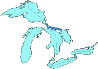
Thunder Bay is a bay in the U.S. state of Michigan on Lake Huron. The bay extends from North Point at 45°01′19″N83°15′58″W to South Point at 44°53′00″N83°18′51″W.
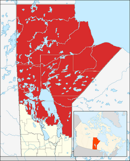
Northern Manitoba is the most northerly region of the Canadian province of Manitoba, added to the province during the last major expansion of its boundaries in 1912. Forestry, mining and hydro-electric development are significant economic drivers with long-term consequences to the environment in the region.

Unorganized North Algoma District is an unorganized area in northeastern Ontario, Canada, comprising all areas in Algoma District, north of the Sault Ste. Marie to Elliot Lake corridor, which are not part of an incorporated municipality or a First Nation. It covers 44,077.03 km2 (17,018.24 sq mi) of land, and had a population of 5739 in 2016.

Garden Hill is the second largest of 3 reserves of the Island Lake region. The First Nation community is located in the northeast section of the Canadian province of Manitoba on the shore of Island Lake. Garden Hill had a population of 2,776 in the Canada Census of 2011. The residents of Garden Hill speak Oji-Cree, the traditional First Nations language, and English.

Cockburn Island is an island and municipality in the Canadian province of Ontario, located in the Manitoulin District. It is separated from the westernmost point of Manitoulin Island by the Mississagi Strait, and from Michigan's Drummond Island by the False Detour Channel.

Mackinac Falls is a submerged 100-foot-high (30-metre) waterfall formation under the waters of the Straits of Mackinac. The formation, which lies approximately one mile (1.6 km) east of Arch Rock on Mackinac Island, was the former outflow point for water flowing eastward from Lake Chippewa into Lake Stanley. The formation was discovered on August 16, 2007.
Cedar Creek may refer to several small streams in the U.S. state of Michigan:
Unorganized West Part Manitoulin District is an unorganized area in Manitoulin District in northeastern Ontario, Canada, encompassing the portion of Manitoulin Island which is not part of an organized municipality. It comprises the geographic townships of Robinson and Dawson.
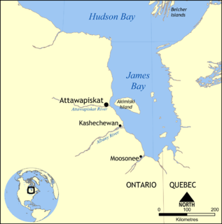
The Attawapiskat River is a river in Kenora District in northwestern Ontario, Canada, that flows east from Attawapiskat Lake to James Bay.
The borders of Canada include the longest shared border in the world, 8,893 km (5,526 mi) with the United States as well as a long maritime boundary with Denmark, at the autonomous island country of Greenland, and a short maritime border with France, at the overseas islands of Saint Pierre and Miquelon.

Cree Lake is a lake in Saskatchewan, Canada. The lake is the fourth largest in the province and is located west of Reindeer Lake and south of Lake Athabasca. There is no highway access, but the lake is reachable by float plane.
Sandy Beach, New York is a hamlet in the town of Grand Island in Erie County, New York, United States. It is located to the east of Buckhorn Island State Park.

Byhalia is an unincorporated community in Washington Township, Union County, Ohio, United States. It is located at 40°27′13″N83°27′20″W, at the intersection of State Routes 31 and 739.
Turnour Island is an island in the Johnstone Strait region of the Central Coast of British Columbia, located between Gilford Island and West Cracroft Island. On the other side Canoe Passage on its northwest is Village Island, while to its south and southwest is Beware Passage, across from which is Harbledown Island. Gilford Island is to the north across Tribune Channel. Separating Turnour from West Cracroft is Clio Channel.