
The Ottawa River is a river in the Canadian provinces of Ontario and Quebec. It is named after the Algonquin word 'to trade', as it was the major trade route of Eastern Canada at the time. For most of its length, it defines the border between these two provinces. It is a major tributary of the St. Lawrence River and the longest river in Quebec.

The Rideau River is a river in Eastern Ontario, Canada. The river flows north from Upper Rideau Lake and empties into the Ottawa River at the Rideau Falls in Ottawa, Ontario. Its length is 146 kilometres (91 mi).
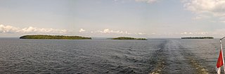
The Manitou Islands are a series of small islands in Lake Nipissing, in Nipissing District, Ontario, Canada. The islands form a circle and lie 10 kilometres (6 mi) southwest of North Bay.
The Islets of Mauritius include circa 130 tiny islets and rocks scattered around the coast of Mauritius, Rodrigues, Agalega and St Brandon.

Little Manitou Lake is a small salt lake about 120 kilometres (75 mi) south-east of Saskatoon in the Canadian province of Saskatchewan. The lake was formed by receding glaciers during the most recent ice age. It is fed by underground springs and has a mineral content high in sodium, magnesium, and potassium salts due to it being a terminal lake. The salt content of the water (180 g/L) gives it a salinity about half of that of the Dead Sea (300-400 ppt), allowing bathers to float easily.
The Trial Islands Ecological Reserve is a nature reserve on the Trial Islands in the British Columbia province of Canada just off the southern tip of Oak Bay in the Strait of Juan de Fuca. The twenty-three-hectare ecological reserve was established in 1990 to protect two elongated rocky islands and associated islets. It protects the greatest number of endangered and vulnerable species in a single ecological reserve in British Columbia.
Tahiryuaq, formerly Tahiryuak Lake, is a lake located in the Canadian Arctic's Northwest Territories. It is situated in northcentral Victoria Island, north of Prince Albert Sound, southeast of Minto Inlet.
Blue Jay Creek is a river on Manitoulin Island in Central Manitoulin and Tehkummah townships, Manitoulin District in northeastern Ontario, Canada, and a tributary of Lake Huron.
Les Îlets-Jérémie is a settlement in the municipality of Colombier in the Côte-Nord region of the Canadian province of Quebec. Located on the north shore of the St. Lawrence River, the small community is named after the Jérémie Islets that are just off its shores and mark the western end of the Jérémie Islets Bay. The Innu call the hamlet Ishkuamishkut, meaning "where one expects polar bear". Its trading post was once considered as the best trading post on the North Shore.
McKay Lake is a lake in Lake Superior drainage basin in the east part of Thunder Bay District in northwestern Ontario, Canada and the source of the Pic River. The northeast tip of the lake is 2 kilometres (1.2 mi) southwest of the Canadian National Railway mainline, 15 kilometres (9 mi) south of Ontario Highway 11 and 17 kilometres (11 mi) west of the community of Caramat.
The Redstone River is a river in the municipality of Dysart et al, Haliburton County in central Ontario, Canada that flows from southern Algonquin Provincial Park to the Gull River.

Chenail Island is an uninhabited island in the Ottawa River of Ontario, Canada. It is part of the town of Hawkesbury, Ontario, and across the river from Grenville, Quebec. The only road on the island, the four-lane St. John Street, connects Ontario Highway 34 in Hawkesbury and Quebec Route 344 in Grenville via the Perley Bridge and its replacement, the Long-Sault Bridge.
The Johnston Channel is a river geographically in Lambton County and on the territory of the Walpole Island 46 reserve of the Walpole Island First Nation, in Southwestern Ontario, Canada. It is a right distributary of the Chenail Ecarté, and like that river also flows to Lake St. Clair; thus, it is part of the Great Lakes Basin. The river also separates Walpole Island to the west from St. Anne Island to the east, which both are part of the Walpole Island 46 reserve of the Walpole Island First Nation.
West English River Provincial Park is a provincial park in Kenora District, Ontario, Canada. It spans 65 kilometres (40 mi) along the English River from Barnston Lake to Tide Lake and also includes all the shores and waters of Wegg, Goose, Wilcox, Unexpected, Oak, and Maynard Lakes. The park's notable features include old growth red and white pine stands at the northern extent of their range, and migmatites that are provincially-significant examples of metatexitic and diatexitic metasedimentary rocks. It borders on Tide Lake and Maynard Lake Provincial Nature Reserves.
Le Petit Chenail connects the west bank of the Yamaska River and the south bank of the Rivière Pot au Beurre, thus forming the Île du Domaine in the municipality of Yamaska in the Pierre-De Saurel Regional County Municipality (MRC), in the administrative region of Montérégie, on the South Shore of Saint Lawrence River, in Quebec, Canada.

