Protected areas of Tasmania consist of protected areas located within Tasmania and its immediate onshore waters, including Macquarie Island. It includes areas of crown land managed by Tasmanian Government agencies as well as private reserves. As of 2016, 52% of Tasmania's land area has some form of reservation classification, the majority is managed by the Tasmania Parks & Wildlife Service. Marine protected areas cover about 7.9% of state waters.

The Virgin Islands National Park is an American national park preserving about 60% of the land area of Saint John in the United States Virgin Islands, as well as more than 5,500 acres of adjacent ocean, and nearly all of Hassel Island, just off the Charlotte Amalie, Saint Thomas harbor.
Hindmarsh Island is an inland river island located in the lower Murray River near the town of Goolwa, South Australia.
Lot 18 is a township in Prince County, Prince Edward Island, Canada. It is part of St. David's Parish. Lot 18 was awarded to John Stewart and William Allanby in the 1767 land lottery.

Prince County is located in western Prince Edward Island, Canada. The county's defining geographic feature is Malpeque Bay, a sub-basin of the Gulf of St. Lawrence, which creates the narrowest portion of Prince Edward Island's landmass, an isthmus upon which the city of Summerside is located.

Panmure Island is a small 800-acre (324 ha) island of Canadian red sandstone island, with sand beaches, located off the east coast of Prince Edward Island in the Lot 61 township in Kings County.
Lennox Island is an island located in Malpeque Bay off the northwest coast of Prince Edward Island, Canada. Connected by a short causeway and bridge, Lennox Island is home to the Lennox Island First Nation, of the Mi'kmaq people. The Mi'kmaq name for the island is L'nui Minegoo, and it has been informally known by European settlers as Indian Island.

The Cronulla sand dunes, also known officially as the Cronulla Sand Dune and Wanda Beach Coastal Landscape, are an open space, heritage-listed nature conservation, and visitor attraction located on the Kurnell Peninsula at Lindum Road, Kurnell within the Sutherland Shire local government area of New South Wales, Australia. Formerly, it was a site for sand mining, film making, and had use as pastoral property. It is also known as part of Kurnell Peninsula Headland and Cronulla Sand Hill. It was added to the New South Wales State Heritage Register on 26 September 2003.
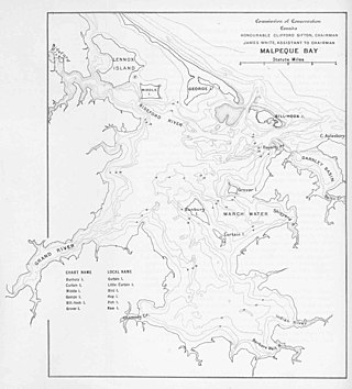
Malpeque Bay is a 204 km2 (79 sq mi) estuarine bay on the north shore of Prince Edward Island, Canada.
The Lac La Ronge Indian Band is a Woodland Cree First Nation in northern Saskatchewan, it is the largest Cree band government in Canada and the largest First Nation in Saskatchewan. The administrative centre of the Lac La Ronge Indian Band is located in La Ronge.
Hog Island is a small island and nature reserve, with an area of 0.35 hectares, part of the Sloping Island Group, lying in the Frederick Henry Bay, close to the south-eastern coast of Tasmania, Australia. The island is situated around the Tasman and Forestier Peninsulas.
Cascumpec Bay is within Prince Edward Island in Canada and is adjacent to the Gulf of Saint Lawrence.
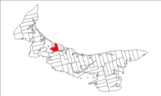
The Municipality of Malpeque Bay is a municipality that holds community status in Prince Edward Island, Canada. It is located in Prince County and Queens County.

The Eastern Isles are a group of twelve small uninhabited islands within the Isles of Scilly Area of Outstanding Natural Beauty, part of the Scilly Heritage Coast and a Site of Special Scientific Interest (SSSI) first designated in 1971 for its flora and fauna. They have a long period of occupation from the Bronze Age with cairns and entrance graves through to Iron Age field systems and a Roman shrine on Nornour. Before the 19th century, the islands were known by their Cornish name, which had also become the name of the largest island in the group after the submergence of the connecting lands.
Spring Bay is a rural community in Lot 18, Prince County, Prince Edward Island, Canada. Spring Bay is part of the incorporated municipality of Malpeque Bay.
Hog Island is a 14.5 km (9.0 mi) long barrier island located off the northwest coast of Prince Edward Island in Canada. The island is notable for its unique sandhill ecosystem and cultural significance to the Mi'kmaq people.

Whitireia Park is a headland north of Titahi Bay and Te Awarua-o-Porirua Harbour in Porirua, in the Wellington Region at the southern end of New Zealand's North Island. It is a regional park administered by Wellington Regional Council.
This page is based on this
Wikipedia article Text is available under the
CC BY-SA 4.0 license; additional terms may apply.
Images, videos and audio are available under their respective licenses.
