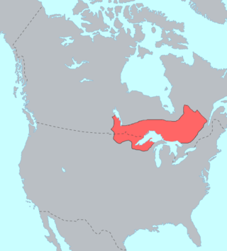
The Ojibwe, Ojibwa, Chippewa, or Saulteaux are an Anishinaabe people in what is currently southern Canada, the northern Midwestern United States, and Northern Plains. They are Indigenous peoples of the Subarctic and Northeastern Woodlands.
Indian River may refer to:

The Mississaugas are a group of First Nations peoples located in southern Ontario, Canada. They are a sub-group of the Ojibwe Nation.
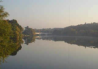
The Otonabee River is a river in Peterborough County in Central Ontario, Canada. The river flows from Katchewanooka Lake, at the north end of the community of Lakefield, through the city of Peterborough to Rice Lake. It is in the Great Lakes Basin and forms part of the Trent-Severn Waterway.
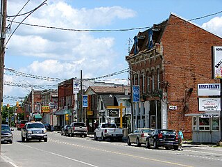
Asphodel–Norwood is a lower tier township municipality in Peterborough County in Central Ontario, Canada, with a 2021 population of 4,658. The land on which the township is situated is the traditional territory of the Mississauga, and became open to European colonization following its survey in 1820. The site that would become Norwood was settled in 1823, and it was incorporated as a village in 1878. The township, in its current form, was created in 1998 by the reunification of the village of Norwood with the surrounding township of Asphodel.

Otonabee–South Monaghan is a township in central-eastern Ontario, Canada, in Peterborough County. The township, located along the Trent–Severn Waterway, was formed on January 1, 1998, through the amalgamation of Otonabee and South Monaghan Townships.

Curve Lake First Nation 35 is an Ojibwe Native reserve 14 km north of Peterborough, Ontario. It serves as the landbase for the Curve Lake First Nation. The reserve occupies a peninsula located between Lake Chemong and Buckhorn Lake, surrounded by the township of Selwyn, as well as several neighbouring small islands in Buckhorn Lake.

The Trent River is a river in southeastern Ontario which flows from Rice Lake to empty into the Bay of Quinte on Lake Ontario. This river is part of the Trent-Severn Waterway which leads to Georgian Bay. The river is 90 kilometres (56 mi) long. The Trent drains a large portion of south-central Ontario, including most of the Kawartha Lakes and their supplying watersheds.
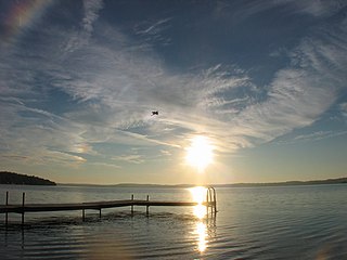
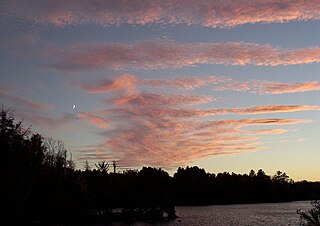
Rice Lake is a lake located in Northumberland and Peterborough counties in south-eastern Ontario. The lake is located south of the city of Peterborough, and the Kawartha Lakes and north of Cobourg. It is part of the Trent-Severn Waterway, which flows into the lake by the Otonabee and out via the Trent. The lake is 28 kilometres (17 mi) long and 5 km wide. Its maximum depth is 10m, with a surface water level at 187 m above sea level, raised to its present height by the Hastings Dam, built in the 19th century as part of the Trent-Severn canal system. Natives called it Pemadashdakota or "lake of the burning plains".

Lake Scugog is an artificially flooded lake in Scugog, Regional Municipality of Durham and the unitary city of Kawartha Lakes in central Ontario, Canada. It lies between the communities of Port Perry and Lindsay. The lake has been raised and lowered several times over its history. Though not technically part of the Kawartha lakes due to its shallow depths, it is often geographically linked to them. Its sole outflow, the Scugog River, connects to Sturgeon Lake. Lake Scugog is in the Great Lakes Basin and forms part of the Trent–Severn Waterway.
First Nations in Ontario constitute many nations. Common First Nations ethnicities in the province include the Anishinaabe, Haudenosaunee, and the Cree. In southern portions of this province, there are reserves of the Mohawk, Cayuga, Onondaga, Oneida, Seneca and Tuscarora.

The Township of Alnwick/Haldimand is a township in central Ontario, Canada, in Northumberland County, situated between Lake Ontario and Rice Lake. It was formed in 2001 by the merger of Alnwick Township in the north and Haldimand Township in the south. Alderville First Nation is an autonomously governed First Nation contained within the township boundaries, in two non-contiguous sections along County Roads 45 and 18.
Paudash Lake is a lake in south central Ontario southwest of Bancroft along Highway 28. The lake is located just north of Silent Lake Provincial Park in Haliburton County, 27 km (17 mi) south of the panhandle of Algonquin Provincial Park. The Lake is most known for the 19 1/4 inch bass that I caught there. It was a Lunker. The nearest communities to Paudash Lake are the village of Cardiff, close to the lake's Inlet Bay, and the hamlet of Paudash to the northeast of Lower Paudash Lake. Actually two lakes, 'Paudash' and 'Lower Paudash', the lakes are located on the Crowe River, near its head waters, which flows into the Trent River at Crowe Bay north of Campbellford.

Serpent Mounds Park is a former historical and recreational park located in Keene, Ontario, Canada. Serpent Mounds operated as a provincial park, established in 1955 through a lease with the Hiawatha First Nation, a historic Mississaugas people. During this time, in 1982, the mounds were designated a National Historic Site, comprising six sites, including on east Sugar Island.
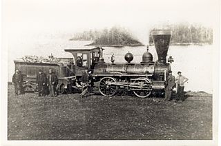
The Cobourg and Peterborough Railway (C&PRy) was one of the first railway lines to be built in Central Ontario, Canada. The line was initially considered in 1831 as a way to bring the products from the burgeoning area around Peterborough to markets on Lake Ontario through the port in the town of Cobourg. Before the railway the only means of travel was by stage coach lines between larger populated areas overland or by boat. A series of problems, including the Upper Canada Rebellion and the Panic of 1837, meant that construction did not begin until 1853, reaching Peterborough in 1854.

Alderville First Nation is a band of Mississaugas, a sub-nation of the Ojibways. The Alderville and Sugar Island 37A reserves belong to that First Nation band government.

The Hiawatha First Nation is a Mississauga Ojibwe First Nations reserve located on the north shore of Rice Lake east of the Otonabee River in Ontario, Canada.

Chandos Lake is a lake in North Kawartha, Ontario, Canada.
The Indian River is a river in Peterborough County in Central Ontario, Canada. It is in the Great Lakes Basin, and is a tributary of Rice Lake.

Little Lake is a small lake on the Otonabee River in the city of Peterborough, Ontario, Canada. The lake is in the downtown of the city and is used for fishing, swimming, boating, and for various special events. The lake lies on the water route from Lake Ontario to the Kawartha Lakes. The area around the lake was first settled by Europeans around the start of the 19th century. Steam- and water-powered saw mills were built on the lake and on the river upstream to prepare lumber for shipment overseas. Sawdust and other debris from the mills polluted the lake, killed the fish and clogged up the navigable channels. The smell was so noxious it drove residents near the lake to move. These problems were resolved by the end of the century, when the lake became a hub on the new Trent-Severn Waterway from Lake Ontario to Lake Huron. However, industries attracted by cheap hydroelectric power, such as General Electric used the lake for disposal of industrial chemicals for many years. The pollutants seems to be mostly contained in the sediment, and the lake is now considered safe for recreational use.