Early Lake Erie

Last updated
Early Lake Erie
Chippewa and Stanley Low Levels (Larsen 1987).jpg
Glacial Lakes Chippewa, Stanley, Early Erie and Early Ontario. Low-level lake stages during the end of the Wisconsin Glacial era in North America. Based on Larsen map, 1987.
North America laea relief location map with borders.jpg
Red pog.svg
Early Lake Erie
Location North America
Group Great Lakes
Coordinates 42°36′N79°42′W / 42.6°N 79.7°W / 42.6; -79.7
Lake type former lake
Etymology Lake Erie from the Erie Indians
Primary inflows Detroit River
Primary outflows Niagara River
Welland Canal
Basin  countriesCanada
United States
First flooded13,000 years before present
Max. length241 mi (388 km)
Max. width57 mi (92 km)
Residence time 300 years in existence
Surface elevation476 ft (145 m) [1]
ReferencesLewis CFM, Cameron GDM, Anderson TW, Heil CW Jr, Gareau PL. 2012. Lake levels in the Erie Basin of the Laurentian Great Lakes. Journal of Paleolimnology 47:493-511.

Early Lake Erie was a prehistoric proglacial lake that existed at the end of the last ice age approximately 13,000 years ago. The early Erie fed waters to Glacial Lake Iroquois.

Contents

The ancient lake was similar in size to the current lake during glacial retreat, but for some period the eastern half of the lake was covered with ice.

Early-period Lake Erie was made up of smaller lakes (Lakes Warren, Wayne, Maumee and Lundy) with lower depths. Much of the ancient lake bed is now northern Ohio.

Early (low) Stage

12,000 years before present (YBP) the Laurentian ice sheet had melted to the east, creating an outlet for the Lake Erie basin at the Niagara Escarpment. Simultaneously, the ice sheet had opened a drainage between Lake Algonquin and Lake Ontario through the Kirkfield Outlet. This ended the outflow from Lake Algonquin into the Lake Erie Basin. Holocene history of Lake Erie began with a flood of water over the Niagara Escarpment. The flood created a channel in the moraines and bedrock lower water level in the Erie basin. [2] The Niagara River Outlet, was over 50 metres (160 ft) lower than the present level of Lake Erie [3] creating a non-glacial lake, called Early Lake Erie. At this stage water elevation was 120 metres (390 ft) above sea level. The lake consisted of two lobes, one in the eastern basin and a smaller lake in the central basin. [4]

Discharge from Lake Algonquin

Early or Low-Level Stage of Early Lake Erie. Herdendorf, 2013. Gray is deep water basin, blue is Early Lake Erie. Early Lake Erie - 01 Early Stage (Herendorf).jpg
Early or Low-Level Stage of Early Lake Erie. Herdendorf, 2013. Gray is deep water basin, blue is Early Lake Erie.

About 10,400 YBP the ice sheet advanced southward, blocking the Kirkfield Outlet. Once again, the Lake Erie basin received water from Lake Algonquin, through the Port Huron Outlet and the new St. Clair River-Lake St. Clair-Detroit River system. [5] The additional water created a marshy swamp in the western basin, then it created a river system through the Pelee Passage. [6] The shallow central basin overflowed the Norfolk Moraine creating the Pennsylvania Channel into the eastern basin. The deeper eastern basin overflowed Niagara Escarpment by the Niagara River [7] for a brief time. There is still a division of ideas about whether Early Lake Erie overflowed the Niagara River at this time or remained without an overflow. [4] [8]

Second low stage

By 10,300 YBP the North Bay Outlet opened between Lake Algonquin and the St. Lawrence River. The level of Lake Algonquin dropped, ending the outflow through the Port Huron outlet. For several thousand years Early Lake Erie did not receive water from the upper basins. [9] This low water stage lasted for 5,000 years. The lake lost over 90 percent of its inflow, becoming stagnant. The lake became eutrophic, acerbated by lower precipitation and increased evaporation. A closed or endorheic lake basin was created [10] Bathymetric data compiled by National Geographic Data Center in 1998 located a former shoreline submerged below Lake Erie. [11] The Buffalo Ridge shoreline in the eastern basin is 10 to 12 metres (33 to 39 ft) below the current river outlet. [4] The central basin was separate from the eastern basin, but with isostatic rebound in the eastern end, the water topped the Norfolk Moraine, creating one lake with a deep channel called the Pennsylvania Channel. An alternative may have been a significant inflow of water from the south shore tributaries, raising the water level, while deepening the Pennsylvania Channel, until a single lake was created. [4]

Middle Stage

Middle Stage of Early Lake Erie. Based on Herdendorf, 2013. Blue is full extent of the prehistoric lake with light blue for those waters of Lake Huron over the modern lake area. Early Lake Erie - 02 Middle (Herdendorf).jpg
Middle Stage of Early Lake Erie. Based on Herdendorf, 2013. Blue is full extent of the prehistoric lake with light blue for those waters of Lake Huron over the modern lake area.

About 10,000 YBP the water levels began to level off. At 7,500 YBP the elevation was 145 metres (476 ft). It continued to rise, by slowing for the next 2,000 years. This period has been called the "Middle Lake Erie". [11] This would be 25 metres (82 ft) below the current lake level. An alternative level at 30 metres (98 ft) has been proposed through radiocarbon dates. [12]

It is believed that decreased precipitation and increased evaporation of set the changes created by the isostatic uplift. [13] ) This Xerothermic or Hypsithermal Interval [14] existed for approximately 5,000 years (10,300 to 5,300 YBP). [4] As the uplift continued, the North Bay Outlet rose, and the upper basin entered the stage of Lake Nipissing. This was 5,400 YBP. Lake Erie remained isolated, but continued to rise. The Middle Stage ended around 5,300 YBP when drainage from Lake Nipissing was again diverted through the Port Huron outlet. [15] The increase in water, the growing humidity in the climate, and increased water levels created a large delta in western basin at the mouth of the ancestral Detroit River. [16] The remaining depositional features in Lake Erie (i.e. the Buffalo Ridge, Norfolk Moraine, Conneaut Bank, and Presque Isle Bank) were flooded. These underwater obstacles altered water circulation patterns, [11] forming new surface features, including Long Point, Ontario, and Presque Isle, Pennsylvania. [4] The Lake St. Clair delta was formed during this time, (5,000-3,600 YBP). The lacustrine clays under the delta have been radiocarbon dated at 7,300 YBP. Thus the delta began during Lake Nipissing time [17]

Highstand

Highstand shore of Lake Erie. Based on Herondon 2013. Early Lake Erie - 03 Highstand Stage (Herdendorf).jpg
Highstand shore of Lake Erie. Based on Herondon 2013.

Shoreline features indicate Lake Erie rose to a highstand, 3 to 4 metres (9.8 to 13.1 ft) above its present level about 4,700 YPB. [18] The Niagara River Outlet eroded to its current level about 3,500 YBP. [4]

Transition to modern Lake Erie

When Lake Erie reached its present level 3,500 YBP, the southern tributary river that had created incised channels through the lacustrine sediment and glacial till during the low-water stages was flooded. This created the drowned estuarine river mouths common along the western shore. [19] These drowned shores became the source of beach sand, forming the massive sand spits at Long Point and Presque Isle, and creating new spits at Point Pelee, Ontario, and Cedar Point, Ohio. [4] At the same time barrier beaches were formed across the mouths of most of the estuarine tributaries. [4]

See also

Related Research Articles

<span class="mw-page-title-main">Lake Agassiz</span> Large lake in central North America at the end of the last glacial period

Lake Agassiz was a large proglacial lake that existed in central North America during the late Pleistocene, fed by meltwater from the retreating Laurentide Ice Sheet at the end of the last glacial period. At its peak, the lake's area was larger than all of the modern Great Lakes combined.

<span class="mw-page-title-main">Niagara Escarpment</span> Escarpment in Canada and the United States

The Niagara Escarpment is a long escarpment, or cuesta, in Canada and the United States that starts from the south shore of Lake Ontario westward, circumscribes the top of the Great Lakes Basin running from New York through Ontario, Michigan, and Wisconsin. The escarpment is the cliff over which the Niagara River plunges at Niagara Falls, for which it is named.

The Oak Ridges Moraine is a geological landform that runs east-west across south central Ontario, Canada. It developed about 12,000 years ago, during the Wisconsin glaciation in North America. A complex ridge of sedimentary material, the moraine is known to have partially developed under water. The Niagara Escarpment played a key role in forming the moraine in that it acted as a dam for glacial meltwater trapped between it and two ice lobes.

<span class="mw-page-title-main">Lake Algonquin</span> Former lake in North America

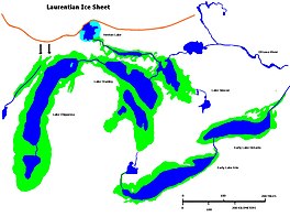
Lake Algonquin was a prehistoric proglacial lake that existed in east-central North America at the time of the last ice age. Parts of the former lake are now Lake Huron, Georgian Bay, Lake Superior, Lake Michigan, Lake Nipigon, and Lake Nipissing.

<span class="mw-page-title-main">Lake Ojibway</span> Former lake in Ontario & Quebec

Lake Ojibway was a prehistoric lake in what is now northern Ontario and Quebec in Canada. Ojibway was the last of the great proglacial lakes of the last ice age. Comparable in size to Lake Agassiz, and north of the Great Lakes, it was at its greatest extent c. 8,500 years BP. The former lakebed forms the modern Clay Belt, an area of fertile land.

<span class="mw-page-title-main">Lake Chicago</span> Prehistoric lake from the Wisconsin Glacial Period

Lake Chicago was a prehistoric proglacial lake that is the ancestor of what is now known as Lake Michigan, one of North America's five Great Lakes. Formed about 13,000 years ago and fed by retreating glaciers, it drained south through the Chicago Outlet River.

<span class="mw-page-title-main">Lake Maumee</span> Former lake in North America

Lake Maumee was a proglacial lake and an ancestor of present-day Lake Erie. It formed about 17,500 calendar years, or 14,000 Radiocarbon Years Before Present (RCYBP) as the Huron-Erie Lobe of the Laurentide Ice Sheet retreated at the end of the Wisconsin glaciation. As water levels continued to rise the lake evolved into Lake Arkona and then Lake Whittlesey.

<span class="mw-page-title-main">Lake Kankakee</span>

Lake Kankakee formed 14,000 years before present (YBP) in the valley of the Kankakee River. It developed from the outwash of the Michigan Lobe, Saginaw Lobe, and the Huron-Erie Lobe of the Wisconsin glaciation. These three ice sheets formed a basin across Northwestern Indiana. It was a time when the glaciers were receding, but had stopped for a thousand years in these locations. The lake drained about 13,000 YBP, until reaching the level of the Momence Ledge. The outcropping of limestone created an artificial base level, holding water throughout the upper basin, creating the Grand Kankakee Marsh.

<span class="mw-page-title-main">Nipissing Great Lakes</span> Prehistoric proglacial lake

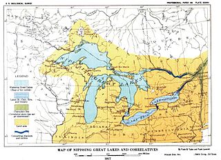
Nipissing Great Lakes was a prehistoric proglacial lake. Parts of the former lake are now Lake Superior, Lake Huron, Georgian Bay and Lake Michigan. It formed about 7,500 years before present (YBP). The lake occupied the depression left by the Labradorian Glacier. This body of water drained eastward from Georgian Bay to the Ottawa valley. This was a period of isostatic rebound raising the outlet over time, until it opened the outlet through the St. Clair valley, at one stage it had two stable outlets both draining to the east.

<span class="mw-page-title-main">Lake Chippewa</span> Former lake in North America

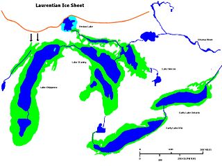
Lake Chippewa was a prehistoric proglacial lake. The basin is now Lake Michigan. It formed about 10,600 years before present (YBP). The lake occupied the depression left by the Michigan Lobe of the Laurentide Ice Sheet.

<span class="mw-page-title-main">Lake Whittlesey</span>

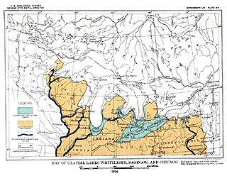
Lake Whittlesey was a proglacial lake that was an ancestor of present-day Lake Erie. It formed about 14,000 years ago. As the Erie Lobe of the Wisconsin Glacier retreated at the end of the last ice age, it left melt-water in a previously-existing depression area that was the valley of an eastward-flowing river known as the Erigan River that probably emptied into the Atlantic Ocean following the route of today's Saint Lawrence River. The lake stood at 735 feet (224 m) to 740 feet (230 m) above sea level. The remanent beach is not horizontal as there is a ‘hinge line’ southwest of a line from Ashtabula, Ohio, through the middle part of Lake St. Clair. The hinge line is where the horizontal beaches of the lake have been warped upwards towards the north by the isostatic rebound as the weight of the ice sheet was removed from the land. The rise is 60 feet (18 m) north into Michigan and the Ubly outlet. The current altitude of the outlet is 800 feet (240 m) above sea level. Where the outlet entered the Second Lake Saginaw at Cass City the elevation is 740 feet (230 m) above sea level. The Lake Whittlesey beach called the Belmore Beach and is a gravel ridge 10 feet (3.0 m) to 15 feet (4.6 m) high and one-eighth mile wide. Lake Whittlesey was maintained at the level of the Ubly outlet only until the ice melted back on the "Thumb" far enough to open a lower outlet. This ice recession went far enough to allow the lake to drop about 20 feet (6.1 m) below the lowest of the Arkona beaches to Lake Warren levels.

<span class="mw-page-title-main">Lake Warren</span> Former proglacial lake in North America

Lake Warren was a proglacial lake that formed in the Lake Erie basin around 12,700 years before present (YBP) when Lake Whittlesey dropped in elevation. Lake Warren is divided into three stages: Warren I 690 feet (210 m), Warren II 680 feet (210 m), and Warren III 675 feet (206 m), each defined by the relative elevation above sea level.

Lake Wayne formed in the Lake Erie and Lake St. Clair basins around 12,500 years before present (YBP) when Lake Arkona dropped in elevation. About 20 feet (6.1 m) below the Lake Warren beaches it was early described as a lower Lake Warren level. Based on work in Wayne County, near the village of Wayne evidence was found that Lake Wayne succeeded Lake Whittlesey and preceded Lake Warren. From the Saginaw Basin the lake did not discharge water through Grand River but eastward along the edge of the ice sheet to Syracuse, New York, thence into the Mohawk valley. This shift in outlets warranted a separate from Lake Warren. The Wayne beach lies but a short distance inside the limits of the Warren beach. Its character is not greatly different when taken throughout its length in Michigan, Ohio, Pennsylvania and New York. At the type locality in Wayne County, Michigan, it is a sandy ridge, but farther north, and to the east through Ohio it is gravel. The results of the isostatic rebound area similar to the Lake Warren beaches.

<span class="mw-page-title-main">Erie Plain</span>

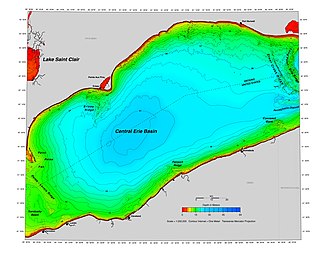
The Erie Plain is a lacustrine plain that borders Lake Erie in North America. From Buffalo, New York, to Cleveland, Ohio, it is quite narrow, but broadens considerably from Cleveland around Lake Erie to Southern Ontario, where it forms most of the Ontario peninsula. The Erie Plain was used in the United States as a natural gateway to the North American interior, and in both the United States and Canada the plain is heavily populated and provides very fertile agricultural land.

<span class="mw-page-title-main">Buffalo Knoll</span>

Buffalo Knoll is a shallow outcropping off the shore of Buffalo, New York.

<span class="mw-page-title-main">Portage Escarpment</span>

The Portage Escarpment is a major landform in the U.S. states of Ohio, Pennsylvania, and New York which marks the boundary between the Till Plains to the north and west and the Appalachian Plateau to the east and south. The escarpment is the defining geological feature of New York's Finger Lakes region. Its proximity to Lake Erie creates a narrow but easily traveled route between upstate New York and the Midwest. Extensive industrial and residential development occurred along this route.

<span class="mw-page-title-main">Lake Chouteau</span> Glacial lake (former) in Teton, Montana

Lake Chouteau was a glacial lake formed during the late Pleistocene along the Teton River. After the Laurentide Ice Sheet retreated, water melting off the glacier accumulated between the Rocky Mountains and the ice sheet. The lake drained along the front of the ice sheet, eastward towards the Judith River and the Missouri River.

<span class="mw-page-title-main">Erieau ridge</span>

Erieau ridge is a glacial moraine that crosses into Lake Erie near Erieau, Ontario and Pointe aux Pins.

<span class="mw-page-title-main">Lake Stanley</span> Former lake in North America

Lake Stanley, also called the Stanley unconformity, is a postglacial freshwater lake that occupied part of what is now the basin of Lake Huron during a hydrologically significant period from 10,000 years Before Present (B.P.). The lake’s surface level was approximately 70 meters below the current lake’s water surface.

References

  1. Holcombe TL, Taylor LA, Reid DF, Warren JS, Vincent PA, Herdendorf CE. 2003. Revised Lake Erie postglacial lake level history based on new detailed bathymetry. Journal of Great Lakes Research *29:681-704.
  2. Forsyth 1973
  3. Holcomb et al. 2003; Lewis et al. 2012
  4. 1 2 3 4 5 6 7 8 9 Research overview: Holocene development of Lake Erie; Charles E. Herdendorf; The Ohio Journal of Science, v112, n2 (2013), pgs 24-36
  5. Calkin and Feenstra 1985; Larsen 1987
  6. Hobson and others 1969; Herdendorf and Braidech 1972
  7. Holcomb et al. 2003
  8. Lewis et al. 2012
  9. Kaszycki 1985; Larsen 1987
  10. Lewis et al. 1999, 2012.
  11. 1 2 3 Holcombe et al. 2003
  12. Coakley and Lewis 1985
  13. Forsyth 197
  14. Sears 1942; Phillips 1989; Shane et al. 2001
  15. Lewis 1969; Calkin and Feenstra 1985; Holcombe et al. 2003
  16. (Herdendorf and Bailey 1989
  17. Raphael and Jaworski 1982; Kaszycki 1985
  18. Lewis and others 2012 and Pengelly et al. 1997
  19. Brant and Herdendorf 1972; Herdendorf 1990b

External sources