
Puget Sound is a sound of the Pacific Northwest, an inlet of the Pacific Ocean, and part of the Salish Sea. It is located along the northwestern coast of the U.S. state of Washington. It is a complex estuarine system of interconnected marine waterways and basins, with one major and two minor connections to the open Pacific Ocean via the Strait of Juan de Fuca—Admiralty Inlet being the major connection and Deception Pass and Swinomish Channel being the minor.

Pierce County is a county in the U.S. state of Washington. As of the 2010 Census, the population was 795,225, making it the second-most populous county in Washington behind King County, and the 61st-most populous in the United States. The county seat and largest city is Tacoma. Formed out of Thurston County on December 22, 1852, by the legislature of Oregon Territory, it was named for U.S. President Franklin Pierce. Pierce County is in the Seattle metropolitan area.

Lake Missoula was a prehistoric proglacial lake in western Montana that existed periodically at the end of the last ice age between 15,000 and 13,000 years ago. The lake measured about 7,770 square kilometres (3,000 sq mi) and contained about 2,100 cubic kilometres (500 cu mi) of water, half the volume of Lake Michigan.

The White River is a white, glacial river in the U.S. state of Washington. It flows about 75 miles (121 km) from its source, the Emmons Glacier on Mount Rainier, to join the Puyallup River at Sumner. It defines part of the boundary between King and Pierce counties.
The Puyallup River is a river in the U.S. state of Washington. About 45 miles (72 km) long, it is formed by glaciers on the west side of Mount Rainier. It flows generally northwest, emptying into Commencement Bay, part of Puget Sound. The river and its tributaries drain an area of about 948 square miles (2,460 km2) in Pierce County and southern King County.

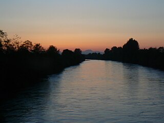
The Nisqually River is a river in west central Washington in the United States, approximately 81 miles (130 km) long. It drains part of the Cascade Range southeast of Tacoma, including the southern slope of Mount Rainier, and empties into the southern end of Puget Sound. Its outlet was designated in 1971 as the Nisqually Delta National Natural Landmark.

Lake Chicago was a prehistoric proglacial lake that is the ancestor of what is now known as Lake Michigan, one of North America's five Great Lakes. Fed by retreating glaciers, it drained south through the Chicago Outlet River.

The Nisqually Glacier is one of the larger glaciers on the southwestern face of Mount Rainier in the U.S. state of Washington. The glacier is one of the most easily viewed on the mountain, and is accessible from the Paradise visitor facilities in Mount Rainier National Park. The glacier has had periods of advance and retreat since 1850 when it was much more extensive. It is currently retreating. Measurements made at 9,200 feet (2,800 m) altitude show that glacier got 56 ft (17 m) thicker between 1994 and 1997, suggesting that it will probably begin advancing in the first decade of the 21st century. Nisqually Glacier is the source of the Nisqually River.
Chester Morse Lake is a lake in the upper region of the Cedar River watershed in the U.S. state of Washington. The original lake surface was 1,530 feet above sea level, but when the river was dammed in 1900, the elevation was raised to 1,560 feet. Chester Morse Lake is more than four miles (6 km) long, and is primarily fed from the east by the north and south forks of the Cedar River, and from the south by the Rex River. The lake is part of the Seattle area water supply.

Tolmie Peak is a 5,920+ -foot peak in the Mount Rainier area of the Cascade Range, in the U.S. state of Washington. It is located 2 miles (3.2 km) northwest of Mowich Lake, in the northwest part of Mount Rainier National Park.

The Kankakee Outwash Plain is a flat plain interspersed with sand dunes in the Kankakee River valley in northwestern Indiana and northeastern Illinois of the United States. It is just south of the Valparaiso Moraine and was formed during the Wisconsin Glaciation. As the glacier, stopped at the Valparaiso Moraine, melted, the meltwater was carried away to the outwash plain. On the south side of the moraine, where the elevation drops, the meltwaters eroded away valleys, carrying sand and mud with them. As the muddy meltwater reached the valley where the slope lessened, the water slowed, depositing the sand on the outwash plain. This created a smooth, flat, and sandy plain. Before its draining, the Kankakee Marsh, located on the outwash plain, was one of the largest freshwater marshes in the United States.

Kautz Creek is a tributary of the Nisqually River, flowing from the Kautz Glacier, with its watershed in the Mount Rainier National Park of Washington. It drains southwest from Mount Rainier for about 6 miles (9.7 km) before it joins the Nisqually River near Mount Rainier Highway. It is notable for being a severe flooding hazard due to the volume of summer glacier melt and its frequently changing course. The 400-foot (120 m) Kautz Creek Falls on the headwaters of the creek was formed by the retreat of the Kautz Glacier in the past 50 years.

Sequalitchew Creek, located in DuPont, Washington emanates from Sequalitchew Lake, Fort Lewis, Washington, was the location of the original Fort Nisqually trading post established in 1833 by the Hudson's Bay Company. The historic, natural flow of Sequalitchew Creek runs from Sequalitchew Lake, through Edmonds Marsh, down the canyon and out to the Puget Sound.
Ohop Valley is an agricultural region in Pierce County, Washington, United States. It is located between Roy and Eatonville, and contains the unincorporated settlement of Ohop. Ohop Creek, which runs through the valley, feeds into Ohop Lake and its waters eventually join the Puyallup River.

Lake Kapowsin is a lake in Pierce County, Washington, about halfway between Tacoma on Puget Sound, and Mount Rainier in the Cascade Mountains. The lake is 2.5 miles (4.0 km) long and 0.15–0.5 miles (0.24–0.80 km) wide, lying in a channel formed by meltwater from the Puget lobe of the Vashon glacier during the Pleistocene glaciation. A small island, Jaybird island, lies in the northern half of the lake. As indicated by a drowned forest in the lake and other evidence, the Puyallup River was inundated about 550 years ago by a lahar from Mount Rainier called the Electron Mudflow. The mudflow partially filled the channel and blocked Ohop Creek's outlet, forming present-day Lake Kapowsin.

Lake Nisqually is used to identify the freshwater lake formed in the Puget Sound trough, west of Tacoma. It is sometime confused with Early Lake Russell which covered the same area during a previous northward retreat of the glacier. The glacier returned southward, then on its final retreat northward, the waters filing this basin are referred to as Lake Nisqually. Its discharge was across the Black Lake channel at 160 feet (49 m) above sea level. Two deltas formed along the eastern margin of the lake from the outflow of Lake Tacoma in the Puyallup River valley. Both the Steilacoom and Sequalichew deltas, at 160 feet (49 m). A rise in level to 180 to 200 feet reflects the closure of the Black Lake outlet while the two deltas were still growing.
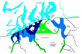
During the Vashon Glaciation a series of lakes formed along the southern margin of the Cordilleran Ice Cap. In the Puget Sound depression, a series of lakes developed, of which Lake Russell was the largest and the longest lasting. Early Lake Russell’s surface was at 160 ft (49 m) above sea level, draining across the divide at Shelton, Washington into early Glacial Lake Russell. When the ice margin receded northward, the lake expanded. When it reached the Clifton channel outlet, the water levels dropped to 120 ft (37 m) above sea level. The new longer and lower level lake is referred to as Lake Hood. The glacier continued to retreat until the northern outlet of the Hood Canal was reached as the water level equalized with Glacial Lake Russell becoming part of that body of water.

During the Vashon Glaciation a series of lakes formed along the southern margin of the Cordilleran Ice Cap. In the Hood Canal depression, two significant lake stages existed, Lake Skokomish and Lake Hood. Early Lake Skokomish’s surface was at 350 ft (110 m) above sea level, draining across the divide at Shelton, Washington into early Glacial Lake Russell. As the glacier receded northward, this freshwater lake grew in size, until the ice was north of the Clifton channel. With the opening of the Clifton channel, the water dropped to 160 m (520 ft) above sea level. This longer and lower level lake is referred to as Lake Hood. The glacier continued to recede northward until it reached the Poulsbo channel. Here, the water level equalized to Glacial Lake Russell nolonger having a separate identify.

Lake Cut Bank was a glacial lake formed during the late Pleistocene along the Missouri and Sun Rivers. After the Laurentide Ice Sheet retreated, water melting off the glacier accumulated between the Rocky Mountinas and the ice sheet. The lake drained along the front of the ice sheet, eastward towards the Judith River and the Missouri River.

