Pierce County is a county in the U.S. state of Washington. As of the 2020 census, the population was 921,130, up from 795,225 in 2010, making it the second-most populous county in Washington, behind King County, and the 59th-most populous in the United States. The county seat and largest city is Tacoma. Formed out of Thurston County on December 22, 1852, by the legislature of Oregon Territory, it was named for U.S. President Franklin Pierce. Pierce County is in the Seattle metropolitan area.
Pickens County is a county located in the northwest part of the U.S. state of South Carolina. As of the 2020 census, its population was 131,404. Its county seat is Pickens. The county was created in 1826. It is part of the Greenville-Anderson-Greer, SC Metropolitan Statistical Area.

Iowa Falls is a city in Hardin County, Iowa, United States. Iowa Falls is the home of Ellsworth Community College. It is also a regional transportation center, located along U.S. Routes 20 and 65 and the Canadian National and Union Pacific Railroads. The population was 5,106 at the time of the 2020 census.

Washington is a city on the south banks of the Missouri River, 50 miles west of St. Louis, Missouri. With an estimated population of 15,075, it is the largest city in Franklin County, Missouri. It is notable for being the "corncob pipe capital of the world," with Missouri Meerschaum located on the city's riverfront.
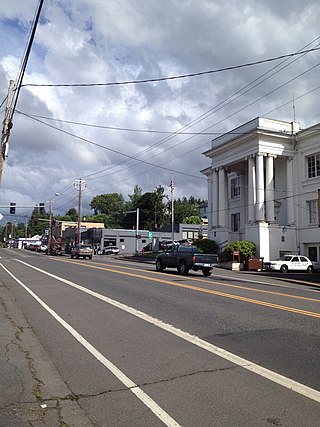
Rainier is a city in Columbia County, Oregon, United States. The city's population was 1,895 at the 2010 census. Rainier is on the south bank of the Columbia River across from Kelso and Longview, Washington.
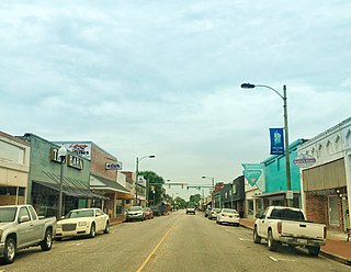
Mullins is a city in Marion County, South Carolina, United States. As of the 2010 census, the city population was 4,663.

Easley is a city in Pickens County in the U.S. state of South Carolina. Most of the city lies in Pickens County, with a small portion of the city in Anderson County.

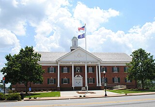
Pickens, formerly called Pickens Courthouse, is a city in and the county seat of Pickens County, South Carolina, United States. The population was 3,126 at the 2010 census. Pickens changed its classification from a town to a city in 1998, but it was not reported to the Census Bureau until 2001. It was named after Andrew Pickens (1739–1817), an American revolutionary soldier and US Congressman for South Carolina.

Buckley is a city in Pierce County, Washington, United States, founded in 1882. The population was 5,114 at the 2020 census. Buckley sits below Mount Rainier and is well known for hosting the annual Log Show.

Carbonado is a town in Pierce County, Washington, United States. It is located near the Carbon River in the north of the county, approximately 50 miles (80 km) southeast of Seattle. Carbonado is the last town before entering Mount Rainier National Park and is also a popular spot for off-roading. The town also served as an important coal mining community in the late nineteenth and early twentieth centuries, when the town operated the largest coal mine in Pierce County. The population was 734 at the 2020 census.

Edgewood is a city in Pierce County, Washington, United States. The population was 12,327 at the 2020 census. Neighboring towns include Fife to the west, Milton to the northwest, Federal Way to the north, Sumner to the east, and Puyallup to the south.

Fife is a city in Pierce County, Washington, United States and a suburb of Tacoma. The population was 10,999 at the 2020 census. Fife is contained within the Puyallup Indian Reservation.

Graham is a census-designated place (CDP) in Pierce County, Washington, United States. It is located 16.2 miles southeast of Tacoma. The population was 23,491 at the 2010 census and grew to 32,658 at the 2020 census.

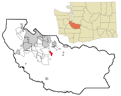
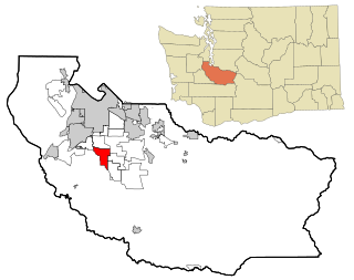
Puyallup is a city in Pierce County, Washington, United States, located about 10 miles (16 km) southeast of Tacoma and 35 miles (56 km) south of Seattle. It had a population of 42,973 at the 2020 census. The city's name comes from the Puyallup Tribe of Native Americans and means "the generous people." Puyallup is home to the Washington State Fair, the state's largest fair. The name of the city is notably used in mailing addresses for adjacent unincorporated areas, such as the larger-populated South Hill.

South Hill is a census-designated place (CDP) in Pierce County, Washington, immediately south of Puyallup. The population was 64,708 at time of the 2020 census, up from 52,431 in 2010. The area primarily consists of suburban housing and shopping with several retail shopping centers, residential neighborhoods, and apartment/condo complexes throughout. Because South Hill is unincorporated, its addresses are part of the Puyallup "postal city" or ZCTA.
Spanaway is a census-designated place (CDP) in Pierce County, Washington, United States. The population was 35,476 at the 2020 census, up from 27,227 in 2010. Spanaway is an unincorporated area near Tacoma, and is often identified together with the more urban, less wealthy Parkland.

Sumner is a city in northern Pierce County, Washington, United States. The population was 10,621 at the 2020 census. Nearby cities include Puyallup to the west, Auburn to the north, and Bonney Lake to the east.

Waller is a rural census-designated place (CDP) in Pierce County, Washington, United States. The population was 8,189 at the 2020 census. The population has seen significant growth in the last decade.

Rainier is a city in Thurston County, Washington, United States. Beginning as a train stop in the 1870s, Rainier was first settled in 1890 and would become known as a logging town. The city was officially incorporated in 1947.
Alderton is a census-designated place (CDP) in Pierce County, Washington, United States. The population was 2,893 at the 2010 census. The community is located in the Puyallup River Valley between the cities of Sumner and Orting.