Fircrest, Washington

Last updated

Fircrest, Washington
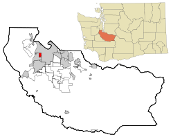
Pierce County Washington Incorporated and Unincorporated areas Fircrest Highlighted.svg
Location of Fircrest, Washington
Coordinates: 47°13′54″N122°30′51″W / 47.23167°N 122.51417°W / 47.23167; -122.51417
CountryUnited States
State Washington
County Pierce
Government
  Type Council–manager
   Mayor Shannon Reynolds
   City manager Dawn Masko
Area
[1]
  Total1.58 sq mi (4.10 km2)
  Land1.58 sq mi (4.10 km2)
  Water0.00 sq mi (0.00 km2)
Elevation
276 ft (84 m)
Population
 (2020) [2]
  Total7,156
  Density4,317.75/sq mi (1,666.63/km2)
Time zone UTC-8 (Pacific (PST))
  Summer (DST) UTC-7 (PDT)
ZIP code
98466
Area code 253
FIPS code 53-23970
GNIS feature ID1512209 [3]
Website cityoffircrest.net

Fircrest is a city in Pierce County, Washington, United States. The population was 7,156 at the 2020 census. [2]

Contents

History

Fircrest was officially incorporated on September 19, 1925. Like its neighbor University Place, it is a middle-class suburb of Tacoma. The community was developed by Edward Bowes, who later gained fame as the host of the Major Bowes Amateur Hour radio talent show. The town attempted to associate itself with academia by naming a number of its streets after universities (e.g. Princeton, Dartmouth, Yale, Vassar, Stanford) and was originally known as Regents Park in a reference to the regents of a university. [4]

Fircrest was the last "dry" municipality in Washington state, prohibiting the sale of alcohol by the glass. Voters chose to allow the sale of alcohol in Fircrest in the November 2015 election. [5]

Geography

Fircrest is located at 47°13′54″N122°30′51″W / 47.23167°N 122.51417°W / 47.23167; -122.51417 (47.231720, -122.514304). [6] The city borders Tacoma to the north and east and University Place to the west and south; the city of Tacoma has an enclave within Fircrest. [7]

According to the United States Census Bureau, the city has a total area of 1.58 square miles (4.09 km2), all of it land. [8]

Government

Since 1990, Fircrest has used a council–manager government, with a city council composed of seven councilmembers. The city mayor is chosen biennially by councilmembers and presides over council meetings. Shannon Reynolds was appointed mayor in 2024. Additionally, the city council appoints a city manager to carry out day-to-day operations of the city and policies of the council. [9] Dawn Masko has been the City Manager of Fircrest since June 2023.

Demographics

Historical population
CensusPop.Note
1930 441
1940 48610.2%
1950 1,459200.2%
1960 3,565144.3%
1970 5,65158.5%
1980 5,477−3.1%
1990 5,258−4.0%
2000 5,86811.6%
2010 6,49710.7%
2020 7,15610.1%
U.S. Decennial Census [10]
2020 Census [2]

2010 census

As of the 2010 census, [11] there were 6,497 people, 2,705 households, and 1,773 families living in the city. The population density was 4,112.0 inhabitants per square mile (1,587.7/km2). There were 2,847 housing units at an average density of 1,801.9 per square mile (695.7/km2). The racial makeup of the city was 78.9% White, 7.0% African American, 0.7% Native American, 5.1% Asian, 0.5% Pacific Islander, 0.8% from other races, and 7.0% from two or more races. Hispanic or Latino of any race were 4.6% of the population.

There were 2,705 households, of which 31.2% had children under the age of 18 living with them, 48.2% were married couples living together, 13.3% had a female householder with no husband present, 4.0% had a male householder with no wife present, and 34.5% were non-families. 28.7% of all households were made up of individuals, and 13.6% had someone living alone who was 65 years of age or older. The average household size was 2.39 and the average family size was 2.93.

The median age in the city was 41.2 years. 23.3% of residents were under the age of 18; 7% were between the ages of 18 and 24; 24.8% were from 25 to 44; 27.5% were from 45 to 64; and 17.3% were 65 years of age or older. The gender makeup of the city was 46.1% male and 53.9% female.

2000 census

As of the 2000 census, there were 5,868 people, 2,505 households, and 1,673 families living in the city. The population density was 3,759.4 people per square mile (1,452.3/km2). There were 2,573 housing units at an average density of 1,648.4 per square mile (636.8/km2). The racial makeup of the city was 87.46% White, 5.20% African American, 0.56% Native American, 2.69% Asian, 0.51% Pacific Islander, 0.46% from other races, and 3.12% from two or more races. Hispanic or Latino of any race were 2.69% of the population.

There were 2,505 households, out of which 28.3% had children under the age of 18 living with them, 53.4% were married couples living together, 10.7% had a female householder with no husband present, and 33.2% were non-families. 28.5% of all households were made up of individuals, and 13.3% had someone living alone who was 65 years of age or older. The average household size was 2.34 and the average family size was 2.85.

In the city, the population was spread out, with 23.1% under the age of 18, 5.5% from 18 to 24, 26.3% from 25 to 44, 24.7% from 45 to 64, and 20.4% who were 65 years of age or older. The median age was 42 years. For every 100 females, there were 88.3 males. For every 100 females age 18 and over, there were 83.8 males.

The median income for a household in the city was $54,912, and the median income for a family was $61,611. Males had a median income of $46,611 versus $32,232 for females. The per capita income for the city was $27,244. 5.9% of the population and 4.6% of families were below the poverty line. Out of the total population, 10.2% of those under the age of 18 and 2.7% of those 65 and older were living below the poverty line.
Education

Most of Fircrest is in the Tacoma Public Schools district, while a part is in the University Place School District. [12]

Related Research Articles

<span class="mw-page-title-main">Tamalpais-Homestead Valley, California</span> Census-designated place in California, United States

Tamalpais-Homestead Valley is a census-designated place (CDP) in Marin County, California, United States. The population was 11,492 at the 2020 census.

<span class="mw-page-title-main">Inkom, Idaho</span> City in Idaho, United States

Inkom is a city in Bannock County, Idaho. It is part of the Pocatello, Idaho Metropolitan Statistical Area. The population was 854 at the time of the 2010 census. It is the home of the smallest airport in the world, Simko Field Airport 1ID9, with a runway length of 122 meters.

<span class="mw-page-title-main">Dubois, Idaho</span> City in Idaho, United States

Dubois is a city in Clark County, Idaho, United States. The population was 511 at the 2020 census. The city is the county seat of Clark County.

<span class="mw-page-title-main">Waucoma, Iowa</span> City in Iowa, United States

Waucoma is a city in Fayette County, Iowa, United States. The population was 229 at the time of the 2020 census.

<span class="mw-page-title-main">Alden, Kansas</span> City in Rice County, Kansas

Alden is a city in Rice County, Kansas, United States. As of the 2020 census, the population of the city was 122.

<span class="mw-page-title-main">Hollandale, Minnesota</span> City in Minnesota, United States

Hollandale is a city on State Highway 251 in Freeborn County, Minnesota, United States. The population was 303 at the 2010 census.

<span class="mw-page-title-main">Lakeland South, Washington</span> Census-designated place in Washington, United States

Lakeland South is a census-designated place (CDP) in King County, Washington, United States. The population was 13,169 at the 2020 census.

<span class="mw-page-title-main">Fife, Washington</span> City in Washington, United States

Fife is a city in Pierce County, Washington, United States and a suburb of Tacoma. The population was 10,999 at the 2020 census. Fife is contained within the Puyallup Indian Reservation.

<span class="mw-page-title-main">Roy, Washington</span> City in Washington, United States

Roy is a city in Pierce County, Washington, United States. The population was 816 at the 2020 census.

<span class="mw-page-title-main">Waller, Washington</span> CDP in Washington, United States

Waller is a census-designated place (CDP) in Pierce County, Washington, United States. The population was 8,189 at the 2020 census. The population has seen significant growth in the last decade.

<span class="mw-page-title-main">Arlington Heights, Washington</span> CDP in Washington, United States

Arlington Heights is a census-designated place (CDP) in Snohomish County, Washington, United States. As of the 2020 census, the population was 2,477, up from 2,284 at the 2010 census.

<span class="mw-page-title-main">North Marysville, Washington</span> CDP in Washington, United States

North Marysville is a census-designated place (CDP) in Snohomish County, Washington, United States. The majority of the community and its 20,000 residents were annexed into the city of Marysville in 2009. The population was 108 at the 2010 census.

<span class="mw-page-title-main">Lake Stickney, Washington</span> CDP in Washington, United States

Lake Stickney is a census-designated place (CDP) in Snohomish County, Washington, United States. The population was 15,413 at the 2020 census. The CDP was known as Paine Field-Lake Stickney prior to 2010. The new Lake Stickney CDP no longer contains the Paine Field airport.

<span class="mw-page-title-main">Chester, West Virginia</span> City in West Virginia, United States

Chester is a city in northern Hancock County, West Virginia, United States, along the Ohio River. The population was 2,214 at the 2020 census. Located immediately south of Ohio and just west of Pennsylvania, Chester is the northernmost city in West Virginia. It is a part of the Weirton–Steubenville metropolitan area, and is home to the World's Largest Teapot.

<span class="mw-page-title-main">Blackwell, Wisconsin</span> Town in Wisconsin, United States

Blackwell is a town in Forest County, Wisconsin. The population was 332 at the time of the 2010 census. The unincorporated community of Blackwell is located in the town. The unincorporated community of Blackwell Junction is also located partially in the town. The town was named for sawmill owner John Blackwell.

<span class="mw-page-title-main">Shelby, Iowa</span> City in Iowa, United States

Shelby is a city in Pottawattamie and Shelby counties in the U.S. state of Iowa. The population was 727 at the time of the 2020 census.

<span class="mw-page-title-main">Pacific, Washington</span> City in Washington, United States

Pacific is a city in King and Pierce counties in the State of Washington. Located primarily in King County, the population was 7,235 at the 2020 census.

<span class="mw-page-title-main">Belle Haven, Accomack County, Virginia</span> Town in Virginia, United States

Belle Haven is a town in Accomack and Northampton counties in the U.S. state of Virginia. The population was 532 at the 2010 census.

<span class="mw-page-title-main">Bridgewater (CDP), Massachusetts</span> Census-designated place in Massachusetts, United States

Bridgewater was a census-designated place (CDP) in the town of Bridgewater in Plymouth County, Massachusetts, United States. The CDP ceased to exist when Bridgewater was given de facto city status in 2010. The population was 7,841 at the 2010 census.

<span class="mw-page-title-main">East Millinocket, Maine</span> Town in the state of Maine, United States

East Millinocket is a town in Penobscot County, Maine, United States. The population was 1,572 at the 2020 census.

References

  1. "2019 U.S. Gazetteer Files". United States Census Bureau. Retrieved August 7, 2020.
  2. 1 2 3 "2020 Census Redistricting Data (Public Law 94-171) Summary File". American FactFinder. United States Census Bureau . Retrieved May 16, 2022.
  3. "US Board on Geographic Names". United States Geological Survey. October 25, 2007. Retrieved January 31, 2008.
  4. "Fircrest, last dry town left in state, is voting on booze". Seattle Times. October 24, 2015. Retrieved October 25, 2015.
  5. "Fircrest voters ending liquor-sale ban". Seattle Times. November 3, 2015. Retrieved December 18, 2015.
  6. "US Gazetteer files: 2010, 2000, and 1990". United States Census Bureau. February 12, 2011. Retrieved April 23, 2011.
  7. WSDOT – City Limits (Map). Washington State Department of Transportation. September 2023. Retrieved February 14, 2024 via Washington Geospatial Open Data Portal.
  8. "US Gazetteer files 2010". United States Census Bureau. Archived from the original on January 25, 2012. Retrieved December 19, 2012.
  9. "City Council - City of Fircrest". City of Fircrest. Retrieved February 4, 2020.
  10. United States Census Bureau. "Census of Population and Housing" . Retrieved July 25, 2013.
  11. "U.S. Census website". United States Census Bureau . Retrieved December 19, 2012.
  12. 2020 Census – School District Reference Map: Pierce County, WA (PDF) (Map). United States Census Bureau. pp. 1-2 (PDF p. 2-3/4). Retrieved July 20, 2022.