
Chicago Heights is a city in Cook County, Illinois, United States. The population was 27,480 at the 2020 census. It is part of the Chicago metropolitan area. Its nicknames include "The Crossroads of the Nation" and "The Heights”.

Washington Heights is a neighborhood in the northern part of the borough of Manhattan in New York City. It is named for Fort Washington, a fortification constructed at the highest natural point on Manhattan by Continental Army troops to defend the area from the British forces during the American Revolutionary War. Washington Heights is bordered by Inwood to the north along Dyckman Street, by Harlem to the south along 155th Street, by the Harlem River and Coogan's Bluff to the east, and by the Hudson River to the west.

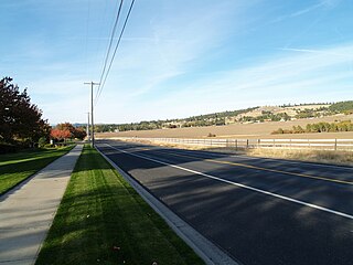
The Palouse is a distinct geographic region of the northwestern United States, encompassing parts of north central Idaho, southeastern Washington, and, by some definitions, parts of northeast Oregon. It is a major agricultural area, primarily producing wheat and legumes. Situated about 160 miles (260 km) north of the Oregon Trail, the region experienced rapid growth in the late 19th century.
La Prairie is a federal electoral district in Quebec, Canada, that was represented in the House of Commons of Canada from 1867 to 1896, 1968 to 1997 and again since 2015.
Winnetka Heights is one of the oldest and largest historical districts in the Oak Cliff section of Dallas, Texas (USA). The district is bounded by Davis Street on the north, 12th Street on the south, Willomet Avenue on the east and Rosemont Avenue on the west. Established in 1910, Winnetka Heights consists of early 20th century wood-frame houses.

The black-tailed prairie dog is a rodent of the family Sciuridae found in the Great Plains of North America from about the United States–Canada border to the United States–Mexico border. Unlike some other prairie dogs, these animals do not truly hibernate. The black-tailed prairie dog can be seen above ground in midwinter. A black-tailed prairie dog town in Texas was reported to cover 25,000 sq mi (64,000 km2) and included 400,000,000 individuals. Prior to habitat destruction, the species may have been the most abundant prairie dog in central North America. It was one of two prairie dogs described by the Lewis and Clark Expedition in the journals and diaries of their expedition.
Sun Prairie East High School (SPEHS) is a public high school in Sun Prairie, Wisconsin, United States. It is one of two high schools in the Sun Prairie Area School District, the other being Sun Prairie West High School. During the 2022-2023 school year, there were 1,365 students at Sun Prairie East High School. SPEHS is a WIAA Division 1 school and is a member of the Big Eight athletic conference in all sports except for football, in which it is a WIAA Division 2 school and a member of the Badger Conference.
The list of neighborhoods of Kansas City, Missouri has nearly 240 neighborhoods. The list includes only Kansas City, Missouri and not the entire Kansas City metropolitan area, such as Kansas City, Kansas.

Crystal Heights was a design by American architect Frank Lloyd Wright for a hotel, apartment, and shopping complex in Washington, D.C. The project would have been built on one of the largest remaining undeveloped tracts in the city, known as the Oak Lawn estate or Temple Heights, on the edge of the Adams Morgan and Dupont Circle neighborhoods. The site was bounded by 19th Street, Columbia Road, Connecticut Avenue, and Florida Avenue, all in the northwest quadrant.
Georgian Heights is a neighborhood in West Columbus, in Columbus, Ohio, United States. It neighbors Holly Hill. The two are bounded together by Sullivant Avenue on the north, Clime Road on the south, Georgesville Road on the west, and Demorest Road on the east. There is a 10.7 acre public park, Georgian Heights Park, in the center of the area. Georgian Heights has a youth travel football team called the Georgian Heights Packers. The neighborhood is generally lower-middle class.

Prairie State College is a public community college in Chicago Heights, Illinois. It is the only college operated by Illinois Community College District 515.

Grand Prairie Township is one of sixteen townships in Jefferson County, Illinois, USA. As of the 2010 census, its population was 909 and it contained 391 housing units.
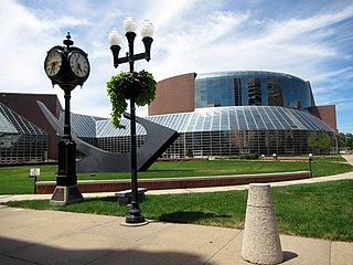
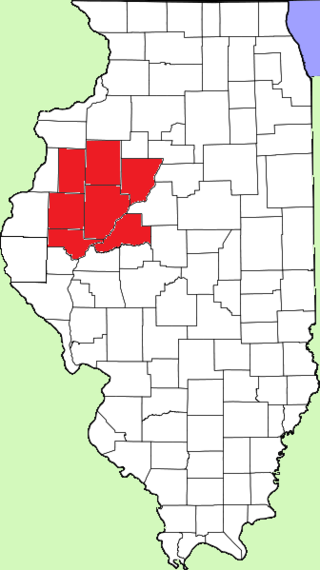
The Peoria Metropolitan Statistical Area, as defined by the United States Census Bureau, is an area consisting of six counties in Central Illinois, anchored by the city of Peoria. As of the 2020 census, the area had a population of 402,391. The City of Peoria, according to the 2020 US Census Bureau, has 113,150 people.
Greeley-Evans Weld County School District 6 is a school district headquartered in Greeley, Colorado, United States. The district serves most of the City of Greeley, the City of Evans, the Town of Garden City, and unincorporated areas in Weld County, including Auburn.
Enid Public Schools is a public school district located in Enid, Oklahoma, USA. The school district had an enrollment of 7,540 students in September 2012.
Landry Heights is a hamlet in northern Alberta, Canada within the Municipal District of Greenview No. 16. It is located approximately 11 kilometres (6.8 mi) west of Highway 40 and 16 kilometres (9.9 mi) southwest of Grande Prairie.
The Prairieland Conference is a high school athletic conference in western central Illinois. The conference participates in athletics and activities in the Illinois High School Association. The conference comprises small public high schools with enrollments between 50 and 400 students in portions of Fulton, Knox, Mason, McDonough, Peoria, Schuyler, and Warren counties.

The Spokane–Spokane Valley Metropolitan Statistical Area, as defined by the United States Census Bureau, is an area consisting of Spokane and Stevens counties in Washington state, anchored by the city of Spokane and its largest suburb, Spokane Valley. As of July 1, 2021, the MSA had an estimated population of 593,466. The Spokane Metropolitan Area and the neighboring Coeur d'Alene metropolitan area, make up the larger Spokane–Coeur d'Alene combined statistical area. The urban areas of the two MSAs largely follow the path of Interstate 90 between Spokane and Coeur d'Alene. In 2010, the Spokane–Spokane Valley MSA had a gross metropolitan product of $20.413 billion.
Glenrose is an unincorporated community in Spokane County, Washington, United States. It is a rural and suburban community split between sections of farmland with many canola fields and new construction of single-family homes. The community is bounded by mountains on two sides and the Spokane urban area on the other two.

