
Washington County is a county in the U.S. state of New York. As of the 2020 census, the population was 61,302. The county seat is Fort Edward. The county was named for U.S. President George Washington. The county is part of the Capital District region of the state.

Pierce County is a county in the U.S. state of Washington. As of the 2020 census, the population was 921,130, up from 795,225 in 2010, making it the second-most populous county in Washington, behind King County, and the 59th-most populous in the United States. The county seat and largest city is Tacoma. Formed out of Thurston County on December 22, 1852, by the legislature of Oregon Territory, it was named for U.S. President Franklin Pierce. Pierce County is in the Seattle metropolitan area.

Washington County is a county in the U.S. state of Nebraska. As of the 2020 United States Census, the population was 20,865. Its county seat is Blair. Washington County is part of the Omaha-Council Bluffs, NE-IA Metropolitan Statistical Area. In the Nebraska license plate system, Washington County is represented by the prefix 29.

Mount Vernon is a census-designated place (CDP) and unincorporated community in Fairfax County, Virginia, United States. The population was 12,914 at the 2020 census. Primarily due to its historical significance and natural recreation and beauty, the Mount Vernon area receives over one million tourists each year.
Fort Lewis is a United States Army base located 9.1 miles (14.6 km) south-southwest of Tacoma, Washington. Fort Lewis was merged with McChord Air Force Base on February 1, 2010, to form Joint Base Lewis–McChord.

McChord Field is a United States Air Force base in the northwest United States, in Pierce County, Washington. South of Tacoma, McChord AFB is the home of the 62nd Airlift Wing, Air Mobility Command, the airbase's primary mission being worldwide strategic airlift.
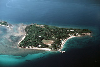
Fort Wint was part of the harbor defenses of Manila and Subic Bays built by the Philippine Department of the United States Army between 1907 and 1920 in response to recommendations of the Taft Board prior to the non-fortification clause of the Washington Naval Treaty. Fort Wint was located on Grande Island at the entrance of Subic Bay, approximately 35 miles (56 km) north of Manila Bay. The fort was named for Brigadier General Theodore J. Wint. As specified in the National Defense Act of 1935, this was one of the locations where coastal artillery training was conducted. A battery of the 60th Coast Artillery (AA) was stationed here.
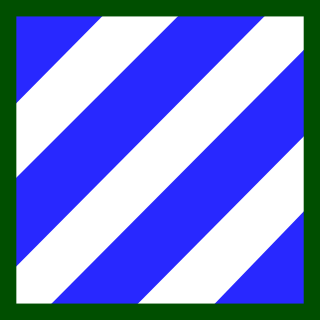
The 3rd Infantry Division (3ID) is a combined arms division of the United States Army based at Fort Stewart, Georgia. It is a subordinate unit of the XVIII Airborne Corps under U.S. Army Forces Command. Its current organization includes a division headquarters and headquarters battalion, two armored brigade combat teams, one aviation brigade, a division artillery, a sustainment brigade and a combat sustainment support battalion along with a maneuver enhancement brigade. The division has a distinguished history, having seen active service in World War I, World War II, the Korean War, and the Global War on Terror. The Medal of Honor has been awarded to 61 members of the 3rd Infantry Division, making the division the most honored in the Army.

Oregon Country was a large region of the Pacific Northwest of North America that was subject to a long dispute between the United Kingdom and the United States in the early 19th century. The area, which had been demarcated by the Treaty of 1818, consisted of the land north of 42° N latitude, south of 54°40′ N latitude, and west of the Rocky Mountains down to the Pacific Ocean and east to the Continental Divide. Article III of the 1818 treaty gave joint control to both nations for ten years, allowed land to be claimed, and guaranteed free navigation to all mercantile trade. However, both countries disputed the terms of the international treaty. Oregon Country was the American name, while the British used Columbia District for the region.

The Treaty of Greenville, also known to Americans as the Treaty with the Wyandots, etc., but formally titled A treaty of peace between the United States of America, and the tribes of Indians called the Wyandots, Delawares, Shawanees, Ottawas, Chippewas, Pattawatimas, Miamis, Eel Rivers, Weas, Kickapoos, Piankeshaws, and Kaskaskias was a 1795 treaty between the United States and indigenous nations of the Northwest Territory, including the Wyandot and Delaware peoples, that redefined the boundary between indigenous peoples' lands and territory for European American community settlement.

Fort Clatsop was the encampment of the Lewis and Clark Expedition in the Oregon Country near the mouth of the Columbia River during the winter of 1805–1806. Located along the Lewis and Clark River at the north end of the Clatsop Plains approximately 5 miles (8.0 km) southwest of Astoria, the fort was the last encampment of the Corps of Discovery, before embarking on their return trip east to St. Louis.
The Lewis and Clark National Historical Park, located in the vicinity of the mouth of the Columbia River, commemorates the Lewis and Clark Expedition. Administration of the park, which includes both federal and state lands, is a cooperative effort of the National Park Service and the states of Oregon and Washington. The National Historical Park was dedicated on November 12, 2004.

The Battle of Fort Duquesne was a British assault on the French-controlled Fort Duquesne that was repulsed with heavy losses on 14 September 1758, during the French and Indian War.

Cape Disappointment State Park is a public recreation area on Cape Disappointment, located southwest of Ilwaco, Washington, on the bottom end of Long Beach Peninsula, the northern headlands where the Columbia River meets the Pacific Ocean. The state park's 2,023 acres (819 ha) encompass a diverse landscape of old-growth forest, freshwater lakes, freshwater and saltwater marshes, and oceanside tidelands. Park sites include Fort Canby, the Lewis and Clark Interpretive Center, North Head Lighthouse, and Cape Disappointment Lighthouse. Cape Disappointment is one of several state parks and sites in Washington and Oregon that are included in Lewis and Clark National Historical Park.
The United States Army Regimental System (USARS) is an organizational and classification system used by the United States Army. It was established in 1981 to replace the Combat Arms Regimental System (CARS) to provide each soldier with continuous identification with a single regiment, and to increase a soldier's probability of serving recurring assignments with their regiment. The USARS was intended to enhance combat effectiveness by providing the opportunity for a regimental affiliation, thus obtaining some of the benefits of the traditional regimental system.

Oregon pioneer history (1806–1890) is the period in the history of Oregon Country and Oregon Territory, in the present day state of Oregon and Northwestern United States.

Sacagawea was a Lemhi Shoshone woman who, in her teens, helped the Lewis and Clark Expedition in achieving their chartered mission objectives by exploring the Louisiana Territory. Sacagawea traveled with the expedition thousands of miles from North Dakota to the Pacific Ocean, helping to establish cultural contacts with Native American people and contributing to the expedition's knowledge of natural history in different regions.
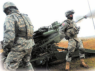
The 9th Field Artillery Regiment is a field artillery regiment of the United States Army first formed in 1916. The regiment served in Hawaii during World War I, 3rd, 4th, 7th, and 9th Divisions between the world wars, and with 3rd Infantry Division during World War II and Korea. Since 1957, the regiment has been a parent regiment under the Combat Arms Regimental System and the U.S. Army Regimental System, with regimental elements serving with the 3rd, 4th, 10th, 25th, 79th, 83rd, and 96th Infantry Divisions and various field artillery brigades and groups. The regiment's single active component, the 1st Battalion, 9th Field Artillery Regiment, is assigned to the 2nd Brigade Combat Team, 3rd Infantry Division and stationed at Fort Stewart, Georgia.

Joint Base Lewis–McChord (JBLM) is a U.S. military installation home to I Corps and 62nd Airlift Wing located 9.1 miles (14.6 km) south-southwest of Tacoma, Washington under the jurisdiction of the United States Army Joint Base Headquarters, Joint Base Lewis–McChord. The facility is an amalgamation of the United States Army's Fort Lewis and the United States Air Force's McChord Air Force Base which merged on 1 February 2010 into a Joint Base as a result of Base Realignment and Closure Commission recommendations of 2005.

Northwest Oregon is a geographic and cultural region of the U.S. state of Oregon, composed of Clatsop, Columbia, and Tillamook counties. The region encompasses the northernmost parts of the state along the lower Columbia River.
