Buckley, Washington

Last updated

Buckley, Washington
Buckley Welcome Sign.jpg
Buckley Welcome Sign
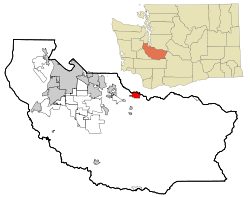
Pierce County Washington Incorporated and Unincorporated areas Buckley Highlighted.svg
Location of Buckley, Washington
Coordinates: 47°09′39″N122°01′00″W / 47.16083°N 122.01667°W / 47.16083; -122.01667
CountryUnited States
State Washington
County Pierce
Incorporated1889
Government
  Type Mayor–council [1]
   Mayor Beau Burkett
Area
[2]
  Total
3.97 sq mi (10.29 km2)
  Land3.86 sq mi (10.00 km2)
  Water0.11 sq mi (0.29 km2)
Elevation
[3]
732 ft (223 m)
Population
 (2020) [4]
  Total
5,114
  Estimate 
(2021) [5]
5,321
  Density1,325/sq mi (511.4/km2)
Time zone UTC-8 (PST)
  Summer (DST) UTC-7 (PDT)
ZIP code
98321
Area code 360
FIPS code 53-08570
GNIS feature ID2409929 [3]
Website cityofbuckley.com

Buckley is a city in Pierce County, Washington, United States, founded in 1882. The population was 5,114 at the 2020 census. [4] Buckley lies on the White River below Mount Rainier and is known for hosting an annual festival named the Log Show.

Contents

History

Buckley High School, about 1912 PostcardBuckleyWABuckleyHighSchool1912.jpg
Buckley High School, about 1912

Geography

Buckley is located on the south side of the White River near the communities of Enumclaw, Bonney Lake, and Wilkeson. The White River forms the border between King and Pierce counties.

According to the United States Census Bureau, the city has a total area of 3.95 square miles (10.23 km2), of which, 3.87 square miles (10.02 km2) is land and 0.08 square miles (0.21 km2) is water. [9]

Climate

According to the Köppen Climate Classification system, Buckley has a warm-summer Mediterranean climate, abbreviated "Csb" on climate maps. [10]

Demographics

Main St. Buckley, WA Main St. Buckley, WA.jpg
Main St. Buckley, WA
Buckley City Hall Buckley City Hall.jpg
Buckley City Hall
Historical population
CensusPop.Note
1890 878
1900 1,01415.5%
1910 1,27225.4%
1920 1,119−12.0%
1930 1,052−6.0%
1940 1,17011.2%
1950 2,705131.2%
1960 3,53830.8%
1970 3,446−2.6%
1980 3,143−8.8%
1990 3,51611.9%
2000 4,14517.9%
2010 4,3545.0%
2020 5,11417.5%
2021 (est.)5,321 [5] 4.0%
U.S. Decennial Census [11]
2020 Census [4]

2010 census

As of the 2010 census, [12] there were 4,354 people, 1,591 households, and 1,049 families residing in the city. The population density was 1,125.1 inhabitants per square mile (434.4/km2). There were 1,669 housing units at an average density of 431.3 per square mile (166.5/km2). The racial makeup of the city was 93.0% White, 0.6% African American, 0.8% Native American, 0.8% Asian, 0.1% Pacific Islander, 1.2% from other races, and 3.4% from two or more races. Hispanic or Latino of any race were 3.1% of the population. By 2014, the city's population remained 93.0% White, and a combined 3.0% Hispanic or Latino.

There were 1,591 households, of which 33.7% had children under the age of 18 living with them, 48.6% were married couples living together, 11.5% had a female householder with no husband present, 5.8% had a male householder with no wife present, and 34.1% were non-families. 26.3% of all households were made up of individuals, and 11.6% had someone living alone who was 65 years of age or older. The average household size was 2.50 and the average family size was 3.00.

The median age in the city was 39.9 years. 22.5% of residents were under the age of 18; 8.9% were between the ages of 18 and 24; 25.4% were from 25 to 44; 30% were from 45 to 64; and 13% were 65 years of age or older. The gender makeup of the city was 50.3% male and 49.7% female. Males remained the dominant gender still in 2014 with a recorded total of 2,191 men and 2,163 women.

2000 census

As of the 2000 census, there were 4,145 people, 1,396 households, and 995 families residing in the city. The population density was 1,072.7 people per square mile (414.6/km2). There were 1,472 housing units at an average density of 380.9 per square mile (147.2/km2). The racial makeup of the city was 93.78% White, 0.63% African American, 1.13% Native American, 0.77% Asian, 0.17% Pacific Islander, 0.55% from other races, and 2.97% from two or more races. Hispanic or Latino of any race were 1.81% of the population.

There were 1,396 households, out of which 38.5% had children under the age of 18 living with them, 54.2% were married couples living together, 12.3% had a female householder with no husband present, and 28.7% were non-families. 22.1% of all households were made up of individuals, and 7.2% had someone living alone who was 65 years of age or older. The average household size was 2.65 and the average family size was 3.12.

In the city, the population was spread out, with 26.4% under the age of 18, 7.4% from 18 to 24, 32.4% from 25 to 44, 24.8% from 45 to 64, and 9.0% who were 65 years of age or older. The median age was 36 years. For every 100 females, there were 102.3 males. For every 100 females age 18 and over, there were 106.9 males.

The median income for a household in the city was $49,453, and the median income for a family was $54,900. Males had a median income of $43,409 versus $29,688 for females. The per capita income for the city was $19,744. About 3.6% of families and 8.3% of the population were below the poverty line, including 6.4% of those under age 18 and 4.9% of those age 65 or over.

Infrastructure

Transportation

Buckley is bisected by State Route 410, a major highway that crosses the Cascades at Chinook Pass and connects the Tacoma area to Yakima. It intersects State Route 165, a highway serving the Carbon River valley, south of town. [13] The Foothills Trail, a non-motorized trail, travels through Buckley and connects the community to Puyallup and Enumclaw. A bridge over the White River for the trail opened in 2024 and became the sole means of access between Buckley and Enumclaw after the bridge carrying State Route 410 was damaged and closed to traffic in August 2025. [14]

Healthcare

The nearest general hospital is St. Elizabeth Hospital in Enumclaw. [14]

Notable people

References

  1. "Government". City of Buckley. Retrieved April 4, 2022.
  2. "2019 U.S. Gazetteer Files". United States Census Bureau. Retrieved August 7, 2020.
  3. 1 2 U.S. Geological Survey Geographic Names Information System: Buckley, Washington
  4. 1 2 3 "Explore Census Data". United States Census Bureau . Retrieved May 16, 2022.
  5. 1 2 "City and Town Population Totals: 2020-2021". United States Census Bureau. June 22, 2022. Retrieved June 22, 2022.
  6. "Nisqually, Klickitat, and Yakama warriors battle U.S. Army soldiers and Territorial Volunteers at Connell".
  7. Stewart, Edgar (1957). Washington: Northwest Frontier. Vol. two. New York: Lewis Historical Publishing Company.
  8. Gatto, J. E. (December 19, 1965). "Mills Built Town of Buckley, First Called Perkins' Prairie". The News Tribune . pp.  8, 17 . Retrieved September 29, 2025 via Newspapers.com.
  9. "US Gazetteer files 2010". United States Census Bureau. Archived from the original on July 2, 2012. Retrieved December 19, 2012.
  10. Climate Summary for Buckley, Washington
  11. "U.S. Decennial Census". Census.gov. Retrieved November 25, 2021.
  12. "U.S. Census website". United States Census Bureau . Retrieved December 19, 2012.
  13. Washington State Department of Transportation (2014). Washington State Highways, 2014–2015 (PDF) (Map). 1:842,000. Olympia: Washington State Department of Transportation. Retrieved September 29, 2025.
  14. 1 2 Deshais, Nicholas (September 17, 2025). "White River Bridge closure: Buckley, Enumclaw go extra mile to connect". The Seattle Times. Retrieved September 29, 2025.